Property Record
4751 Ustick Rd, Nampa, ID 83687
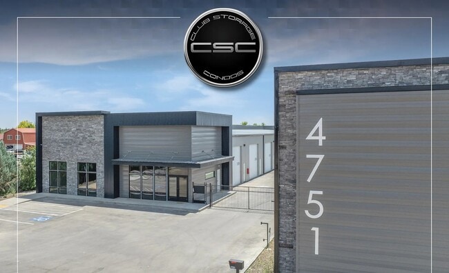
This Property Is For Sale
Current Lease Availabilities
NEARBY LISTINGS FOR SALE OR LEASE
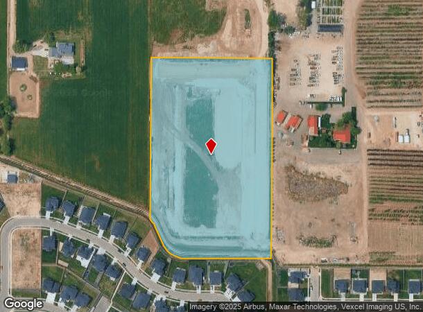
Property Detail
4751 Ustick Rd
Boise City/Nampa
Club Storage Condo
Boise City, ID
Canyon
3036301200
Idaho
Condominium
9.15 AC
X
Nampa
16001C0140J
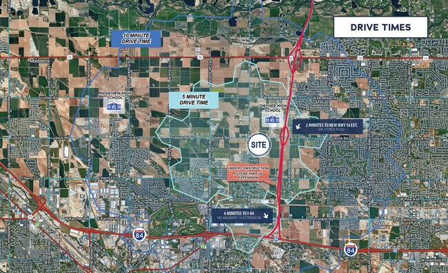
DEMOGRAPHICS near 4751 Ustick Rd
1 Mile
3 Mile
5 Mile
2024 Total Population
810
30,862
125,604
2029 Population
1,110
38,824
155,305
Pop Growth 2024-2029
+ 37.04%
+ 25.80%
+ 23.65%
Average Age
38
38
38
2024 Total Households
275
10,791
43,760
HH Growth 2024-2029
+ 37.82%
+ 26.65%
+ 24.64%
Median Household Inc
$88,888
$88,020
$87,437
Avg Household Size
3.00
2.80
2.80
2024 Avg HH Vehicles
2.00
2.00
2.00
Median Home Value
$441,463
$468,874
$468,022
Median Year Built
2011
2007
2005
Nearby Places
Map Layers
Map Styles
 Street
 Aerial
- Restaurants
- Banks
- Shops
- Fitness
- Groceries
PUBLIC TRANSPORTATION
AIRPORT
Boise Air Trml/Gowen Field
DRIVE
WALK
Distance
Boise Air Trml/Gowen Field
40 min
21.4 mi
Freight Ports
Port of Portland
DRIVE
WALK
Distance
Port of Portland
463 min
418.1 mi
Nearby Properties
Address
Land Use
TOTAL SIZE
Lot Size
Zoning
Address
Land Use
TOTAL SIZE
Lot Size
Zoning
61.03 AC
Address
Land Use
TOTAL SIZE
Lot Size
Zoning
52,235 SF
16.19 AC
Address
Land Use
TOTAL SIZE
Lot Size
Zoning
33.22 AC
M1
Address
Land Use
TOTAL SIZE
Lot Size
Zoning
28.03 AC
M1
Address
Land Use
TOTAL SIZE
Lot Size
Zoning
239,139 SF
38.34 AC
M1
Address
Land Use
TOTAL SIZE
Lot Size
Zoning
27,975 SF
40.88 AC
Address
Land Use
TOTAL SIZE
Lot Size
Zoning
908 SF
48.85 AC
Address
Land Use
TOTAL SIZE
Lot Size
Zoning
17.46 AC
R-15
Address
Land Use
TOTAL SIZE
Lot Size
Zoning
95.54 AC
Address
Land Use
TOTAL SIZE
Lot Size
Zoning
164,916 SF
8.89 AC
R-15
Address
Land Use
TOTAL SIZE
Lot Size
Zoning
262,845 SF
11.97 AC
R-15
Address
Land Use
TOTAL SIZE
Lot Size
Zoning
128,063 SF
10.78 AC
R-15
Address
Land Use
TOTAL SIZE
Lot Size
Zoning
149.04 AC
Address
Land Use
TOTAL SIZE
Lot Size
Zoning
136,249 SF
16.36 AC
Address
Land Use
TOTAL SIZE
Lot Size
Zoning
18.39 AC
Address
Land Use
TOTAL SIZE
Lot Size
Zoning
104,041 SF
4.36 AC
R-15
Address
Land Use
TOTAL SIZE
Lot Size
Zoning
212,196 SF
24.14 AC
Address
Land Use
TOTAL SIZE
Lot Size
Zoning
164,251 SF
21.52 AC
C-G
Address
Land Use
TOTAL SIZE
Lot Size
Zoning
55.24 AC
Address
Land Use
TOTAL SIZE
Lot Size
Zoning
16.19 AC
Address
Land Use
TOTAL SIZE
Lot Size
Zoning
95,785 SF
5.04 AC
Address
Land Use
TOTAL SIZE
Lot Size
Zoning
3.25 AC
R1
Address
Land Use
TOTAL SIZE
Lot Size
Zoning
220,153 SF
11.86 AC
I-L
Address
Land Use
TOTAL SIZE
Lot Size
Zoning
15.56 AC
Address
Land Use
TOTAL SIZE
Lot Size
Zoning
9.64 AC
M1
Address
Land Use
TOTAL SIZE
Lot Size
Zoning
5.90 AC
Address
Land Use
TOTAL SIZE
Lot Size
Zoning
Address
Land Use
TOTAL SIZE
Lot Size
Zoning
64,198 SF
2.74 AC
Address
Land Use
TOTAL SIZE
Lot Size
Zoning
2.21 AC
Address
Land Use
TOTAL SIZE
Lot Size
Zoning
2,412 SF
3.95 AC
RR
The World's #1 Commercial Real Estate Marketplace
Connect with us
© 2026 CoStar Group
The information above has been obtained from sources believed reliable. While we do not doubt its accuracy we have not verified it and make no guarantee, warranty or representation about it. It is your responsibility to independently confirm its accuracy and completeness. Any projections, opinions, assumptions, or estimates used are for example only and do not represent the current or future performance of the property. The value of this transaction to you depends on tax and other factors which should be evaluated by your tax, financial, and legal advisors. You and your advisors should conduct a careful, independent investigation of the property to determine to your satisfaction the suitability of the property for your needs.