Property Record
4755 Liberty Rd S, Salem, OR 97302
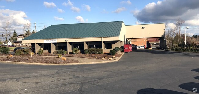


Property Detail
4755 Liberty Rd S
531935
ACRES 1.35
Officebuilding
Marion
CR
Oregon
B and X Area of moderate flood hazard, usually the area between the limits of the 100-year and 500-year floods.
1.35 AC
2024
Marion County
2025
Portland
002202
Salem, OR
5,777 SF
NEARBY LISTINGS FOR SALE OR LEASE
DEMOGRAPHICS near 4755 Liberty Rd S
1 mile
3 mile
5 mile
2024 Total Population
15,750
69,184
136,728
2029 Population
15,838
69,907
138,256
Pop Growth 2024-2029
+ 0.56%
+ 1.05%
+ 1.12%
Average Age
40
41
40
2024 Total Households
6,112
27,425
50,976
HH Growth 2024-2029
+ 0.69%
+ 1.13%
+ 1.17%
Median Household Inc
$86,375
$88,142
$77,788
Avg Household Size
2.50
2.50
2.50
2024 Avg HH Vehicles
2.00
2.00
2.00
Median Home Value
$447,414
$468,047
$454,864
Median Year Built
1977
1981
1978
Nearby Places
Map Layers
Map Styles
 Street
 Aerial
Transit
 Traffic
 Biking
Places
Listings with unknown addresses are not visible on the map
- Restaurants
- Banks
- Shops
- Fitness
- Groceries
PUBLIC TRANSPORTATION
COMMUTER RAIL
Drive
Walk
Distance
8 min
4.2 mi
Nearby Properties
Address
Land Use
TOTAL SIZE
Lot Size
Zoning
Address
Land Use
TOTAL SIZE
Lot Size
Zoning
158,880 SF
8.80 AC
RM2; RM1;
Address
Land Use
TOTAL SIZE
Lot Size
Zoning
62,708 SF
30.21 AC
PH
Address
Land Use
TOTAL SIZE
Lot Size
Zoning
114,647 SF
5.72 AC
RM2; RM1
Address
Land Use
TOTAL SIZE
Lot Size
Zoning
102,124 SF
10.53 AC
CR
Address
Land Use
TOTAL SIZE
Lot Size
Zoning
1,769,016 SF
20.58 AC
CR
Address
Land Use
TOTAL SIZE
Lot Size
Zoning
108,723 SF
7.12 AC
IC
Address
Land Use
TOTAL SIZE
Lot Size
Zoning
204,178 SF
10.43 AC
RM2; PA
Address
Land Use
TOTAL SIZE
Lot Size
Zoning
514,875 SF
28.02 AC
IG
Address
Land Use
TOTAL SIZE
Lot Size
Zoning
140,505 SF
5.84 AC
RM2; RS
Address
Land Use
TOTAL SIZE
Lot Size
Zoning
74,710 SF
9.83 AC
PS
Address
Land Use
TOTAL SIZE
Lot Size
Zoning
72,325 SF
7.79 AC
IBC
Address
Land Use
TOTAL SIZE
Lot Size
Zoning
144,616 SF
7.07 AC
RM2; CO
Address
Land Use
TOTAL SIZE
Lot Size
Zoning
143,684 SF
9.43 AC
CR; RS
Address
Land Use
TOTAL SIZE
Lot Size
Zoning
120,648 SF
16.05 AC
CR
Address
Land Use
TOTAL SIZE
Lot Size
Zoning
Address
Land Use
TOTAL SIZE
Lot Size
Zoning
Address
Land Use
TOTAL SIZE
Lot Size
Zoning
Address
Land Use
TOTAL SIZE
Lot Size
Zoning
124,947 SF
6.27 AC
RM2
Address
Land Use
TOTAL SIZE
Lot Size
Zoning
109,373 SF
4.30 AC
FMU
Address
Land Use
TOTAL SIZE
Lot Size
Zoning
130,360 SF
6.34 AC
RM2
Address
Land Use
TOTAL SIZE
Lot Size
Zoning
115,612 SF
5.87 AC
RM2
Address
Land Use
TOTAL SIZE
Lot Size
Zoning
132,655 SF
6.78 AC
FMU
Address
Land Use
TOTAL SIZE
Lot Size
Zoning
114,559 SF
5.26 AC
RM2
Address
Land Use
TOTAL SIZE
Lot Size
Zoning
54,664 SF
5.81 AC
CO; RM2
Address
Land Use
TOTAL SIZE
Lot Size
Zoning
69,775 SF
5.82 AC
IC
Address
Land Use
TOTAL SIZE
Lot Size
Zoning
80,172 SF
8.56 AC
IBC
Address
Land Use
TOTAL SIZE
Lot Size
Zoning
53,822 SF
3.50 AC
CR
Address
Land Use
TOTAL SIZE
Lot Size
Zoning
62,413 SF
4.91 AC
CR
Address
Land Use
TOTAL SIZE
Lot Size
Zoning
61,013 SF
205.38 AC
P; UT-20
The World's #1 Commercial Real Estate Marketplace
Connect with us
© 2026 CoStar Group
The information above has been obtained from sources believed reliable. While we do not doubt its accuracy we have not verified it and make no guarantee, warranty or representation about it. It is your responsibility to independently confirm its accuracy and completeness. Any projections, opinions, assumptions, or estimates used are for example only and do not represent the current or future performance of the property. The value of this transaction to you depends on tax and other factors which should be evaluated by your tax, financial, and legal advisors. You and your advisors should conduct a careful, independent investigation of the property to determine to your satisfaction the suitability of the property for your needs.