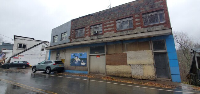
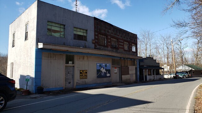
Property Record
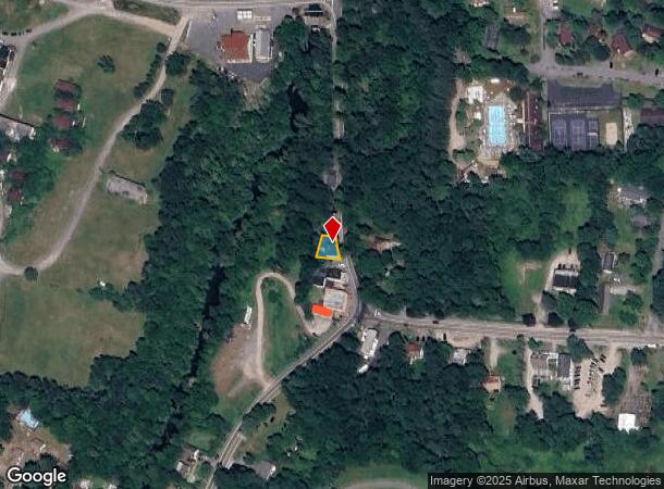
4757 State Route 55, Swan Lake, NY 12783
NEARBY LISTINGS FOR SALE OR LEASE
-
-
View all Swan Lake listings for sale on LoopNet.com
Property Detail
4757 State Route 55
Commercialofficeresidentialmixeduse
Sullivan
X
New York
36105C0293F
51.000
2025
0.10 AC
2024
Hudson Valley Area
951900
Other Market Areas
4,208 SF
3689-044-0-0001-051-000
DEMOGRAPHICS near 4757 State Route 55
1 Mile
3 Mile
5 Mile
2024 Total Population
324
2,151
10,714
2029 Population
340
2,236
11,042
Pop Growth 2024-2029
+ 4.94%
+ 3.95%
+ 3.06%
Average Age
43
42
41
2024 Total Households
127
845
4,129
HH Growth 2024-2029
+ 5.51%
+ 4.26%
+ 3.32%
Median Household Inc
$54,687
$43,916
$45,659
Avg Household Size
2.30
2.40
2.40
2024 Avg HH Vehicles
1.00
2.00
1.00
Median Home Value
$180,644
$183,410
$160,500
Median Year Built
1981
1973
1965
Nearby Places
- Restaurants
- Banks
- Shops
- Fitness
- Groceries
SALE & LEASE HISTORY
LISTING DATE
SALE/LEASE

Nov 10, 2020
For Sale
Nearby Properties
Address
Land Use
TOTAL SIZE
Lot Size
Zoning
Address
Land Use
TOTAL SIZE
Lot Size
Zoning
1,720 SF
173.94 AC
02 - SINGL
Address
Land Use
TOTAL SIZE
Lot Size
Zoning
6,832 SF
31.50 AC
RD
Address
Land Use
TOTAL SIZE
Lot Size
Zoning
21,600 SF
7.10 AC
SC
Address
Land Use
TOTAL SIZE
Lot Size
Zoning
51,700 SF
70.86 AC
CI / RR1
Address
Land Use
TOTAL SIZE
Lot Size
Zoning
1,276 SF
38.26 AC
05 - COMME
Address
Land Use
TOTAL SIZE
Lot Size
Zoning
3,196 SF
80.90 AC
RD2
Address
Land Use
TOTAL SIZE
Lot Size
Zoning
9,548 SF
99.88 AC
02 - SINGL
Address
Land Use
TOTAL SIZE
Lot Size
Zoning
20,925 SF
27 AC
RD
Address
Land Use
TOTAL SIZE
Lot Size
Zoning
2,520 SF
186.74 AC
02 - SINGL
Address
Land Use
TOTAL SIZE
Lot Size
Zoning
6,870 SF
61.41 AC
RS
Address
Land Use
TOTAL SIZE
Lot Size
Zoning
3,945 SF
171.24 AC
02 - SINGL
Address
Land Use
TOTAL SIZE
Lot Size
Zoning
12,360 SF
161.74 AC
RD
Address
Land Use
TOTAL SIZE
Lot Size
Zoning
16,176 SF
20.16 AC
RD
Address
Land Use
TOTAL SIZE
Lot Size
Zoning
6,048 SF
105.58 AC
RD2
Address
Land Use
TOTAL SIZE
Lot Size
Zoning
9,922 SF
62.53 AC
IC
Address
Land Use
TOTAL SIZE
Lot Size
Zoning
5,460 SF
65 AC
RD
Address
Land Use
TOTAL SIZE
Lot Size
Zoning
9,543 SF
67.02 AC
IC
Address
Land Use
TOTAL SIZE
Lot Size
Zoning
3,808 SF
65.70 AC
RD
Address
Land Use
TOTAL SIZE
Lot Size
Zoning
165,344 SF
34.23 AC
RH
Address
Land Use
TOTAL SIZE
Lot Size
Zoning
18.96 AC
RD
Address
Land Use
TOTAL SIZE
Lot Size
Zoning
1,344 SF
116.70 AC
RD
Address
Land Use
TOTAL SIZE
Lot Size
Zoning
12,799 SF
28.20 AC
02 - SINGL
Address
Land Use
TOTAL SIZE
Lot Size
Zoning
10,320 SF
27.50 AC
RD2
Address
Land Use
TOTAL SIZE
Lot Size
Zoning
1,000 SF
3.52 AC
R1
Address
Land Use
TOTAL SIZE
Lot Size
Zoning
5,249 SF
62.53 AC
IC
Address
Land Use
TOTAL SIZE
Lot Size
Zoning
1,716 SF
6.93 AC
02 - SINGL
Address
Land Use
TOTAL SIZE
Lot Size
Zoning
15,110 SF
62.53 AC
IC
Address
Land Use
TOTAL SIZE
Lot Size
Zoning
4,728 SF
17.34 AC
SC
Address
Land Use
TOTAL SIZE
Lot Size
Zoning
12,670 SF
4.63 AC
IC
Address
Land Use
TOTAL SIZE
Lot Size
Zoning
516 SF
21.90 AC
02 - SINGL
The World's #1 Commercial Real Estate Marketplace
Connect with us
© 2025 CoStar Group
The information above has been obtained from sources believed reliable. While we do not doubt its accuracy we have not verified it and make no guarantee, warranty or representation about it. It is your responsibility to independently confirm its accuracy and completeness. Any projections, opinions, assumptions, or estimates used are for example only and do not represent the current or future performance of the property. The value of this transaction to you depends on tax and other factors which should be evaluated by your tax, financial, and legal advisors. You and your advisors should conduct a careful, independent investigation of the property to determine to your satisfaction the suitability of the property for your needs.