Property Record
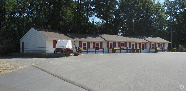
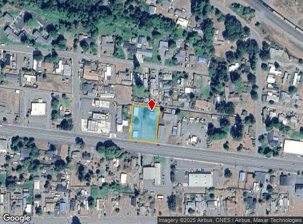
47585 Highway 58, Oakridge, OR 97463
NEARBY LISTINGS FOR SALE OR LEASE
-
-
View all Oakridge listings for sale on LoopNet.com
Property Detail
47585 Highway 58
Eugene, OR
Middle Fork
0961167
TL 06300
Commercialbuilding
Lane
X
Oregon
41039C2476F
6300
2025
0.46 AC
2025
Lane County
0015003022
Portland
1,912 SF
DEMOGRAPHICS near 47585 Highway 58
1 Mile
3 Mile
5 Mile
2024 Total Population
3,001
4,730
5,058
2029 Population
3,066
4,833
5,170
Pop Growth 2024-2029
+ 2.17%
+ 2.18%
+ 2.21%
Average Age
46
46
46
2024 Total Households
1,398
2,121
2,254
HH Growth 2024-2029
+ 2.07%
+ 2.17%
+ 2.17%
Median Household Inc
$33,807
$35,024
$35,161
Avg Household Size
2.10
2.20
2.20
2024 Avg HH Vehicles
2.00
2.00
2.00
Median Home Value
$142,452
$172,045
$181,126
Median Year Built
1970
1966
1966
Nearby Places
Map Layers
Map Styles
 Street
 Aerial
- Restaurants
- Banks
- Shops
- Fitness
- Groceries
SALE & LEASE HISTORY
LISTING DATE
SALE/LEASE

Jul 03, 2021
For Sale
Nearby Properties
Address
Land Use
TOTAL SIZE
Lot Size
Zoning
Address
Land Use
TOTAL SIZE
Lot Size
Zoning
5.58 AC
R1
Address
Land Use
TOTAL SIZE
Lot Size
Zoning
5,615.58 AC
F1
Address
Land Use
TOTAL SIZE
Lot Size
Zoning
1,024 SF
395.48 AC
F1
Address
Land Use
TOTAL SIZE
Lot Size
Zoning
248.60 AC
C3
Address
Land Use
TOTAL SIZE
Lot Size
Zoning
2.85 AC
F2
Address
Land Use
TOTAL SIZE
Lot Size
Zoning
16.05 AC
RPF
Address
Land Use
TOTAL SIZE
Lot Size
Zoning
1.24 AC
C3
Address
Land Use
TOTAL SIZE
Lot Size
Zoning
2.09 AC
C3
Address
Land Use
TOTAL SIZE
Lot Size
Zoning
0.95 AC
C3
Address
Land Use
TOTAL SIZE
Lot Size
Zoning
0.61 AC
C3
Address
Land Use
TOTAL SIZE
Lot Size
Zoning
0.80 AC
C3
Address
Land Use
TOTAL SIZE
Lot Size
Zoning
2.12 AC
PRO-S
Address
Land Use
TOTAL SIZE
Lot Size
Zoning
0.95 AC
C3
Address
Land Use
TOTAL SIZE
Lot Size
Zoning
5.11 AC
R1
Address
Land Use
TOTAL SIZE
Lot Size
Zoning
39.24 AC
F2
Address
Land Use
TOTAL SIZE
Lot Size
Zoning
0.73 AC
R1
Address
Land Use
TOTAL SIZE
Lot Size
Zoning
4.89 AC
R1
Address
Land Use
TOTAL SIZE
Lot Size
Zoning
0.73 AC
C3
Address
Land Use
TOTAL SIZE
Lot Size
Zoning
0.64 AC
C2
Address
Land Use
TOTAL SIZE
Lot Size
Zoning
1.19 AC
C3
Address
Land Use
TOTAL SIZE
Lot Size
Zoning
91.20 AC
PR
Address
Land Use
TOTAL SIZE
Lot Size
Zoning
0.54 AC
C3
Address
Land Use
TOTAL SIZE
Lot Size
Zoning
6.12 AC
I2
Address
Land Use
TOTAL SIZE
Lot Size
Zoning
956.81 AC
F1
Address
Land Use
TOTAL SIZE
Lot Size
Zoning
4.48 AC
I1
Address
Land Use
TOTAL SIZE
Lot Size
Zoning
1.27 AC
R1
Address
Land Use
TOTAL SIZE
Lot Size
Zoning
3.07 AC
C3
Address
Land Use
TOTAL SIZE
Lot Size
Zoning
0.36 AC
F2
Address
Land Use
TOTAL SIZE
Lot Size
Zoning
0.79 AC
C3
Address
Land Use
TOTAL SIZE
Lot Size
Zoning
810 SF
1 AC
C3
The World's #1 Commercial Real Estate Marketplace
Connect with us
© 2025 CoStar Group
The information above has been obtained from sources believed reliable. While we do not doubt its accuracy we have not verified it and make no guarantee, warranty or representation about it. It is your responsibility to independently confirm its accuracy and completeness. Any projections, opinions, assumptions, or estimates used are for example only and do not represent the current or future performance of the property. The value of this transaction to you depends on tax and other factors which should be evaluated by your tax, financial, and legal advisors. You and your advisors should conduct a careful, independent investigation of the property to determine to your satisfaction the suitability of the property for your needs.