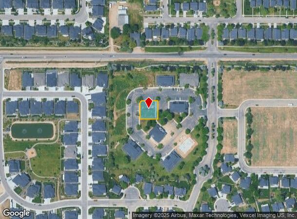
Property Record
4759 N Summit Way, Meridian, ID 83646
NEARBY LISTINGS FOR SALE OR LEASE
Property Detail
4759 N Summit Way
Boise City, ID
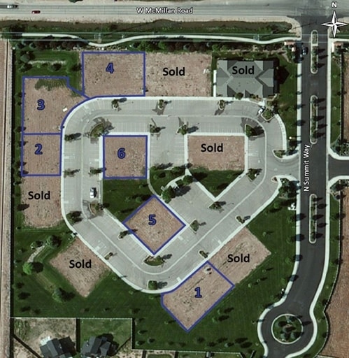
Cedar Springs Sub No 05
R1333210170
LOT 18 BLK 37 CEDAR SPRINGS SUB NO 05
Commercialacreage
Ada
X
Idaho
16027C0300F
18
2024
0.25 AC
2025
Meridian
010363
Boise City/Nampa
DEMOGRAPHICS near 4759 N Summit Way
1 Mile
3 Mile
5 Mile
2024 Total Population
17,667
96,442
184,820
2029 Population
19,886
109,268
210,410
Pop Growth 2024-2029
+ 12.56%
+ 13.30%
+ 13.85%
Average Age
36
39
40
2024 Total Households
5,524
33,796
66,695
HH Growth 2024-2029
+ 12.76%
+ 13.59%
+ 14.17%
Median Household Inc
$117,587
$90,849
$86,682
Avg Household Size
3.10
2.80
2.70
2024 Avg HH Vehicles
2.00
2.00
2.00
Median Home Value
$454,403
$446,836
$466,325
Median Year Built
2009
2003
2002
Nearby Places
Map Layers
Map Styles
 Street
 Aerial
- Restaurants
- Banks
- Shops
- Fitness
- Groceries
PUBLIC TRANSPORTATION
AIRPORT
Boise Air Trml/Gowen Field
DRIVE
WALK
Distance
Boise Air Trml/Gowen Field
26 min
15.6 mi
Nearby Properties
Address
Land Use
TOTAL SIZE
Lot Size
Zoning
Address
Land Use
TOTAL SIZE
Lot Size
Zoning
789,114 SF
11.38 AC
C-G
Address
Land Use
TOTAL SIZE
Lot Size
Zoning
415,710 SF
14.78 AC
R-40
Address
Land Use
TOTAL SIZE
Lot Size
Zoning
17.46 AC
R-15
Address
Land Use
TOTAL SIZE
Lot Size
Zoning
335,459 SF
11.23 AC
R-40
Address
Land Use
TOTAL SIZE
Lot Size
Zoning
243,949 SF
13.81 AC
R-40
Address
Land Use
TOTAL SIZE
Lot Size
Zoning
305,889 SF
9.91 AC
R-40
Address
Land Use
TOTAL SIZE
Lot Size
Zoning
203,377 SF
21.13 AC
C-G
Address
Land Use
TOTAL SIZE
Lot Size
Zoning
10.44 AC
R-15
Address
Land Use
TOTAL SIZE
Lot Size
Zoning
190,106 SF
10.10 AC
R-4
Address
Land Use
TOTAL SIZE
Lot Size
Zoning
262,845 SF
11.97 AC
R-15
Address
Land Use
TOTAL SIZE
Lot Size
Zoning
138,828 SF
4.22 AC
ZC-245
Address
Land Use
TOTAL SIZE
Lot Size
Zoning
126,466 SF
5.29 AC
R-40
Address
Land Use
TOTAL SIZE
Lot Size
Zoning
130,060 SF
3.42 AC
C-G
Address
Land Use
TOTAL SIZE
Lot Size
Zoning
98,555 SF
7.65 AC
R-40
Address
Land Use
TOTAL SIZE
Lot Size
Zoning
108,505 SF
6.84 AC
C-G
Address
Land Use
TOTAL SIZE
Lot Size
Zoning
130,827 SF
15.16 AC
I-L
Address
Land Use
TOTAL SIZE
Lot Size
Zoning
170,333 SF
14.65 AC
C-3-DA
Address
Land Use
TOTAL SIZE
Lot Size
Zoning
69,546 SF
4.26 AC
MU-DA
Address
Land Use
TOTAL SIZE
Lot Size
Zoning
65,034 SF
4.44 AC
MU-DA
Address
Land Use
TOTAL SIZE
Lot Size
Zoning
187,091 SF
15.46 AC
C-G
Address
Land Use
TOTAL SIZE
Lot Size
Zoning
89,693 SF
2.43 AC
R-3
Address
Land Use
TOTAL SIZE
Lot Size
Zoning
152,895 SF
14.29 AC
C-G
Address
Land Use
TOTAL SIZE
Lot Size
Zoning
90,035 SF
0.91 AC
O-T
Address
Land Use
TOTAL SIZE
Lot Size
Zoning
164,251 SF
21.52 AC
C-G
Address
Land Use
TOTAL SIZE
Lot Size
Zoning
110,152 SF
6.02 AC
R-40
Address
Land Use
TOTAL SIZE
Lot Size
Zoning
126,128 SF
4.04 AC
I-L
Address
Land Use
TOTAL SIZE
Lot Size
Zoning
28.08 AC
R-8
Address
Land Use
TOTAL SIZE
Lot Size
Zoning
125,400 SF
12.68 AC
ZC-243
Address
Land Use
TOTAL SIZE
Lot Size
Zoning
220,153 SF
11.86 AC
I-L
Address
Land Use
TOTAL SIZE
Lot Size
Zoning
228,384 SF
14.22 AC
C-G
The World's #1 Commercial Real Estate Marketplace
Connect with us
© 2026 CoStar Group
The information above has been obtained from sources believed reliable. While we do not doubt its accuracy we have not verified it and make no guarantee, warranty or representation about it. It is your responsibility to independently confirm its accuracy and completeness. Any projections, opinions, assumptions, or estimates used are for example only and do not represent the current or future performance of the property. The value of this transaction to you depends on tax and other factors which should be evaluated by your tax, financial, and legal advisors. You and your advisors should conduct a careful, independent investigation of the property to determine to your satisfaction the suitability of the property for your needs.