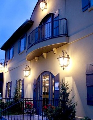
Property Record
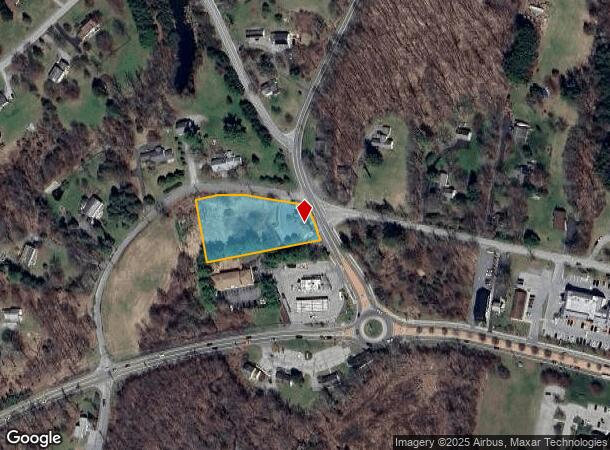
476 Lauer Rd, Poughkeepsie, NY 12603

NEARBY LISTINGS FOR SALE OR LEASE
Property Detail
476 Lauer Rd
133400-6460-01-386999-0000
1.22 AC 1621 0839 1378 0885
Officebuilding
Dutchess
A
New York
36027C0391E
386
2025
1.22 AC
2024
Fishkill
080103
Westchester/So Connecticut
3,504 SF
Dutchess County-Putnam County, NY
DEMOGRAPHICS near 476 Lauer Rd
1 Mile
3 Mile
5 Mile
2024 Total Population
1,543
11,491
46,302
2029 Population
1,580
11,557
46,432
Pop Growth 2024-2029
+ 2.40%
+ 0.57%
+ 0.28%
Average Age
41
42
41
2024 Total Households
567
3,983
15,999
HH Growth 2024-2029
+ 2.47%
+ 0.58%
+ 0.30%
Median Household Inc
$110,035
$125,054
$109,976
Avg Household Size
2.70
2.80
2.70
2024 Avg HH Vehicles
2.00
2.00
2.00
Median Home Value
$403,801
$404,743
$369,658
Median Year Built
1985
1976
1972
Nearby Places
- Restaurants
- Banks
- Shops
- Fitness
- Groceries
PUBLIC TRANSPORTATION
COMMUTER RAIL
Poughkeepsie Station (Hudson Line - Metro-North Commuter Railroad Company (Metro-North))
DRIVE
WALK
Distance
Poughkeepsie Station (Hudson Line - Metro-North Commuter Railroad Company (Metro-North))
13 min
7.9 mi
AIRPORT
New York Stewart International
DRIVE
WALK
Distance
New York Stewart International
46 min
31.7 mi
Freight Ports
Port of New Haven
DRIVE
WALK
Distance
Port of New Haven
100 min
71.9 mi
Nearby Properties
Address
Land Use
TOTAL SIZE
Lot Size
Zoning
Address
Land Use
TOTAL SIZE
Lot Size
Zoning
247,216 SF
65.67 AC
RFD
Address
Land Use
TOTAL SIZE
Lot Size
Zoning
122,319 SF
23.12 AC
TCR
Address
Land Use
TOTAL SIZE
Lot Size
Zoning
6.24 AC
I
Address
Land Use
TOTAL SIZE
Lot Size
Zoning
55,520 SF
26.30 AC
RLD
Address
Land Use
TOTAL SIZE
Lot Size
Zoning
200 SF
486.87 AC
SPR
Address
Land Use
TOTAL SIZE
Lot Size
Zoning
34,805 SF
560.32 AC
SPR
Address
Land Use
TOTAL SIZE
Lot Size
Zoning
48,720 SF
12 AC
RMD
Address
Land Use
TOTAL SIZE
Lot Size
Zoning
3.65 AC
RFD
Address
Land Use
TOTAL SIZE
Lot Size
Zoning
171,944 SF
10.49 AC
GB
Address
Land Use
TOTAL SIZE
Lot Size
Zoning
205,300 SF
18.17 AC
GB
Address
Land Use
TOTAL SIZE
Lot Size
Zoning
48,600 SF
3.88 AC
TCB
Address
Land Use
TOTAL SIZE
Lot Size
Zoning
54,263 SF
8.51 AC
C
Address
Land Use
TOTAL SIZE
Lot Size
Zoning
200,000 SF
14.32 AC
C
Address
Land Use
TOTAL SIZE
Lot Size
Zoning
38,610 SF
14.52 AC
TCB
Address
Land Use
TOTAL SIZE
Lot Size
Zoning
69,448 SF
3.50 AC
I
Address
Land Use
TOTAL SIZE
Lot Size
Zoning
75,183 SF
10.80 AC
C
Address
Land Use
TOTAL SIZE
Lot Size
Zoning
71,124 SF
5.05 AC
TCB
Address
Land Use
TOTAL SIZE
Lot Size
Zoning
21,925 SF
4.20 AC
GB
Address
Land Use
TOTAL SIZE
Lot Size
Zoning
83,570 SF
21 AC
C
Address
Land Use
TOTAL SIZE
Lot Size
Zoning
22,912 SF
14.47 AC
C
Address
Land Use
TOTAL SIZE
Lot Size
Zoning
93,874 SF
4.37 AC
C
Address
Land Use
TOTAL SIZE
Lot Size
Zoning
14,194 SF
1.30 AC
C
Address
Land Use
TOTAL SIZE
Lot Size
Zoning
38,400 SF
2.59 AC
C
Address
Land Use
TOTAL SIZE
Lot Size
Zoning
11,472 SF
28.56 AC
TCR
Address
Land Use
TOTAL SIZE
Lot Size
Zoning
7,458 SF
246.70 AC
RLD
Address
Land Use
TOTAL SIZE
Lot Size
Zoning
32,484 SF
13.49 AC
TCB
Address
Land Use
TOTAL SIZE
Lot Size
Zoning
68,868 SF
7.49 AC
C
Address
Land Use
TOTAL SIZE
Lot Size
Zoning
135.10 AC
RLD
Address
Land Use
TOTAL SIZE
Lot Size
Zoning
21,540 SF
9.80 AC
TCB
Address
Land Use
TOTAL SIZE
Lot Size
Zoning
27,942 SF
2.25 AC
TCB
The World's #1 Commercial Real Estate Marketplace
Connect with us
© 2025 CoStar Group
The information above has been obtained from sources believed reliable. While we do not doubt its accuracy we have not verified it and make no guarantee, warranty or representation about it. It is your responsibility to independently confirm its accuracy and completeness. Any projections, opinions, assumptions, or estimates used are for example only and do not represent the current or future performance of the property. The value of this transaction to you depends on tax and other factors which should be evaluated by your tax, financial, and legal advisors. You and your advisors should conduct a careful, independent investigation of the property to determine to your satisfaction the suitability of the property for your needs.