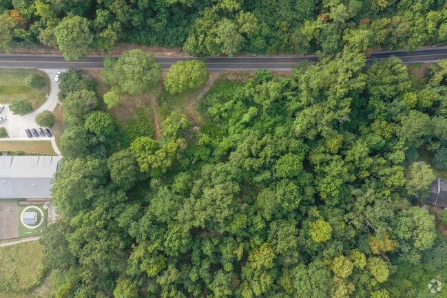
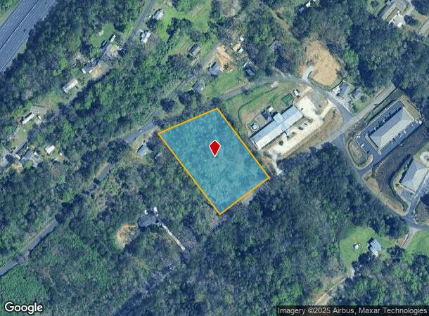
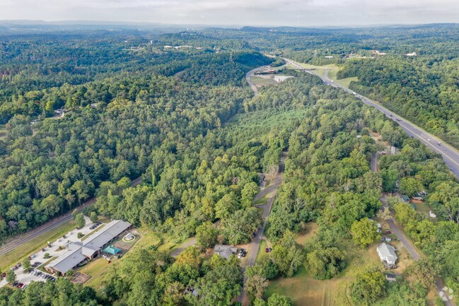
Property Record
4762 Overton Rd, Birmingham, AL 35210

NEARBY LISTINGS FOR SALE OR LEASE
Property Detail
4762 Overton Rd
Birmingham-Hoover, AL
Overton #1 Subdiv
28-00-01-1-007-002.000
LOT 203 OVERTON LAND COS OVERTON NO 1 SUBDIVISION
Vacantlandnec
Jefferson
X
Alabama
01073C0414H
203
2023
2.96 AC
2024
Hwy 280/Jefferson County
010807
Birmingham
DEMOGRAPHICS near 4762 Overton Rd
1 Mile
3 Mile
5 Mile
2024 Total Population
2,179
30,767
92,300
2029 Population
2,089
29,758
91,022
Pop Growth 2024-2029
(4.13%)
(3.28%)
(1.38%)
Average Age
42
40
40
2024 Total Households
781
12,203
39,689
HH Growth 2024-2029
(4.23%)
(3.42%)
(1.47%)
Median Household Inc
$143,382
$103,543
$73,238
Avg Household Size
2.70
2.40
2.20
2024 Avg HH Vehicles
2.00
2.00
2.00
Median Home Value
$447,297
$394,789
$368,492
Median Year Built
1976
1975
1972
Nearby Places
Map Layers
Map Styles
 Street
 Aerial
- Restaurants
- Banks
- Shops
- Fitness
- Groceries
PUBLIC TRANSPORTATION
AIRPORT
Birmingham-Shuttlesworth International
DRIVE
WALK
Distance
Birmingham-Shuttlesworth International
19 min
14.7 mi
Freight Ports
Port of Mobile
DRIVE
WALK
Distance
Port of Mobile
1 min
209.1 mi
SALE & LEASE HISTORY
LISTING DATE
SALE/LEASE

Sep 24, 2016
For Sale
May 03, 2017
For Sale
Jun 20, 2022
For Sale
Aug 27, 2019
For Sale
Nearby Properties
Address
Land Use
TOTAL SIZE
Lot Size
Zoning
Address
Land Use
TOTAL SIZE
Lot Size
Zoning
45,868 SF
6.80 AC
CP Y
Address
Land Use
TOTAL SIZE
Lot Size
Zoning
259,316 SF
30 AC
PUD
Address
Land Use
TOTAL SIZE
Lot Size
Zoning
166,863 SF
21 AC
CB2
Address
Land Use
TOTAL SIZE
Lot Size
Zoning
80,288 SF
2.91 AC
CB2
Address
Land Use
TOTAL SIZE
Lot Size
Zoning
423,995 SF
25 AC
R3
Address
Land Use
TOTAL SIZE
Lot Size
Zoning
144,135 SF
31.95 AC
CR5
Address
Land Use
TOTAL SIZE
Lot Size
Zoning
92,913 SF
15 AC
I3
Address
Land Use
TOTAL SIZE
Lot Size
Zoning
158,161 SF
15.48 AC
C1
Address
Land Use
TOTAL SIZE
Lot Size
Zoning
68,778 SF
3.40 AC
CP
Address
Land Use
TOTAL SIZE
Lot Size
Zoning
125,324 SF
53 AC
INST
Address
Land Use
TOTAL SIZE
Lot Size
Zoning
68,803 SF
3.93 AC
CP
Address
Land Use
TOTAL SIZE
Lot Size
Zoning
198,270 SF
11.21 AC
CP
Address
Land Use
TOTAL SIZE
Lot Size
Zoning
129,702 SF
8.20 AC
C-1
Address
Land Use
TOTAL SIZE
Lot Size
Zoning
131,319 SF
13.28 AC
CB2
Address
Land Use
TOTAL SIZE
Lot Size
Zoning
235,552 SF
10.13 AC
R3
Address
Land Use
TOTAL SIZE
Lot Size
Zoning
57,938 SF
6.85 AC
CP
Address
Land Use
TOTAL SIZE
Lot Size
Zoning
74,154 SF
4.20 AC
R-A
Address
Land Use
TOTAL SIZE
Lot Size
Zoning
83,776 SF
3.79 AC
B6
Address
Land Use
TOTAL SIZE
Lot Size
Zoning
22 AC
CB2
Address
Land Use
TOTAL SIZE
Lot Size
Zoning
210,920 SF
22.41 AC
CB2
Address
Land Use
TOTAL SIZE
Lot Size
Zoning
145,949 SF
10.01 AC
QR6
Address
Land Use
TOTAL SIZE
Lot Size
Zoning
59,108 SF
1.72 AC
CP&C
Address
Land Use
TOTAL SIZE
Lot Size
Zoning
102,748 SF
8.50 AC
CB2
Address
Land Use
TOTAL SIZE
Lot Size
Zoning
8.10 AC
QR6
Address
Land Use
TOTAL SIZE
Lot Size
Zoning
223,365 SF
15 AC
I1
Address
Land Use
TOTAL SIZE
Lot Size
Zoning
64,390 SF
7.10 AC
Address
Land Use
TOTAL SIZE
Lot Size
Zoning
43,566 SF
18.99 AC
C1
Address
Land Use
TOTAL SIZE
Lot Size
Zoning
47,099 SF
2.03 AC
CP
Address
Land Use
TOTAL SIZE
Lot Size
Zoning
52,416 SF
7 AC
A1
Address
Land Use
TOTAL SIZE
Lot Size
Zoning
301,531 SF
41 AC
B5
The World's #1 Commercial Real Estate Marketplace
Connect with us
© 2025 CoStar Group
The information above has been obtained from sources believed reliable. While we do not doubt its accuracy we have not verified it and make no guarantee, warranty or representation about it. It is your responsibility to independently confirm its accuracy and completeness. Any projections, opinions, assumptions, or estimates used are for example only and do not represent the current or future performance of the property. The value of this transaction to you depends on tax and other factors which should be evaluated by your tax, financial, and legal advisors. You and your advisors should conduct a careful, independent investigation of the property to determine to your satisfaction the suitability of the property for your needs.