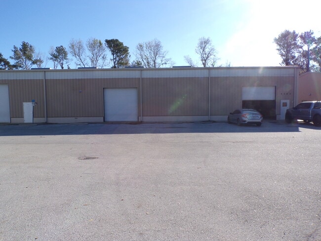
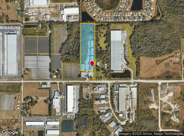
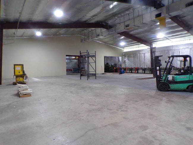
Property Record
4759 Drane Field Rd, Lakeland, FL 33811
Current Lease Availabilities
NEARBY LISTINGS FOR SALE OR LEASE
Property Detail
4759 Drane Field Rd
23-28-31-000000-022070
Alameda Heights
Lightindustrial
W1/4 OF SE1/4 OF SE1/4 LESS S 245 FT LESS E 50 FT THEREOF & LESS S 60 FT FOR DRANEFIELD RD R/W
A
Polk
12105C0460G
Florida
2024
8.45 AC
2025
Polk County
012004
Tampa/St Petersburg
57,000 SF
Lakeland-Winter Haven, FL
DEMOGRAPHICS near 4759 Drane Field Rd
1 Mile
3 Mile
5 Mile
2024 Total Population
1,270
12,872
82,395
2029 Population
1,456
14,706
94,592
Pop Growth 2024-2029
+ 14.65%
+ 14.25%
+ 14.80%
Average Age
48
39
40
2024 Total Households
555
4,472
31,628
HH Growth 2024-2029
+ 14.59%
+ 14.47%
+ 15.26%
Median Household Inc
$98,062
$72,612
$59,392
Avg Household Size
2.30
2.80
2.50
2024 Avg HH Vehicles
2.00
2.00
2.00
Median Home Value
$253,264
$265,238
$208,941
Median Year Built
2004
1997
1986
Nearby Places
- Restaurants
- Banks
- Shops
- Fitness
- Groceries
PUBLIC TRANSPORTATION
COMMUTER RAIL
DRIVE
WALK
Distance
16 min
8.5 mi
AIRPORT
Tampa International
DRIVE
WALK
Distance
Tampa International
49 min
37.8 mi
Freight Ports
Port of Tampa Bay
DRIVE
WALK
Distance
Port of Tampa Bay
42 min
31.2 mi
Nearby Properties
Address
Land Use
TOTAL SIZE
Lot Size
Zoning
Address
Land Use
TOTAL SIZE
Lot Size
Zoning
2,095,234 SF
102.45 AC
PUD
Address
Land Use
TOTAL SIZE
Lot Size
Zoning
1,210,880 SF
405.82 AC
PUD
Address
Land Use
TOTAL SIZE
Lot Size
Zoning
1,494,080 SF
116.77 AC
Address
Land Use
TOTAL SIZE
Lot Size
Zoning
518,028 SF
195.69 AC
Address
Land Use
TOTAL SIZE
Lot Size
Zoning
705,615 SF
33.05 AC
Address
Land Use
TOTAL SIZE
Lot Size
Zoning
711,568 SF
42.87 AC
PD
Address
Land Use
TOTAL SIZE
Lot Size
Zoning
805,336 SF
52.50 AC
I
Address
Land Use
TOTAL SIZE
Lot Size
Zoning
779,760 SF
67.03 AC
I
Address
Land Use
TOTAL SIZE
Lot Size
Zoning
595,473 SF
47.29 AC
Address
Land Use
TOTAL SIZE
Lot Size
Zoning
711,568 SF
43.33 AC
PD
Address
Land Use
TOTAL SIZE
Lot Size
Zoning
655,123 SF
45.28 AC
Address
Land Use
TOTAL SIZE
Lot Size
Zoning
508,310 SF
37.85 AC
M-1A
Address
Land Use
TOTAL SIZE
Lot Size
Zoning
520,806 SF
25.62 AC
Address
Land Use
TOTAL SIZE
Lot Size
Zoning
492,960 SF
22.09 AC
Address
Land Use
TOTAL SIZE
Lot Size
Zoning
602,125 SF
43.97 AC
Address
Land Use
TOTAL SIZE
Lot Size
Zoning
599,280 SF
35.27 AC
GI
Address
Land Use
TOTAL SIZE
Lot Size
Zoning
566,274 SF
33.79 AC
GI
Address
Land Use
TOTAL SIZE
Lot Size
Zoning
417,890 SF
14.59 AC
Address
Land Use
TOTAL SIZE
Lot Size
Zoning
387,165 SF
37 AC
I2
Address
Land Use
TOTAL SIZE
Lot Size
Zoning
492,859 SF
135.58 AC
Address
Land Use
TOTAL SIZE
Lot Size
Zoning
296,264 SF
26.74 AC
Address
Land Use
TOTAL SIZE
Lot Size
Zoning
220,510 SF
37.56 AC
I
Address
Land Use
TOTAL SIZE
Lot Size
Zoning
172,176 SF
8.93 AC
RE2
Address
Land Use
TOTAL SIZE
Lot Size
Zoning
349,920 SF
22.21 AC
Address
Land Use
TOTAL SIZE
Lot Size
Zoning
328,863 SF
38.87 AC
M-1A
Address
Land Use
TOTAL SIZE
Lot Size
Zoning
300,411 SF
18.77 AC
I
Address
Land Use
TOTAL SIZE
Lot Size
Zoning
297,907 SF
21.43 AC
M-1A
Address
Land Use
TOTAL SIZE
Lot Size
Zoning
441,480 SF
24.28 AC
Address
Land Use
TOTAL SIZE
Lot Size
Zoning
432,087 SF
626.03 AC
PUD
Address
Land Use
TOTAL SIZE
Lot Size
Zoning
333,560 SF
44.88 AC
IND
The World's #1 Commercial Real Estate Marketplace
Connect with us
© 2025 CoStar Group
The information above has been obtained from sources believed reliable. While we do not doubt its accuracy we have not verified it and make no guarantee, warranty or representation about it. It is your responsibility to independently confirm its accuracy and completeness. Any projections, opinions, assumptions, or estimates used are for example only and do not represent the current or future performance of the property. The value of this transaction to you depends on tax and other factors which should be evaluated by your tax, financial, and legal advisors. You and your advisors should conduct a careful, independent investigation of the property to determine to your satisfaction the suitability of the property for your needs.