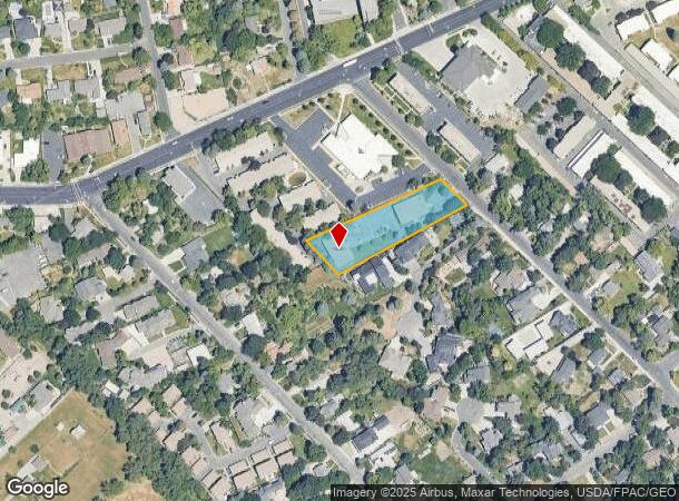
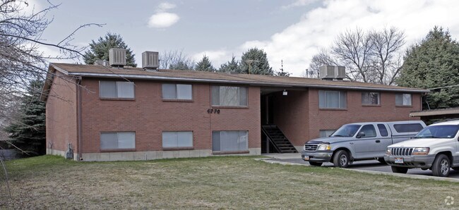
Property Record
4768 S Bonair St, Salt Lake City, UT 84117

NEARBY LISTINGS FOR SALE OR LEASE
Property Detail
4768 S Bonair St
22-10-127-020-0000
COM 1161.8 FT W & 336.8 FT S & S 45^54 E 399.11 FT FR NE COR OF NW 1/4 OF SEC 10, T 2S, R 1E, S L M; S 65^39 W 435.2FT; S 44^18 E 121 FT; N 61^52 E 428.53 FT; N 45^54 W 91.87 FT TO BEG. 1.0 AC 4190-0223 5564-1740 6243-1000 6505-0393,0395 9340-1294 10
Apartment
Salt Lake
X
Utah
49035C0312G
m
2024
1.08 AC
2025
Holladay
110800
Salt Lake City
14,560 SF
Salt Lake City, UT
DEMOGRAPHICS near 4768 S Bonair St
1 Mile
3 Mile
5 Mile
2024 Total Population
14,002
113,171
273,540
2029 Population
14,105
113,914
276,203
Pop Growth 2024-2029
+ 0.74%
+ 0.66%
+ 0.97%
Average Age
40
41
39
2024 Total Households
5,282
44,346
108,193
HH Growth 2024-2029
+ 0.66%
+ 0.56%
+ 0.96%
Median Household Inc
$87,271
$85,497
$79,008
Avg Household Size
2.60
2.50
2.40
2024 Avg HH Vehicles
2.00
2.00
2.00
Median Home Value
$741,956
$609,784
$529,423
Median Year Built
1969
1972
1974
Nearby Places
Map Layers
Map Styles
 Street
 Aerial
- Restaurants
- Banks
- Shops
- Fitness
- Groceries
PUBLIC TRANSPORTATION
AIRPORT
Salt Lake City International
DRIVE
WALK
Distance
Salt Lake City International
24 min
15.8 mi
Freight Ports
Port of Stockton
DRIVE
WALK
Distance
Port of Stockton
725 min
706.2 mi
Nearby Properties
Address
Land Use
TOTAL SIZE
Lot Size
Zoning
Address
Land Use
TOTAL SIZE
Lot Size
Zoning
207,140 SF
23.06 AC
P
Address
Land Use
TOTAL SIZE
Lot Size
Zoning
257,003 SF
25.87 AC
1108
Address
Land Use
TOTAL SIZE
Lot Size
Zoning
691,463 SF
17.80 AC
RM
Address
Land Use
TOTAL SIZE
Lot Size
Zoning
524,108 SF
34.46 AC
RM
Address
Land Use
TOTAL SIZE
Lot Size
Zoning
302,944 SF
5.47 AC
Address
Land Use
TOTAL SIZE
Lot Size
Zoning
412,006 SF
1.70 AC
C3
Address
Land Use
TOTAL SIZE
Lot Size
Zoning
225,849 SF
16.36 AC
RM-ZC
Address
Land Use
TOTAL SIZE
Lot Size
Zoning
21,057 SF
17.96 AC
RM20
Address
Land Use
TOTAL SIZE
Lot Size
Zoning
125,518 SF
11.03 AC
RMZC
Address
Land Use
TOTAL SIZE
Lot Size
Zoning
371,607 SF
10.77 AC
A-1
Address
Land Use
TOTAL SIZE
Lot Size
Zoning
33,164 SF
6.88 AC
RM
Address
Land Use
TOTAL SIZE
Lot Size
Zoning
37,563 SF
15.34 AC
RM20
Address
Land Use
TOTAL SIZE
Lot Size
Zoning
28,078 SF
15.33 AC
RM-10
Address
Land Use
TOTAL SIZE
Lot Size
Zoning
241,418 SF
8.84 AC
ORD
Address
Land Use
TOTAL SIZE
Lot Size
Zoning
299,673 SF
2.16 AC
C3
Address
Land Use
TOTAL SIZE
Lot Size
Zoning
99,702 SF
12.73 AC
R-M
Address
Land Use
TOTAL SIZE
Lot Size
Zoning
84,246 SF
6.51 AC
RM
Address
Land Use
TOTAL SIZE
Lot Size
Zoning
317,495 SF
2.75 AC
O-R-D
Address
Land Use
TOTAL SIZE
Lot Size
Zoning
77,051 SF
8.34 AC
RM/ZC
Address
Land Use
TOTAL SIZE
Lot Size
Zoning
433,385 SF
3.64 AC
R/M-U
Address
Land Use
TOTAL SIZE
Lot Size
Zoning
132,942 SF
18 AC
1108
Address
Land Use
TOTAL SIZE
Lot Size
Zoning
150,570 SF
12.76 AC
ORD
Address
Land Use
TOTAL SIZE
Lot Size
Zoning
71,504 SF
7.11 AC
R-1-10
Address
Land Use
TOTAL SIZE
Lot Size
Zoning
97,657 SF
6.66 AC
RM
Address
Land Use
TOTAL SIZE
Lot Size
Zoning
106,467 SF
4.41 AC
2000
Address
Land Use
TOTAL SIZE
Lot Size
Zoning
49,722 SF
7.59 AC
RM-ZC
Address
Land Use
TOTAL SIZE
Lot Size
Zoning
176,372 SF
3.68 AC
ORD
Address
Land Use
TOTAL SIZE
Lot Size
Zoning
152,184 SF
4.40 AC
ORD
Address
Land Use
TOTAL SIZE
Lot Size
Zoning
74,394 SF
9.27 AC
RM
Address
Land Use
TOTAL SIZE
Lot Size
Zoning
125,789 SF
24.19 AC
1110
The World's #1 Commercial Real Estate Marketplace
Connect with us
© 2025 CoStar Group
The information above has been obtained from sources believed reliable. While we do not doubt its accuracy we have not verified it and make no guarantee, warranty or representation about it. It is your responsibility to independently confirm its accuracy and completeness. Any projections, opinions, assumptions, or estimates used are for example only and do not represent the current or future performance of the property. The value of this transaction to you depends on tax and other factors which should be evaluated by your tax, financial, and legal advisors. You and your advisors should conduct a careful, independent investigation of the property to determine to your satisfaction the suitability of the property for your needs.