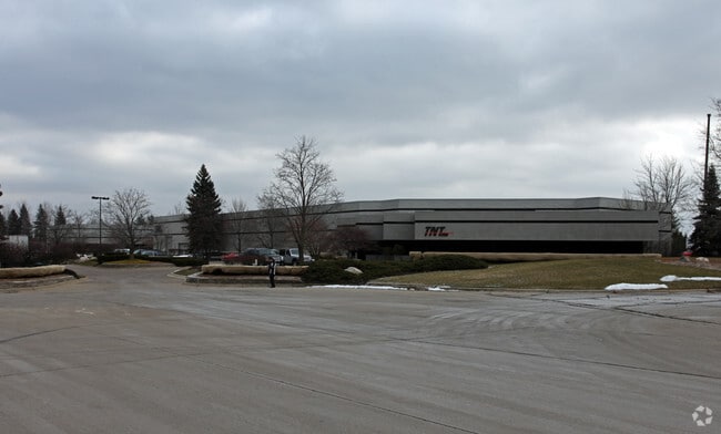
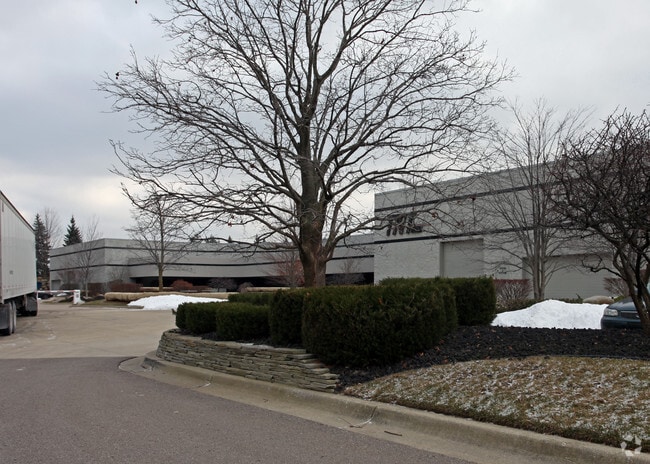
Property Record
47689 E Anchor Ct, Plymouth, MI 48170

NEARBY LISTINGS FOR SALE OR LEASE
Property Detail
47689 E Anchor Ct
Detroit-Warren-Dearborn, MI
Metro West Technology Park
78-008-01-0005-301
20B5A 13 THE WLY PT OF LOT 5 DESC AS BEG AT THE SW COR OF LOT 5 TH N 00D 40M 00S W 273.13FT TH N 89D 38M 11S E 270.00FT TH S 00D 40M 00S E 271.70FT TH S 89D 20M 00S W 270.00FT POB ALSO LOT 13 3.87AC K3.87
Manufacturinglight
Wayne
X
Michigan
26163C0020E
3,5,13
2025
3.87 AC
2025
Livonia
561700
Detroit
57,604 SF
DEMOGRAPHICS near 47689 E Anchor Ct
1 Mile
3 Mile
5 Mile
2024 Total Population
2,590
39,097
115,321
2029 Population
2,473
37,427
110,886
Pop Growth 2024-2029
(4.52%)
(4.27%)
(3.85%)
Average Age
43
43
43
2024 Total Households
957
14,862
45,770
HH Growth 2024-2029
(4.49%)
(4.25%)
(3.81%)
Median Household Inc
$123,403
$143,930
$116,927
Avg Household Size
2.70
2.60
2.50
2024 Avg HH Vehicles
2.00
2.00
2.00
Median Home Value
$471,282
$472,879
$377,774
Median Year Built
1995
1989
1979
Nearby Places
Map Layers
Map Styles
 Street
 Aerial
- Restaurants
- Banks
- Shops
- Fitness
- Groceries
PUBLIC TRANSPORTATION
AIRPORT
Detroit Metro Wayne County
DRIVE
WALK
Distance
Detroit Metro Wayne County
29 min
22.9 mi
Windsor International
DRIVE
WALK
Distance
Windsor International
55 min
37.4 mi
Freight Ports
Port of Toledo
DRIVE
WALK
Distance
Port of Toledo
79 min
64.5 mi
Nearby Properties
Address
Land Use
TOTAL SIZE
Lot Size
Zoning
Address
Land Use
TOTAL SIZE
Lot Size
Zoning
334,346 SF
55.65 AC
TAR
Address
Land Use
TOTAL SIZE
Lot Size
Zoning
306,061 SF
26.36 AC
TAR
Address
Land Use
TOTAL SIZE
Lot Size
Zoning
117.35 AC
Address
Land Use
TOTAL SIZE
Lot Size
Zoning
225,164 SF
25.66 AC
IND
Address
Land Use
TOTAL SIZE
Lot Size
Zoning
99,826 SF
ORT
Address
Land Use
TOTAL SIZE
Lot Size
Zoning
123,225 SF
9 AC
CJ/ARC
Address
Land Use
TOTAL SIZE
Lot Size
Zoning
78,164 SF
5.51 AC
PUD
Address
Land Use
TOTAL SIZE
Lot Size
Zoning
103,075 SF
8.15 AC
PUD
Address
Land Use
TOTAL SIZE
Lot Size
Zoning
135,586 SF
8.08 AC
IND
Address
Land Use
TOTAL SIZE
Lot Size
Zoning
191,759 SF
26.11 AC
ORT
Address
Land Use
TOTAL SIZE
Lot Size
Zoning
285,680 SF
IND
Address
Land Use
TOTAL SIZE
Lot Size
Zoning
122,116 SF
4.99 AC
PUD
Address
Land Use
TOTAL SIZE
Lot Size
Zoning
101,121 SF
17.52 AC
C-2
Address
Land Use
TOTAL SIZE
Lot Size
Zoning
233,568 SF
11.96 AC
IND
Address
Land Use
TOTAL SIZE
Lot Size
Zoning
307,495 SF
15.76 AC
IND
Address
Land Use
TOTAL SIZE
Lot Size
Zoning
37,528 SF
0.55 AC
B-2
Address
Land Use
TOTAL SIZE
Lot Size
Zoning
949,993 SF
98.83 AC
IND
Address
Land Use
TOTAL SIZE
Lot Size
Zoning
245 SF
78.71 AC
RM
Address
Land Use
TOTAL SIZE
Lot Size
Zoning
87,513 SF
3.14 AC
MR
Address
Land Use
TOTAL SIZE
Lot Size
Zoning
68,687 SF
15 AC
TAR
Address
Land Use
TOTAL SIZE
Lot Size
Zoning
37,410 SF
2.37 AC
IND
Address
Land Use
TOTAL SIZE
Lot Size
Zoning
14,280 SF
12.74 AC
R-2-A
Address
Land Use
TOTAL SIZE
Lot Size
Zoning
69,772 SF
3.34 AC
PUD
Address
Land Use
TOTAL SIZE
Lot Size
Zoning
162,174 SF
12.70 AC
PUD
Address
Land Use
TOTAL SIZE
Lot Size
Zoning
142,068 SF
30.42 AC
IND
Address
Land Use
TOTAL SIZE
Lot Size
Zoning
Address
Land Use
TOTAL SIZE
Lot Size
Zoning
106,239 SF
6.49 AC
IND
Address
Land Use
TOTAL SIZE
Lot Size
Zoning
528,100 SF
34.16 AC
I-1
Address
Land Use
TOTAL SIZE
Lot Size
Zoning
59,172 SF
1.13 AC
B-2
Address
Land Use
TOTAL SIZE
Lot Size
Zoning
73,313 SF
15.31 AC
TAR
The World's #1 Commercial Real Estate Marketplace
Connect with us
© 2026 CoStar Group
The information above has been obtained from sources believed reliable. While we do not doubt its accuracy we have not verified it and make no guarantee, warranty or representation about it. It is your responsibility to independently confirm its accuracy and completeness. Any projections, opinions, assumptions, or estimates used are for example only and do not represent the current or future performance of the property. The value of this transaction to you depends on tax and other factors which should be evaluated by your tax, financial, and legal advisors. You and your advisors should conduct a careful, independent investigation of the property to determine to your satisfaction the suitability of the property for your needs.