Property Record
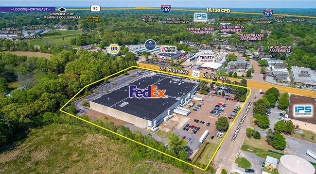
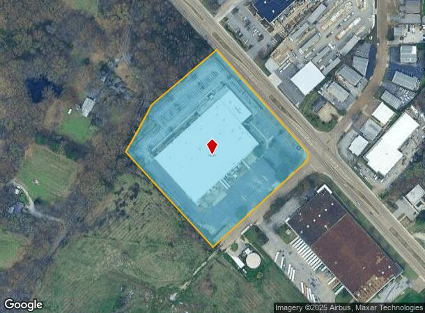
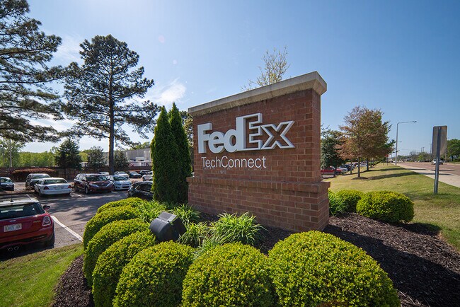
477 Distribution Pky, Collierville, TN 38017

NEARBY LISTINGS FOR SALE OR LEASE
-
-
View all Collierville listings for sale on LoopNet.com
Property Detail
477 Distribution Pky
C0-244-A-00068
SW SIDE HWY 72 436.62 FT SE OF SYCAMORE RD SEE MAP GRID 205 F
Warehouse
Shelby
X
Tennessee
47157C0495G
9.08 AC
2023
Southeast
2025
Memphis
021620
Memphis, TN-MS-AR
125,993 SF
DEMOGRAPHICS near 477 Distribution Pky
1 Mile
3 Mile
5 Mile
2024 Total Population
2,506
31,623
52,930
2029 Population
2,467
31,035
52,143
Pop Growth 2024-2029
(1.56%)
(1.86%)
(1.49%)
Average Age
40
40
40
2024 Total Households
940
11,498
18,989
HH Growth 2024-2029
(1.70%)
(1.99%)
(1.56%)
Median Household Inc
$64,722
$115,228
$123,582
Avg Household Size
2.60
2.70
2.80
2024 Avg HH Vehicles
2.00
2.00
2.00
Median Home Value
$415,086
$360,668
$384,485
Median Year Built
1969
1993
1996
Nearby Places
Map Layers
Map Styles
 Street
 Aerial
- Restaurants
- Banks
- Shops
- Fitness
- Groceries
PUBLIC TRANSPORTATION
AIRPORT
Memphis International
DRIVE
WALK
Distance
Memphis International
32 min
21.2 mi
Freight Ports
Port of Shreveport
DRIVE
WALK
Distance
Port of Shreveport
434 min
395.0 mi
SALE & LEASE HISTORY
LISTING DATE
SALE/LEASE

Jun 09, 2021
For Sale
Nearby Properties
Address
Land Use
TOTAL SIZE
Lot Size
Zoning
Address
Land Use
TOTAL SIZE
Lot Size
Zoning
221,465 SF
63.45 AC
R-3
Address
Land Use
TOTAL SIZE
Lot Size
Zoning
103,960 SF
47.52 AC
R-3
Address
Land Use
TOTAL SIZE
Lot Size
Zoning
88,989 SF
6.91 AC
PD
Address
Land Use
TOTAL SIZE
Lot Size
Zoning
241,626 SF
19.59 AC
Address
Land Use
TOTAL SIZE
Lot Size
Zoning
81,518 SF
4.22 AC
R-3
Address
Land Use
TOTAL SIZE
Lot Size
Zoning
115,753 SF
21.54 AC
R-1
Address
Land Use
TOTAL SIZE
Lot Size
Zoning
40,257 SF
24.68 AC
R-1
Address
Land Use
TOTAL SIZE
Lot Size
Zoning
98,107 SF
10.09 AC
RI
Address
Land Use
TOTAL SIZE
Lot Size
Zoning
167,121 SF
13.56 AC
AG
Address
Land Use
TOTAL SIZE
Lot Size
Zoning
28,280 SF
3.47 AC
R-1
Address
Land Use
TOTAL SIZE
Lot Size
Zoning
67,592 SF
18.31 AC
PD
Address
Land Use
TOTAL SIZE
Lot Size
Zoning
223,103 SF
19.25 AC
SCC
Address
Land Use
TOTAL SIZE
Lot Size
Zoning
17,812 SF
25 AC
R-3
Address
Land Use
TOTAL SIZE
Lot Size
Zoning
16,655 SF
5.69 AC
SCC
Address
Land Use
TOTAL SIZE
Lot Size
Zoning
40,170 SF
23.21 AC
AG
Address
Land Use
TOTAL SIZE
Lot Size
Zoning
68,175 SF
20.58 AC
R-1
Address
Land Use
TOTAL SIZE
Lot Size
Zoning
916,949 SF
100.43 AC
GI
Address
Land Use
TOTAL SIZE
Lot Size
Zoning
108,234 SF
13.48 AC
SCC
Address
Land Use
TOTAL SIZE
Lot Size
Zoning
397,593 SF
62.35 AC
R-1
Address
Land Use
TOTAL SIZE
Lot Size
Zoning
397,593 SF
61.46 AC
R-1
Address
Land Use
TOTAL SIZE
Lot Size
Zoning
72.43 AC
R-1
Address
Land Use
TOTAL SIZE
Lot Size
Zoning
75,975 SF
13.09 AC
SCC
Address
Land Use
TOTAL SIZE
Lot Size
Zoning
91,006 SF
7.97 AC
PD
Address
Land Use
TOTAL SIZE
Lot Size
Zoning
73,377 SF
6.56 AC
PD
Address
Land Use
TOTAL SIZE
Lot Size
Zoning
256,456 SF
51.05 AC
M2
Address
Land Use
TOTAL SIZE
Lot Size
Zoning
147,342 SF
4.93 AC
R-1
Address
Land Use
TOTAL SIZE
Lot Size
Zoning
197,121 SF
22.07 AC
SCC
Address
Land Use
TOTAL SIZE
Lot Size
Zoning
54,424 SF
6.28 AC
R-1
Address
Land Use
TOTAL SIZE
Lot Size
Zoning
36,800 SF
18.50 AC
Address
Land Use
TOTAL SIZE
Lot Size
Zoning
155.29 AC
CA
The World's #1 Commercial Real Estate Marketplace
Connect with us
© 2026 CoStar Group
The information above has been obtained from sources believed reliable. While we do not doubt its accuracy we have not verified it and make no guarantee, warranty or representation about it. It is your responsibility to independently confirm its accuracy and completeness. Any projections, opinions, assumptions, or estimates used are for example only and do not represent the current or future performance of the property. The value of this transaction to you depends on tax and other factors which should be evaluated by your tax, financial, and legal advisors. You and your advisors should conduct a careful, independent investigation of the property to determine to your satisfaction the suitability of the property for your needs.