Property Record
477 E Altamonte Dr, Altamonte Springs, FL 32701


NEARBY LISTINGS FOR SALE OR LEASE
Property Detail
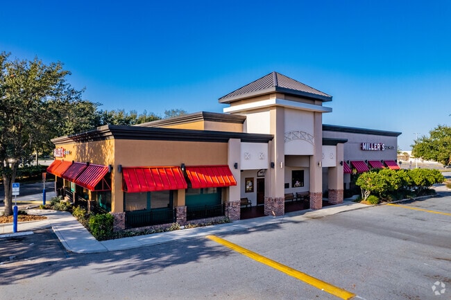
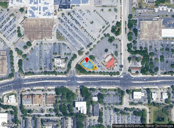
477 E Altamonte Dr
13-21-29-300-005G-0000
SEC 13 TWP 21S RGE 29E FROM W 1/4 COR RUN N 791.21 FT E 653.28 FT N 120 FT N 45 DEG 41 MIN 51 SEC E 56.34 FT S 44 DEG 18 MIN 09 SEC E 49.81 FT TO POB RUN N 45 DEG 39 MIN 47 SEC E 112.62 FT S 44 DEG 03 MIN 55 SEC E 141.63 FT S 44 DEG 39 MIN 07 SEC W 2
Restaurantbuilding
Seminole
X
Florida
12095C0145F
0.36 AC
2025
Altamonte/Douglas
2025
Orlando
021901
Orlando-Kissimmee-Sanford, FL
9,942 SF
DEMOGRAPHICS near 477 E Altamonte Dr
1 mile
3 mile
5 mile
2024 Total Population
14,555
98,717
248,024
2029 Population
15,322
103,157
258,154
Pop Growth 2024-2029
+ 5.27%
+ 4.50%
+ 4.08%
Average Age
43
41
41
2024 Total Households
7,504
42,823
103,401
HH Growth 2024-2029
+ 5.56%
+ 4.64%
+ 4.28%
Median Household Inc
$60,284
$61,700
$63,869
Avg Household Size
1.90
2.20
2.30
2024 Avg HH Vehicles
1.00
2.00
2.00
Median Home Value
$247,894
$308,308
$309,445
Median Year Built
1980
1979
1981
Nearby Places
Map Layers
Map Styles
 Street
 Aerial
Transit
 Traffic
 Biking
Places
Listings with unknown addresses are not visible on the map
- Restaurants
- Banks
- Shops
- Fitness
- Groceries
PUBLIC TRANSPORTATION
COMMUTER RAIL
Drive
Walk
Distance
4 min
1.4 mi
Drive
Walk
Distance
8 min
3.4 mi
AIRPORT
Orlando Sanford International
Drive
Walk
Distance
Orlando Sanford International
27 min
13.9 mi
Orlando International
Drive
Walk
Distance
Orlando International
33 min
19.0 mi
Freight Ports
Port Canaveral
Drive
Walk
Distance
Port Canaveral
80 min
61.4 mi
Nearby Properties
Address
Land Use
TOTAL SIZE
Lot Size
Zoning
Address
Land Use
TOTAL SIZE
Lot Size
Zoning
1,009,074 SF
37.77 AC
PD
Address
Land Use
TOTAL SIZE
Lot Size
Zoning
630,861 SF
31.68 AC
PUDMO
Address
Land Use
TOTAL SIZE
Lot Size
Zoning
88,256 SF
39.64 AC
MOC3
Address
Land Use
TOTAL SIZE
Lot Size
Zoning
34,430 SF
19.99 AC
Address
Land Use
TOTAL SIZE
Lot Size
Zoning
423,270 SF
3.45 AC
MOC3
Address
Land Use
TOTAL SIZE
Lot Size
Zoning
467,832 SF
20.10 AC
PD
Address
Land Use
TOTAL SIZE
Lot Size
Zoning
21.25 AC
GC
Address
Land Use
TOTAL SIZE
Lot Size
Zoning
1,674 SF
10.53 AC
R3
Address
Land Use
TOTAL SIZE
Lot Size
Zoning
357 SF
17.05 AC
Address
Land Use
TOTAL SIZE
Lot Size
Zoning
130,246 SF
71.01 AC
PUD
Address
Land Use
TOTAL SIZE
Lot Size
Zoning
1,158 SF
17.22 AC
Address
Land Use
TOTAL SIZE
Lot Size
Zoning
656,009 SF
5.59 AC
DM
Address
Land Use
TOTAL SIZE
Lot Size
Zoning
391,714 SF
42.59 AC
A1
Address
Land Use
TOTAL SIZE
Lot Size
Zoning
Address
Land Use
TOTAL SIZE
Lot Size
Zoning
563,546 SF
0.61 AC
DM
Address
Land Use
TOTAL SIZE
Lot Size
Zoning
206 SF
1.43 AC
VMU
Address
Land Use
TOTAL SIZE
Lot Size
Zoning
381,557 SF
10.09 AC
PD
Address
Land Use
TOTAL SIZE
Lot Size
Zoning
555,833 SF
3.65 AC
DM
Address
Land Use
TOTAL SIZE
Lot Size
Zoning
400 SF
13.82 AC
R1AA
Address
Land Use
TOTAL SIZE
Lot Size
Zoning
5,256 SF
1.10 AC
PUDRES
Address
Land Use
TOTAL SIZE
Lot Size
Zoning
540 SF
7.72 AC
GC
Address
Land Use
TOTAL SIZE
Lot Size
Zoning
231,070 SF
35.59 AC
MOR2
Address
Land Use
TOTAL SIZE
Lot Size
Zoning
11,392 SF
8.44 AC
Address
Land Use
TOTAL SIZE
Lot Size
Zoning
631,978 SF
7 AC
PD
Address
Land Use
TOTAL SIZE
Lot Size
Zoning
385,111 SF
12.39 AC
PD
Address
Land Use
TOTAL SIZE
Lot Size
Zoning
1,170 SF
17.75 AC
A1
Address
Land Use
TOTAL SIZE
Lot Size
Zoning
456 SF
9.56 AC
Address
Land Use
TOTAL SIZE
Lot Size
Zoning
5,924 SF
17.38 AC
R1A
Address
Land Use
TOTAL SIZE
Lot Size
Zoning
1,428 SF
8.56 AC
MOR3
Address
Land Use
TOTAL SIZE
Lot Size
Zoning
377,321 SF
20.58 AC
R3A
The World's #1 Commercial Real Estate Marketplace
Connect with us
© 2026 CoStar Group
The information above has been obtained from sources believed reliable. While we do not doubt its accuracy we have not verified it and make no guarantee, warranty or representation about it. It is your responsibility to independently confirm its accuracy and completeness. Any projections, opinions, assumptions, or estimates used are for example only and do not represent the current or future performance of the property. The value of this transaction to you depends on tax and other factors which should be evaluated by your tax, financial, and legal advisors. You and your advisors should conduct a careful, independent investigation of the property to determine to your satisfaction the suitability of the property for your needs.