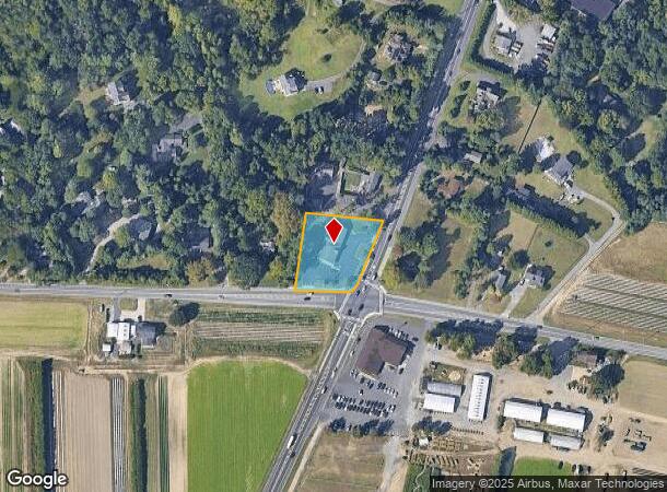
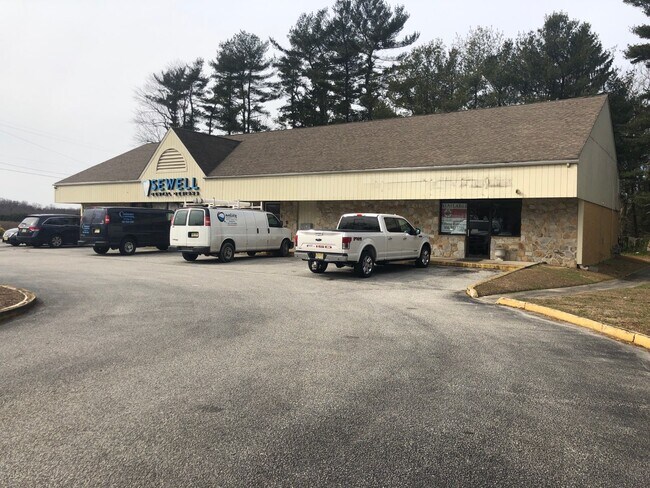
Property Record
477 Greentree Rd, Sewell, NJ 08080


NEARBY LISTINGS FOR SALE OR LEASE
Property Detail
477 Greentree Rd
Philadelphia-Camden-Wilmington, PA-NJ-DE-MD
(4264)SQ. FT.
18-00053-0000-00015-10
Gloucester
Regionalshoppingcenterormallwithanchorstore
New Jersey
X
15.10
34015C0201E
0.92 AC
2024
Gloucester County
2025
Philadelphia
501208
DEMOGRAPHICS near 477 Greentree Rd
1 mile
3 mile
5 mile
2024 Total Population
4,488
71,803
134,764
2029 Population
4,618
74,339
138,673
Pop Growth 2024-2029
+ 2.90%
+ 3.53%
+ 2.90%
Average Age
44
40
40
2024 Total Households
1,747
24,640
47,520
HH Growth 2024-2029
+ 2.92%
+ 3.82%
+ 3.07%
Median Household Inc
$117,002
$100,025
$99,911
Avg Household Size
2.60
2.60
2.60
2024 Avg HH Vehicles
2.00
2.00
2.00
Median Home Value
$276,607
$271,023
$272,441
Median Year Built
1983
1979
1981
Nearby Places
Map Layers
Map Styles
 Street
 Aerial
Transit
 Traffic
 Biking
Places
Listings with unknown addresses are not visible on the map
- Restaurants
- Banks
- Shops
- Fitness
- Groceries
PUBLIC TRANSPORTATION
COMMUTER RAIL
Lindenwold (NJT) (Atlantic City Line - NJ Transit Commuter Rail (NJ Transit))
Drive
Walk
Distance
Lindenwold (NJT) (Atlantic City Line - NJ Transit Commuter Rail (NJ Transit))
20 min
10.0 mi
AIRPORT
Philadelphia International
Drive
Walk
Distance
Philadelphia International
39 min
22.8 mi
Atlantic City International
Drive
Walk
Distance
Atlantic City International
72 min
40.9 mi
Freight Ports
Broadway Terminal - Pier 5
Drive
Walk
Distance
Broadway Terminal - Pier 5
23 min
14.3 mi
SALE & LEASE HISTORY
LISTING DATE
SALE/LEASE

Feb 13, 2020
For Lease
Nearby Properties
Address
Land Use
TOTAL SIZE
Lot Size
Zoning
Address
Land Use
TOTAL SIZE
Lot Size
Zoning
96.68 AC
P
Address
Land Use
TOTAL SIZE
Lot Size
Zoning
14.21 AC
INS
Address
Land Use
TOTAL SIZE
Lot Size
Zoning
3.34 AC
R3
Address
Land Use
TOTAL SIZE
Lot Size
Zoning
4.41 AC
Address
Land Use
TOTAL SIZE
Lot Size
Zoning
Address
Land Use
TOTAL SIZE
Lot Size
Zoning
Address
Land Use
TOTAL SIZE
Lot Size
Zoning
38.92 AC
HC
Address
Land Use
TOTAL SIZE
Lot Size
Zoning
4.52 AC
P
Address
Land Use
TOTAL SIZE
Lot Size
Zoning
46.38 AC
P
Address
Land Use
TOTAL SIZE
Lot Size
Zoning
Address
Land Use
TOTAL SIZE
Lot Size
Zoning
69.68 AC
INS
Address
Land Use
TOTAL SIZE
Lot Size
Zoning
38.57 AC
INS
Address
Land Use
TOTAL SIZE
Lot Size
Zoning
Address
Land Use
TOTAL SIZE
Lot Size
Zoning
23.27 AC
C5
Address
Land Use
TOTAL SIZE
Lot Size
Zoning
26.35 AC
R4
Address
Land Use
TOTAL SIZE
Lot Size
Zoning
4.89 AC
RA
Address
Land Use
TOTAL SIZE
Lot Size
Zoning
28.68 AC
HC
Address
Land Use
TOTAL SIZE
Lot Size
Zoning
1.77 AC
Address
Land Use
TOTAL SIZE
Lot Size
Zoning
1.29 AC
Address
Land Use
TOTAL SIZE
Lot Size
Zoning
Address
Land Use
TOTAL SIZE
Lot Size
Zoning
Address
Land Use
TOTAL SIZE
Lot Size
Zoning
15.98 AC
PC
Address
Land Use
TOTAL SIZE
Lot Size
Zoning
22.31 AC
C5
Address
Land Use
TOTAL SIZE
Lot Size
Zoning
14.57 AC
P
Address
Land Use
TOTAL SIZE
Lot Size
Zoning
2.68 AC
P
Address
Land Use
TOTAL SIZE
Lot Size
Zoning
1.52 AC
Address
Land Use
TOTAL SIZE
Lot Size
Zoning
1,316 SF
16.04 AC
PC
Address
Land Use
TOTAL SIZE
Lot Size
Zoning
14.92 AC
HC
Address
Land Use
TOTAL SIZE
Lot Size
Zoning
7.04 AC
INS
Address
Land Use
TOTAL SIZE
Lot Size
Zoning
7.57 AC
P
The World's #1 Commercial Real Estate Marketplace
Connect with us
© 2026 CoStar Group
The information above has been obtained from sources believed reliable. While we do not doubt its accuracy we have not verified it and make no guarantee, warranty or representation about it. It is your responsibility to independently confirm its accuracy and completeness. Any projections, opinions, assumptions, or estimates used are for example only and do not represent the current or future performance of the property. The value of this transaction to you depends on tax and other factors which should be evaluated by your tax, financial, and legal advisors. You and your advisors should conduct a careful, independent investigation of the property to determine to your satisfaction the suitability of the property for your needs.