Property Record
E S Hard Scrabble Rd, Columbia, SC 29229
Current Lease Availabilities
NEARBY LISTINGS FOR SALE OR LEASE
Property Detail
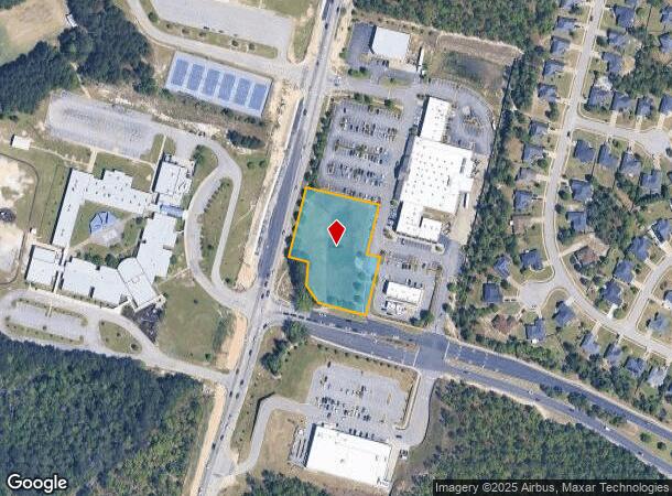
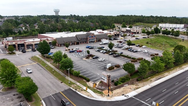
E S Hard Scrabble Rd
Columbia, SC
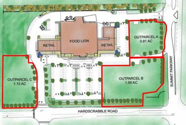
Summit Commons
20300-05-08
PT OUTPARCEL B 214.4X208.2X148.7X39.5X175X 138.3X60.1X68.1X54.1 #SU
Commercialnec
Richland
X
South Carolina
45079C0141L
1.55 AC
2025
Northeast Columbia
2024
Columbia
011417
DEMOGRAPHICS near E S Hard Scrabble Rd
1 Mile
3 Mile
5 Mile
2024 Total Population
11,030
61,769
102,403
2029 Population
11,185
62,640
104,113
Pop Growth 2024-2029
+ 1.41%
+ 1.41%
+ 1.67%
Average Age
37
37
38
2024 Total Households
4,292
22,619
38,735
HH Growth 2024-2029
+ 1.26%
+ 1.45%
+ 1.72%
Median Household Inc
$63,002
$74,227
$72,392
Avg Household Size
2.50
2.70
2.60
2024 Avg HH Vehicles
2.00
2.00
2.00
Median Home Value
$182,595
$205,789
$215,745
Median Year Built
2004
2003
2002
Nearby Places
Map Layers
Map Styles
 Street
 Aerial
- Restaurants
- Banks
- Shops
- Fitness
- Groceries
PUBLIC TRANSPORTATION
AIRPORT
Columbia Metro
DRIVE
WALK
Distance
Columbia Metro
46 min
27.0 mi
Freight Ports
North Charleston Terminal
DRIVE
WALK
Distance
North Charleston Terminal
145 min
124.1 mi
Nearby Properties
Address
Land Use
TOTAL SIZE
Lot Size
Zoning
Address
Land Use
TOTAL SIZE
Lot Size
Zoning
231,760 SF
23.84 AC
M-1
Address
Land Use
TOTAL SIZE
Lot Size
Zoning
333,002 SF
8.39 AC
GC
Address
Land Use
TOTAL SIZE
Lot Size
Zoning
244,269 SF
9.54 AC
GC
Address
Land Use
TOTAL SIZE
Lot Size
Zoning
563.44 AC
OI
Address
Land Use
TOTAL SIZE
Lot Size
Zoning
309,478 SF
8.87 AC
PDD
Address
Land Use
TOTAL SIZE
Lot Size
Zoning
306,612 SF
20.94 AC
GC
Address
Land Use
TOTAL SIZE
Lot Size
Zoning
301,627 SF
25.08 AC
PDD
Address
Land Use
TOTAL SIZE
Lot Size
Zoning
232,148 SF
14.16 AC
PDD
Address
Land Use
TOTAL SIZE
Lot Size
Zoning
462,800 SF
104.82 AC
M-1
Address
Land Use
TOTAL SIZE
Lot Size
Zoning
147,916 SF
4.69 AC
OI
Address
Land Use
TOTAL SIZE
Lot Size
Zoning
91,672 SF
12.18 AC
GC
Address
Land Use
TOTAL SIZE
Lot Size
Zoning
66,821 SF
6.32 AC
OI
Address
Land Use
TOTAL SIZE
Lot Size
Zoning
275,753 SF
26.21 AC
HI
Address
Land Use
TOTAL SIZE
Lot Size
Zoning
73,192 SF
6.12 AC
GC
Address
Land Use
TOTAL SIZE
Lot Size
Zoning
148,809 SF
17.52 AC
M-1
Address
Land Use
TOTAL SIZE
Lot Size
Zoning
129,017 SF
14.70 AC
PDD
Address
Land Use
TOTAL SIZE
Lot Size
Zoning
143,072 SF
12.61 AC
PDD
Address
Land Use
TOTAL SIZE
Lot Size
Zoning
75,893 SF
10 AC
PDD
Address
Land Use
TOTAL SIZE
Lot Size
Zoning
68,091 SF
4.35 AC
OI
Address
Land Use
TOTAL SIZE
Lot Size
Zoning
125,894 SF
7.77 AC
PDD
Address
Land Use
TOTAL SIZE
Lot Size
Zoning
73,901 SF
8.83 AC
PUD
Address
Land Use
TOTAL SIZE
Lot Size
Zoning
37,971 SF
8.40 AC
PDD
Address
Land Use
TOTAL SIZE
Lot Size
Zoning
117,832 SF
10.82 AC
PDD
Address
Land Use
TOTAL SIZE
Lot Size
Zoning
86,776 SF
6.43 AC
OI
Address
Land Use
TOTAL SIZE
Lot Size
Zoning
75,470 SF
10.81 AC
GC
Address
Land Use
TOTAL SIZE
Lot Size
Zoning
42,938 SF
7.30 AC
HI
Address
Land Use
TOTAL SIZE
Lot Size
Zoning
103,719 SF
4.05 AC
RM-HD
Address
Land Use
TOTAL SIZE
Lot Size
Zoning
74,014 SF
22.02 AC
HI
Address
Land Use
TOTAL SIZE
Lot Size
Zoning
2,574 SF
5.83 AC
GC
Address
Land Use
TOTAL SIZE
Lot Size
Zoning
23,660 SF
14.87 AC
RS-LD
The World's #1 Commercial Real Estate Marketplace
Connect with us
© 2026 CoStar Group
The information above has been obtained from sources believed reliable. While we do not doubt its accuracy we have not verified it and make no guarantee, warranty or representation about it. It is your responsibility to independently confirm its accuracy and completeness. Any projections, opinions, assumptions, or estimates used are for example only and do not represent the current or future performance of the property. The value of this transaction to you depends on tax and other factors which should be evaluated by your tax, financial, and legal advisors. You and your advisors should conduct a careful, independent investigation of the property to determine to your satisfaction the suitability of the property for your needs.