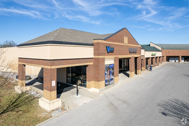
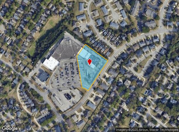
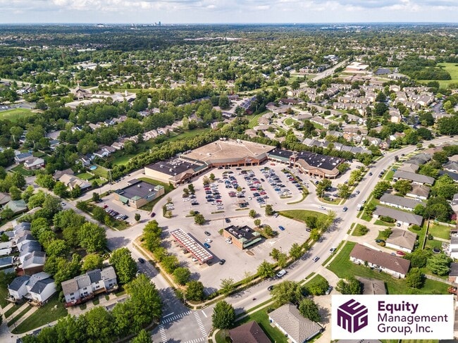
Property Record
4770 Hartland Pkwy, Lexington, KY 40515
NEARBY LISTINGS FOR SALE OR LEASE
Property Detail
4770 Hartland Pkwy
Lexington-Fayette, KY
Meadow Creek
38056590
L-391 MEADOW CREEK UNIT 8 LOT 1-F; BOOK: 2183 PAGE: 584
Stripcommercialcenter
Fayette
X
Kentucky
2100670228F
1-f
2025
2.02 AC
2025
East Lexington/Fayette
004005
Lexington/Fayette
26,380 SF
DEMOGRAPHICS near 4770 Hartland Pkwy
1 Mile
3 Mile
5 Mile
2024 Total Population
13,426
77,027
156,940
2029 Population
13,289
76,859
156,490
Pop Growth 2024-2029
(1.02%)
(0.22%)
(0.29%)
Average Age
39
38
38
2024 Total Households
5,834
33,826
67,227
HH Growth 2024-2029
(1.05%)
(0.27%)
(0.35%)
Median Household Inc
$67,212
$60,800
$65,155
Avg Household Size
2.20
2.20
2.30
2024 Avg HH Vehicles
2.00
2.00
2.00
Median Home Value
$257,240
$234,742
$262,933
Median Year Built
1986
1983
1983
Nearby Places
Map Layers
Map Styles
 Street
 Aerial
- Restaurants
- Banks
- Shops
- Fitness
- Groceries
PUBLIC TRANSPORTATION
AIRPORT
Blue Grass
DRIVE
WALK
Distance
Blue Grass
24 min
12.9 mi
Freight Ports
Port of Toledo
DRIVE
WALK
Distance
Port of Toledo
345 min
296.5 mi
Nearby Properties
Address
Land Use
TOTAL SIZE
Lot Size
Zoning
Address
Land Use
TOTAL SIZE
Lot Size
Zoning
76,441 SF
63.86 AC
A-U
Address
Land Use
TOTAL SIZE
Lot Size
Zoning
4,299 SF
18.43 AC
R-4
Address
Land Use
TOTAL SIZE
Lot Size
Zoning
8,001 SF
32.59 AC
MU-3
Address
Land Use
TOTAL SIZE
Lot Size
Zoning
5,650 SF
22.46 AC
R-3
Address
Land Use
TOTAL SIZE
Lot Size
Zoning
22.10 AC
R-3
Address
Land Use
TOTAL SIZE
Lot Size
Zoning
12,767 SF
14.39 AC
R-3
Address
Land Use
TOTAL SIZE
Lot Size
Zoning
184,756 SF
4.43 AC
MU-3
Address
Land Use
TOTAL SIZE
Lot Size
Zoning
17.20 AC
R-4
Address
Land Use
TOTAL SIZE
Lot Size
Zoning
91,484 SF
14.72 AC
B-6P
Address
Land Use
TOTAL SIZE
Lot Size
Zoning
7,402 SF
18.83 AC
R-4
Address
Land Use
TOTAL SIZE
Lot Size
Zoning
59,586 SF
5.37 AC
R-4
Address
Land Use
TOTAL SIZE
Lot Size
Zoning
4,859 SF
20.45 AC
R-3
Address
Land Use
TOTAL SIZE
Lot Size
Zoning
6.25 AC
A-U
Address
Land Use
TOTAL SIZE
Lot Size
Zoning
28,776 SF
13.83 AC
B-1
Address
Land Use
TOTAL SIZE
Lot Size
Zoning
14,928 SF
8.75 AC
R-3
Address
Land Use
TOTAL SIZE
Lot Size
Zoning
4,406 SF
28.12 AC
R-3
Address
Land Use
TOTAL SIZE
Lot Size
Zoning
2,770 SF
15.20 AC
R-4
Address
Land Use
TOTAL SIZE
Lot Size
Zoning
93,675 SF
10.32 AC
A-U
Address
Land Use
TOTAL SIZE
Lot Size
Zoning
2,316 SF
15.05 AC
R-4
Address
Land Use
TOTAL SIZE
Lot Size
Zoning
9,186 SF
12 AC
R-3
Address
Land Use
TOTAL SIZE
Lot Size
Zoning
4,452 SF
20.28 AC
R-4
Address
Land Use
TOTAL SIZE
Lot Size
Zoning
88,276 SF
10.97 AC
A-U
Address
Land Use
TOTAL SIZE
Lot Size
Zoning
12,484 SF
18.34 AC
R-4
Address
Land Use
TOTAL SIZE
Lot Size
Zoning
145,547 SF
12.75 AC
R-4
Address
Land Use
TOTAL SIZE
Lot Size
Zoning
9,396 SF
13.50 AC
R-4
Address
Land Use
TOTAL SIZE
Lot Size
Zoning
2,760 SF
11.05 AC
R-3
Address
Land Use
TOTAL SIZE
Lot Size
Zoning
81,000 SF
7.14 AC
R-1C
Address
Land Use
TOTAL SIZE
Lot Size
Zoning
21,552 SF
15.73 AC
R-3
Address
Land Use
TOTAL SIZE
Lot Size
Zoning
74,908 SF
15.06 AC
A-U
Address
Land Use
TOTAL SIZE
Lot Size
Zoning
19,536 SF
19.48 AC
R-4
The World's #1 Commercial Real Estate Marketplace
Connect with us
© 2026 CoStar Group
The information above has been obtained from sources believed reliable. While we do not doubt its accuracy we have not verified it and make no guarantee, warranty or representation about it. It is your responsibility to independently confirm its accuracy and completeness. Any projections, opinions, assumptions, or estimates used are for example only and do not represent the current or future performance of the property. The value of this transaction to you depends on tax and other factors which should be evaluated by your tax, financial, and legal advisors. You and your advisors should conduct a careful, independent investigation of the property to determine to your satisfaction the suitability of the property for your needs.