Property Record
4771 W Ridge Rd, Spencerport, NY 14559
NEARBY LISTINGS FOR SALE OR LEASE
-
-
View all Spencerport listings for sale on LoopNet.com
Property Detail
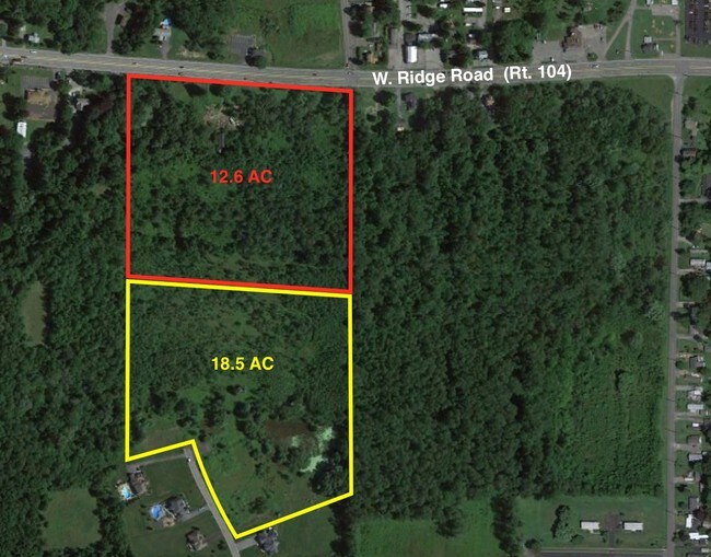
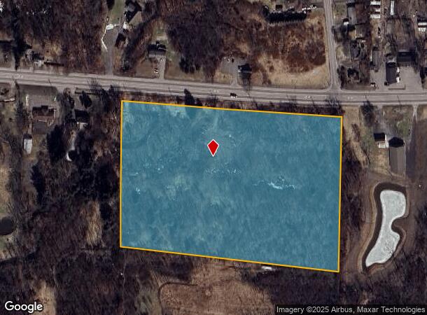
4771 W Ridge Rd
Rochester, NY
L35 T4 R1 COUNTRY CLASSIC EST. SEC4 LOT B L311 P77
264089-072-020-0003-078-100
Monroe
Commercialnec
New York
AE
78.100
36055C0159G
12.60 AC
2025
Northwest
2024
Rochester
014901
DEMOGRAPHICS near 4771 W Ridge Rd
1 Mile
3 Mile
5 Mile
2024 Total Population
1,029
23,510
82,899
2029 Population
1,022
23,146
81,672
Pop Growth 2024-2029
(0.68%)
(1.55%)
(1.48%)
Average Age
45
43
44
2024 Total Households
413
9,472
34,794
HH Growth 2024-2029
(0.97%)
(1.66%)
(1.57%)
Median Household Inc
$121,551
$78,722
$75,530
Avg Household Size
2.40
2.40
2.30
2024 Avg HH Vehicles
2.00
2.00
2.00
Median Home Value
$271,022
$188,660
$174,514
Median Year Built
1980
1982
1978
Nearby Places
- Restaurants
- Banks
- Shops
- Fitness
- Groceries
PUBLIC TRANSPORTATION
AIRPORT
Frederick Douglass/Greater Rochester International
DRIVE
WALK
Distance
Frederick Douglass/Greater Rochester International
18 min
12.3 mi
Freight Ports
Albany, NY Port
DRIVE
WALK
Distance
Albany, NY Port
282 min
238.2 mi
SALE & LEASE HISTORY
LISTING DATE
SALE/LEASE

Oct 05, 2016
For Sale
Mar 27, 2017
For Sale
Nearby Properties
Address
Land Use
TOTAL SIZE
Lot Size
Zoning
Address
Land Use
TOTAL SIZE
Lot Size
Zoning
279,852 SF
78.40 AC
R-1
Address
Land Use
TOTAL SIZE
Lot Size
Zoning
149,427 SF
10.90 AC
R-1
Address
Land Use
TOTAL SIZE
Lot Size
Zoning
565.09 AC
Address
Land Use
TOTAL SIZE
Lot Size
Zoning
180,566 SF
13.30 AC
R-1
Address
Land Use
TOTAL SIZE
Lot Size
Zoning
87,106 SF
8.66 AC
SC
Address
Land Use
TOTAL SIZE
Lot Size
Zoning
136,148 SF
12.53 AC
Address
Land Use
TOTAL SIZE
Lot Size
Zoning
60,509 SF
29.40 AC
R-1
Address
Land Use
TOTAL SIZE
Lot Size
Zoning
1.70 AC
Address
Land Use
TOTAL SIZE
Lot Size
Zoning
44,643 SF
5.80 AC
05 - COMME
Address
Land Use
TOTAL SIZE
Lot Size
Zoning
8,386 SF
15.50 AC
MFR
Address
Land Use
TOTAL SIZE
Lot Size
Zoning
65,962 SF
19.71 AC
Address
Land Use
TOTAL SIZE
Lot Size
Zoning
49,100 SF
10.83 AC
05 - COMME
Address
Land Use
TOTAL SIZE
Lot Size
Zoning
86,432 SF
34.86 AC
R-1
Address
Land Use
TOTAL SIZE
Lot Size
Zoning
36,320 SF
9.97 AC
05 - COMME
Address
Land Use
TOTAL SIZE
Lot Size
Zoning
12,100 SF
15.63 AC
05 - COMME
Address
Land Use
TOTAL SIZE
Lot Size
Zoning
32,415 SF
9.18 AC
Address
Land Use
TOTAL SIZE
Lot Size
Zoning
42,944 SF
8.04 AC
05 - COMME
Address
Land Use
TOTAL SIZE
Lot Size
Zoning
30,650 SF
8.08 AC
02 - SINGL
Address
Land Use
TOTAL SIZE
Lot Size
Zoning
41,255 SF
9.03 AC
05 - COMME
Address
Land Use
TOTAL SIZE
Lot Size
Zoning
13,764 SF
10.90 AC
MFR
Address
Land Use
TOTAL SIZE
Lot Size
Zoning
71,344 SF
29.90 AC
R-1
Address
Land Use
TOTAL SIZE
Lot Size
Zoning
119,491 SF
13.57 AC
Address
Land Use
TOTAL SIZE
Lot Size
Zoning
19,280 SF
1.15 AC
B2
Address
Land Use
TOTAL SIZE
Lot Size
Zoning
131,408 SF
10.43 AC
05 - COMME
Address
Land Use
TOTAL SIZE
Lot Size
Zoning
114,663 SF
11.81 AC
Address
Land Use
TOTAL SIZE
Lot Size
Zoning
14,671 SF
33.82 AC
GC
Address
Land Use
TOTAL SIZE
Lot Size
Zoning
86,965 SF
8.25 AC
Address
Land Use
TOTAL SIZE
Lot Size
Zoning
64,308 SF
22.10 AC
R-1
Address
Land Use
TOTAL SIZE
Lot Size
Zoning
76,560 SF
8.59 AC
05 - COMME
Address
Land Use
TOTAL SIZE
Lot Size
Zoning
5,260 SF
5.63 AC
SC
The World's #1 Commercial Real Estate Marketplace
Connect with us
© 2025 CoStar Group
The information above has been obtained from sources believed reliable. While we do not doubt its accuracy we have not verified it and make no guarantee, warranty or representation about it. It is your responsibility to independently confirm its accuracy and completeness. Any projections, opinions, assumptions, or estimates used are for example only and do not represent the current or future performance of the property. The value of this transaction to you depends on tax and other factors which should be evaluated by your tax, financial, and legal advisors. You and your advisors should conduct a careful, independent investigation of the property to determine to your satisfaction the suitability of the property for your needs.