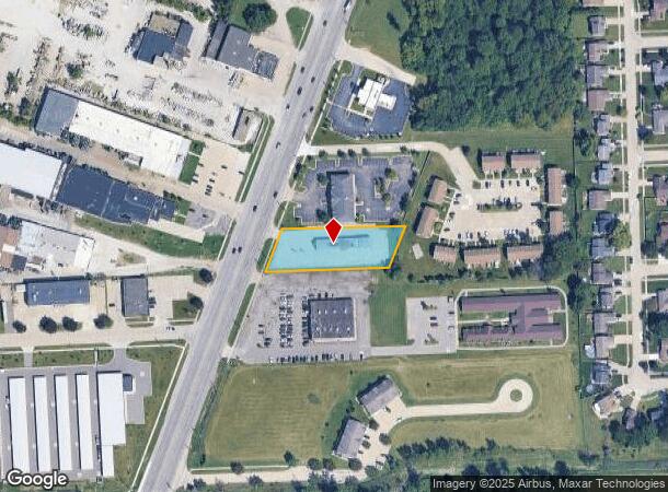
Property Record
47720 Gratiot Ave, Chesterfield, MI 48051
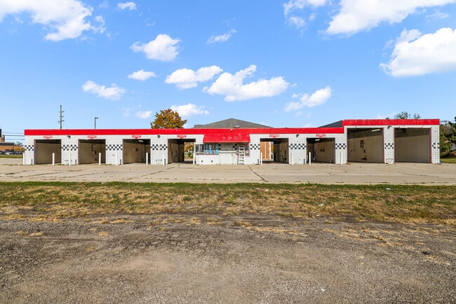
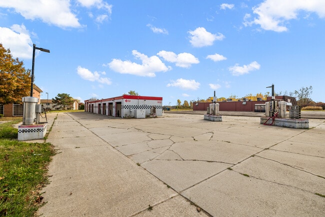
This Property Is For Sale
NEARBY LISTINGS FOR SALE OR LEASE
Property Detail
47720 Gratiot Ave
Detroit-Warren-Dearborn, MI
Gratiot
15-09-30-326-012
T3N R14E SEC 30 PT OF LOT 9 S.P. NO 19 COMM AT A PT 227.13 FT S21*26'W ALG THE ELY SIDELINE OF GRATIOT AVE (120 FT WD) FROM
Commercialnec
Macomb
X
Michigan
26099C0263G
9
2025
0.82 AC
2025
Macomb East
221100
Detroit
3,942 SF
DEMOGRAPHICS near 47720 Gratiot Ave
1 Mile
3 Mile
5 Mile
2024 Total Population
5,750
48,521
141,292
2029 Population
5,727
48,326
140,309
Pop Growth 2024-2029
(0.40%)
(0.40%)
(0.70%)
Average Age
41
40
40
2024 Total Households
2,161
18,612
54,569
HH Growth 2024-2029
(0.51%)
(0.34%)
(0.65%)
Median Household Inc
$93,925
$81,472
$84,015
Avg Household Size
2.60
2.60
2.50
2024 Avg HH Vehicles
2.00
2.00
2.00
Median Home Value
$242,750
$261,620
$274,906
Median Year Built
1992
1995
1992
Nearby Places
Map Layers
Map Styles
 Street
 Aerial
- Restaurants
- Banks
- Shops
- Fitness
- Groceries
PUBLIC TRANSPORTATION
AIRPORT
Windsor International
DRIVE
WALK
Distance
Windsor International
62 min
39.1 mi
Detroit Metro Wayne County
DRIVE
WALK
Distance
Detroit Metro Wayne County
65 min
48.6 mi
Nearby Properties
Address
Land Use
TOTAL SIZE
Lot Size
Zoning
Address
Land Use
TOTAL SIZE
Lot Size
Zoning
808,240 SF
60.31 AC
RM 3 MU
Address
Land Use
TOTAL SIZE
Lot Size
Zoning
404,160 SF
22.52 AC
I-1
Address
Land Use
TOTAL SIZE
Lot Size
Zoning
181,094 SF
14.89 AC
C3 GEN
Address
Land Use
TOTAL SIZE
Lot Size
Zoning
196,459 SF
19.18 AC
I-1
Address
Land Use
TOTAL SIZE
Lot Size
Zoning
143,731 SF
16.25 AC
C2 SHO
Address
Land Use
TOTAL SIZE
Lot Size
Zoning
229,878 SF
19.93 AC
C4 MULT
Address
Land Use
TOTAL SIZE
Lot Size
Zoning
42,385 SF
25.55 AC
B-2
Address
Land Use
TOTAL SIZE
Lot Size
Zoning
72,572 SF
10 AC
B-3
Address
Land Use
TOTAL SIZE
Lot Size
Zoning
134,327 SF
10.02 AC
I-1
Address
Land Use
TOTAL SIZE
Lot Size
Zoning
167,281 SF
16.12 AC
C3 GEN
Address
Land Use
TOTAL SIZE
Lot Size
Zoning
600 SF
18.79 AC
R2L
Address
Land Use
TOTAL SIZE
Lot Size
Zoning
124,956 SF
15.78 AC
C2 SHO
Address
Land Use
TOTAL SIZE
Lot Size
Zoning
87.32 AC
MH
Address
Land Use
TOTAL SIZE
Lot Size
Zoning
115,349 SF
14.39 AC
C3
Address
Land Use
TOTAL SIZE
Lot Size
Zoning
45,864 SF
4.60 AC
C2
Address
Land Use
TOTAL SIZE
Lot Size
Zoning
149,652 SF
8.04 AC
SP-1
Address
Land Use
TOTAL SIZE
Lot Size
Zoning
88,452 SF
8.36 AC
C3 GEN
Address
Land Use
TOTAL SIZE
Lot Size
Zoning
204,318 SF
27.75 AC
C3 GEN
Address
Land Use
TOTAL SIZE
Lot Size
Zoning
136,474 SF
12.62 AC
I-1
Address
Land Use
TOTAL SIZE
Lot Size
Zoning
98,014 SF
8.69 AC
I-1
Address
Land Use
TOTAL SIZE
Lot Size
Zoning
679,606 SF
29.98 AC
M2 GEN
Address
Land Use
TOTAL SIZE
Lot Size
Zoning
123,184 SF
10.02 AC
I-1
Address
Land Use
TOTAL SIZE
Lot Size
Zoning
218,662 SF
16.61 AC
M2 GEN
Address
Land Use
TOTAL SIZE
Lot Size
Zoning
138,834 SF
16.46 AC
I-1
Address
Land Use
TOTAL SIZE
Lot Size
Zoning
72,184 SF
69.68 AC
M2 GEN
Address
Land Use
TOTAL SIZE
Lot Size
Zoning
84,112 SF
8.01 AC
I-1
Address
Land Use
TOTAL SIZE
Lot Size
Zoning
54,865 SF
14 AC
C4
Address
Land Use
TOTAL SIZE
Lot Size
Zoning
118,368 SF
14.46 AC
RM 3 MU
Address
Land Use
TOTAL SIZE
Lot Size
Zoning
184,401 SF
19.98 AC
RM 3 MU
Address
Land Use
TOTAL SIZE
Lot Size
Zoning
134,490 SF
6.09 AC
C4 MULT
The World's #1 Commercial Real Estate Marketplace
Connect with us
© 2025 CoStar Group
The information above has been obtained from sources believed reliable. While we do not doubt its accuracy we have not verified it and make no guarantee, warranty or representation about it. It is your responsibility to independently confirm its accuracy and completeness. Any projections, opinions, assumptions, or estimates used are for example only and do not represent the current or future performance of the property. The value of this transaction to you depends on tax and other factors which should be evaluated by your tax, financial, and legal advisors. You and your advisors should conduct a careful, independent investigation of the property to determine to your satisfaction the suitability of the property for your needs.