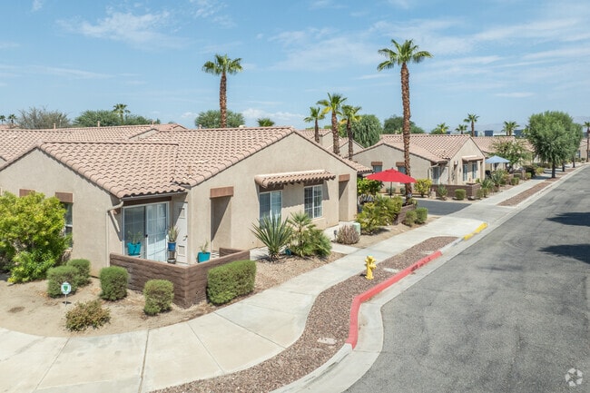
Property Record
47747 Gertrude Way, La Quinta, CA 92253


NEARBY LISTINGS FOR SALE OR LEASE
-
-
View all La Quinta listings for sale on LoopNet.com
Property Detail
47747 Gertrude Way
600-020-013
10.51 ACRES M/L IN POR SE 1/4 OF SEC 29 T5S R7E FOR TOTAL DESCRIPTION SEE ASSESSORS MAPS
Apartment
Riverside
X
California
06065C2234G
10.51 AC
2024
Outlying Palm Springs
2025
Inland Empire (California)
045129
Riverside-San Bernardino-Ontario, CA
103,618 SF
DEMOGRAPHICS near 47747 Gertrude Way
1 Mile
3 Mile
5 Mile
2024 Total Population
9,869
85,858
192,626
2029 Population
10,541
92,435
208,026
Pop Growth 2024-2029
+ 6.81%
+ 7.66%
+ 7.99%
Average Age
41
42
43
2024 Total Households
3,459
31,469
69,834
HH Growth 2024-2029
+ 6.88%
+ 7.98%
+ 8.53%
Median Household Inc
$75,688
$69,506
$71,032
Avg Household Size
2.80
2.60
2.70
2024 Avg HH Vehicles
2.00
2.00
2.00
Median Home Value
$488,553
$507,273
$477,734
Median Year Built
2000
1994
1995
Nearby Places
Map Layers
Map Styles
 Street
 Aerial
- Restaurants
- Banks
- Shops
- Fitness
- Groceries
PUBLIC TRANSPORTATION
AIRPORT
Palm Springs International
DRIVE
WALK
Distance
Palm Springs International
30 min
21.7 mi
Freight Ports
Port of San Diego
DRIVE
WALK
Distance
Port of San Diego
175 min
130.0 mi
Nearby Properties
Address
Land Use
TOTAL SIZE
Lot Size
Zoning
Address
Land Use
TOTAL SIZE
Lot Size
Zoning
260,171 SF
39.83 AC
R3
Address
Land Use
TOTAL SIZE
Lot Size
Zoning
51.81 AC
Address
Land Use
TOTAL SIZE
Lot Size
Zoning
21,992 SF
16.71 AC
Address
Land Use
TOTAL SIZE
Lot Size
Zoning
110,000 SF
39.46 AC
Address
Land Use
TOTAL SIZE
Lot Size
Zoning
162,192 SF
15.42 AC
Address
Land Use
TOTAL SIZE
Lot Size
Zoning
110,354 SF
14.15 AC
RH
Address
Land Use
TOTAL SIZE
Lot Size
Zoning
73,832 SF
7.71 AC
Address
Land Use
TOTAL SIZE
Lot Size
Zoning
233,006 SF
19.12 AC
Address
Land Use
TOTAL SIZE
Lot Size
Zoning
92,591 SF
4.56 AC
Address
Land Use
TOTAL SIZE
Lot Size
Zoning
128,503 SF
6.25 AC
R3
Address
Land Use
TOTAL SIZE
Lot Size
Zoning
229,800 SF
3.89 AC
Address
Land Use
TOTAL SIZE
Lot Size
Zoning
13.85 AC
Address
Land Use
TOTAL SIZE
Lot Size
Zoning
182,439 SF
10.76 AC
A110
Address
Land Use
TOTAL SIZE
Lot Size
Zoning
123,134 SF
6.61 AC
RM
Address
Land Use
TOTAL SIZE
Lot Size
Zoning
189,101 SF
8.98 AC
C1
Address
Land Use
TOTAL SIZE
Lot Size
Zoning
55,072 SF
6.88 AC
C2
Address
Land Use
TOTAL SIZE
Lot Size
Zoning
170,272 SF
16.28 AC
Address
Land Use
TOTAL SIZE
Lot Size
Zoning
171,910 SF
14.89 AC
C1
Address
Land Use
TOTAL SIZE
Lot Size
Zoning
42,000 SF
3.20 AC
CR
Address
Land Use
TOTAL SIZE
Lot Size
Zoning
250,835 SF
10.27 AC
VC
Address
Land Use
TOTAL SIZE
Lot Size
Zoning
144,647 SF
16.60 AC
Address
Land Use
TOTAL SIZE
Lot Size
Zoning
153,418 SF
6.81 AC
Address
Land Use
TOTAL SIZE
Lot Size
Zoning
83,753 SF
2.77 AC
RM
Address
Land Use
TOTAL SIZE
Lot Size
Zoning
55,695 SF
10.60 AC
C1
Address
Land Use
TOTAL SIZE
Lot Size
Zoning
81,004 SF
2.99 AC
Address
Land Use
TOTAL SIZE
Lot Size
Zoning
99,301 SF
Address
Land Use
TOTAL SIZE
Lot Size
Zoning
47,305 SF
7.24 AC
RC
Address
Land Use
TOTAL SIZE
Lot Size
Zoning
52,971 SF
7.29 AC
Address
Land Use
TOTAL SIZE
Lot Size
Zoning
162,335 SF
13.66 AC
Address
Land Use
TOTAL SIZE
Lot Size
Zoning
2,841 SF
7.51 AC
A1
The World's #1 Commercial Real Estate Marketplace
Connect with us
© 2025 CoStar Group
The information above has been obtained from sources believed reliable. While we do not doubt its accuracy we have not verified it and make no guarantee, warranty or representation about it. It is your responsibility to independently confirm its accuracy and completeness. Any projections, opinions, assumptions, or estimates used are for example only and do not represent the current or future performance of the property. The value of this transaction to you depends on tax and other factors which should be evaluated by your tax, financial, and legal advisors. You and your advisors should conduct a careful, independent investigation of the property to determine to your satisfaction the suitability of the property for your needs.