Property Record
478 State Highway M35, Negaunee, MI 49866


NEARBY LISTINGS FOR SALE OR LEASE
-
-
View all Negaunee listings for sale on LoopNet.com
Property Detail
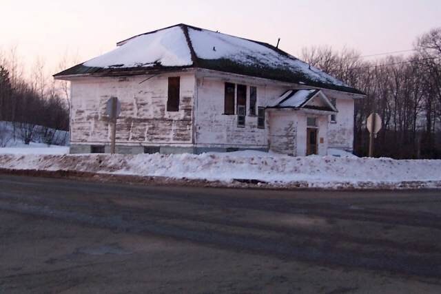
478 State Highway M35
52-10-002-014-00
SEC 2 T47N R26W S 208' OF E 208' OF SW 1/4 OF SW 1/4 EXC CO RD ROWS.
Commercialnec
Marquette
X
Michigan
26103C0657E
1 AC
2025
Upper Peninsula
2025
Other Market Areas
001300
Marquette, MI
2,788 SF
DEMOGRAPHICS near 478 State Highway M35
1 Mile
3 Mile
5 Mile
2024 Total Population
177
1,035
9,476
2029 Population
181
1,057
9,625
Pop Growth 2024-2029
+ 2.26%
+ 2.13%
+ 1.57%
Average Age
42
42
41
2024 Total Households
70
413
3,954
HH Growth 2024-2029
+ 2.86%
+ 2.42%
+ 1.69%
Median Household Inc
$93,333
$89,560
$64,954
Avg Household Size
2.60
2.50
2.30
2024 Avg HH Vehicles
2.00
2.00
2.00
Median Home Value
$269,565
$250,854
$162,047
Median Year Built
1980
1977
1958
Nearby Places
Map Layers
Map Styles
 Street
 Aerial
- Restaurants
- Banks
- Shops
- Fitness
- Groceries
PUBLIC TRANSPORTATION
AIRPORT
Marquette/Sawyer Regional
DRIVE
WALK
Distance
Marquette/Sawyer Regional
24 min
14.5 mi
Freight Ports
Port Milwaukee
DRIVE
WALK
Distance
Port Milwaukee
355 min
289.0 mi
Nearby Properties
Address
Land Use
TOTAL SIZE
Lot Size
Zoning
Address
Land Use
TOTAL SIZE
Lot Size
Zoning
144,017 SF
104 AC
PUD
Address
Land Use
TOTAL SIZE
Lot Size
Zoning
17,687 SF
13.49 AC
GB GENERAL
Address
Land Use
TOTAL SIZE
Lot Size
Zoning
35,520 SF
8.78 AC
I - IND
Address
Land Use
TOTAL SIZE
Lot Size
Zoning
17,316 SF
1.50 AC
GB GENERAL
Address
Land Use
TOTAL SIZE
Lot Size
Zoning
13,500 SF
10.13 AC
I - IND
Address
Land Use
TOTAL SIZE
Lot Size
Zoning
34,066 SF
66.90 AC
PUD
Address
Land Use
TOTAL SIZE
Lot Size
Zoning
5,860 SF
106.87 AC
R-2-SFR
Address
Land Use
TOTAL SIZE
Lot Size
Zoning
4,920 SF
3.50 AC
GB GENERAL
Address
Land Use
TOTAL SIZE
Lot Size
Zoning
12,000 SF
0.72 AC
RB RESTRIC
Address
Land Use
TOTAL SIZE
Lot Size
Zoning
1,456 SF
0.98 AC
R-3-L/R
Address
Land Use
TOTAL SIZE
Lot Size
Zoning
5,955 SF
5.10 AC
RB RESTRIC
Address
Land Use
TOTAL SIZE
Lot Size
Zoning
9,900 SF
3.76 AC
B-1-BUS
Address
Land Use
TOTAL SIZE
Lot Size
Zoning
6,708 SF
1.35 AC
B-1-BUS
Address
Land Use
TOTAL SIZE
Lot Size
Zoning
9,460 SF
1.78 AC
B-1-BUS
Address
Land Use
TOTAL SIZE
Lot Size
Zoning
1,704 SF
1.01 AC
R-2-SFR
Address
Land Use
TOTAL SIZE
Lot Size
Zoning
4,200 SF
2.83 AC
GB GENERAL
Address
Land Use
TOTAL SIZE
Lot Size
Zoning
3,360 SF
2 AC
RB RESTRIC
Address
Land Use
TOTAL SIZE
Lot Size
Zoning
1,154 SF
1.20 AC
GB GENERAL
Address
Land Use
TOTAL SIZE
Lot Size
Zoning
7,200 SF
1.29 AC
GB GENERAL
Address
Land Use
TOTAL SIZE
Lot Size
Zoning
185.16 AC
I - IND
Address
Land Use
TOTAL SIZE
Lot Size
Zoning
2,744 SF
40 AC
F - FOR
Address
Land Use
TOTAL SIZE
Lot Size
Zoning
1,620 SF
25 AC
R-2-SFR
Address
Land Use
TOTAL SIZE
Lot Size
Zoning
6,400 SF
4.06 AC
B-1-BUS
Address
Land Use
TOTAL SIZE
Lot Size
Zoning
7,374 SF
1.68 AC
GB GENERAL
Address
Land Use
TOTAL SIZE
Lot Size
Zoning
6,360 SF
1.26 AC
RB RESTRIC
Address
Land Use
TOTAL SIZE
Lot Size
Zoning
6,720 SF
1.09 AC
B-1-BUS
Address
Land Use
TOTAL SIZE
Lot Size
Zoning
1,344 SF
10.90 AC
R-2-SFR
Address
Land Use
TOTAL SIZE
Lot Size
Zoning
5,256 SF
1.37 AC
B-1-BUS
Address
Land Use
TOTAL SIZE
Lot Size
Zoning
3,200 SF
4.40 AC
GB GENERAL
Address
Land Use
TOTAL SIZE
Lot Size
Zoning
4,762 SF
1 AC
GB GENERAL
The World's #1 Commercial Real Estate Marketplace
Connect with us
© 2026 CoStar Group
The information above has been obtained from sources believed reliable. While we do not doubt its accuracy we have not verified it and make no guarantee, warranty or representation about it. It is your responsibility to independently confirm its accuracy and completeness. Any projections, opinions, assumptions, or estimates used are for example only and do not represent the current or future performance of the property. The value of this transaction to you depends on tax and other factors which should be evaluated by your tax, financial, and legal advisors. You and your advisors should conduct a careful, independent investigation of the property to determine to your satisfaction the suitability of the property for your needs.