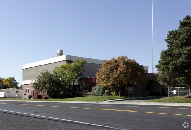
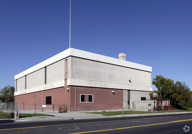
Property Record
4780 S 4015 W, Taylorsville, UT 84129
NEARBY LISTINGS FOR SALE OR LEASE
Property Detail
4780 S 4015 W
Salt Lake City, UT
Hoffman Heights
21-07-234-024-0000
BEG AT NE COR LOT 119, BLK 101, HOFFMAN HEIGHTS #15; N 89^ 5430 W 229.51 FT; N 0^0530 E 75 FT; S 89^5430 E 97.45 FT; S 54^43 E 53.2 FT; S 63^1906 E 99.06 FT TO BEG 0.27 AC
Commercialacreage
Salt Lake
X
Utah
49035C0290G
119
2024
0.18 AC
2025
West Murray
113805
Salt Lake City
DEMOGRAPHICS near 4780 S 4015 W
1 Mile
3 Mile
5 Mile
2024 Total Population
21,863
180,337
339,453
2029 Population
22,184
182,702
343,010
Pop Growth 2024-2029
+ 1.47%
+ 1.31%
+ 1.05%
Average Age
36
36
36
2024 Total Households
6,348
54,078
103,131
HH Growth 2024-2029
+ 1.35%
+ 1.31%
+ 1.02%
Median Household Inc
$68,871
$75,072
$77,415
Avg Household Size
3.30
3.20
3.20
2024 Avg HH Vehicles
2.00
2.00
2.00
Median Home Value
$318,280
$344,896
$357,382
Median Year Built
1971
1980
1985
Nearby Places
Map Layers
Map Styles
 Street
 Aerial
- Restaurants
- Banks
- Shops
- Fitness
- Groceries
PUBLIC TRANSPORTATION
AIRPORT
Salt Lake City International
DRIVE
WALK
Distance
Salt Lake City International
14 min
8.7 mi
Provo Municipal
DRIVE
WALK
Distance
Provo Municipal
56 min
42.3 mi
Nearby Properties
Address
Land Use
TOTAL SIZE
Lot Size
Zoning
Address
Land Use
TOTAL SIZE
Lot Size
Zoning
895,175 SF
28.95 AC
SSD-X
Address
Land Use
TOTAL SIZE
Lot Size
Zoning
828,269 SF
9.06 AC
RM
Address
Land Use
TOTAL SIZE
Lot Size
Zoning
187.81 AC
P-F
Address
Land Use
TOTAL SIZE
Lot Size
Zoning
329,306 SF
14.67 AC
5005
Address
Land Use
TOTAL SIZE
Lot Size
Zoning
185,436 SF
25.23 AC
RM
Address
Land Use
TOTAL SIZE
Lot Size
Zoning
382,335 SF
63.87 AC
OS
Address
Land Use
TOTAL SIZE
Lot Size
Zoning
123,864 SF
6.75 AC
C-2
Address
Land Use
TOTAL SIZE
Lot Size
Zoning
178,102 SF
15.95 AC
C-3
Address
Land Use
TOTAL SIZE
Lot Size
Zoning
187,717 SF
15.02 AC
R-M
Address
Land Use
TOTAL SIZE
Lot Size
Zoning
401,887 SF
3.51 AC
RM
Address
Land Use
TOTAL SIZE
Lot Size
Zoning
63,758 SF
13.93 AC
RM
Address
Land Use
TOTAL SIZE
Lot Size
Zoning
40,042 SF
15.43 AC
R-3-16
Address
Land Use
TOTAL SIZE
Lot Size
Zoning
289,725 SF
8.42 AC
1108
Address
Land Use
TOTAL SIZE
Lot Size
Zoning
250,027 SF
8.46 AC
PF
Address
Land Use
TOTAL SIZE
Lot Size
Zoning
89,239 SF
14.78 AC
RM
Address
Land Use
TOTAL SIZE
Lot Size
Zoning
381,105 SF
2.88 AC
CC
Address
Land Use
TOTAL SIZE
Lot Size
Zoning
57,772 SF
8.09 AC
MU
Address
Land Use
TOTAL SIZE
Lot Size
Zoning
186,337 SF
20 AC
1107
Address
Land Use
TOTAL SIZE
Lot Size
Zoning
46,874 SF
16.35 AC
RM
Address
Land Use
TOTAL SIZE
Lot Size
Zoning
603,730 SF
31.77 AC
PO
Address
Land Use
TOTAL SIZE
Lot Size
Zoning
393,809 SF
2.86 AC
CC
Address
Land Use
TOTAL SIZE
Lot Size
Zoning
314,994 SF
10 AC
R-3
Address
Land Use
TOTAL SIZE
Lot Size
Zoning
330,834 SF
7.60 AC
R-1-8
Address
Land Use
TOTAL SIZE
Lot Size
Zoning
60,960 SF
10.55 AC
RM
Address
Land Use
TOTAL SIZE
Lot Size
Zoning
297,972 SF
45.67 AC
M
Address
Land Use
TOTAL SIZE
Lot Size
Zoning
72 AC
2000
Address
Land Use
TOTAL SIZE
Lot Size
Zoning
65,853 SF
13.26 AC
R-M
Address
Land Use
TOTAL SIZE
Lot Size
Zoning
107,985 SF
9.95 AC
C-2
Address
Land Use
TOTAL SIZE
Lot Size
Zoning
212,831 SF
19 AC
1108
Address
Land Use
TOTAL SIZE
Lot Size
Zoning
72,730 SF
8.34 AC
C-3
The World's #1 Commercial Real Estate Marketplace
Connect with us
© 2025 CoStar Group
The information above has been obtained from sources believed reliable. While we do not doubt its accuracy we have not verified it and make no guarantee, warranty or representation about it. It is your responsibility to independently confirm its accuracy and completeness. Any projections, opinions, assumptions, or estimates used are for example only and do not represent the current or future performance of the property. The value of this transaction to you depends on tax and other factors which should be evaluated by your tax, financial, and legal advisors. You and your advisors should conduct a careful, independent investigation of the property to determine to your satisfaction the suitability of the property for your needs.