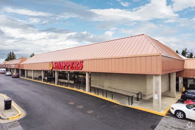
Property Record
4801 Marlboro Pike, Capitol Heights, MD 20743


Current Lease Availabilities
NEARBY LISTINGS FOR SALE OR LEASE
Property Detail
4801 Marlboro Pike
06-0600254
Coral Hills
Regionalshoppingcenterormallwithanchorstore
PARCEL J
X
Prince George's
24033C0235E
Maryland
2024
2.66 AC
2025
Pennsylvania Ave Corridor
802502
Washington, DC
91,005 SF
Washington-Arlington-Alexandria, DC-VA-MD-WV
DEMOGRAPHICS near 4801 Marlboro Pike
1 Mile
3 Mile
5 Mile
2024 Total Population
24,807
198,226
501,784
2029 Population
23,344
187,316
475,780
Pop Growth 2024-2029
(5.90%)
(5.50%)
(5.18%)
Average Age
40
39
38
2024 Total Households
9,940
80,052
212,088
HH Growth 2024-2029
(6.50%)
(6.13%)
(5.74%)
Median Household Inc
$62,534
$59,136
$72,309
Avg Household Size
2.40
2.40
2.30
2024 Avg HH Vehicles
1.00
1.00
1.00
Median Home Value
$312,825
$327,844
$382,050
Median Year Built
1959
1962
1967
Nearby Places
Map Layers
Map Styles
 Street
 Aerial
- Restaurants
- Banks
- Shops
- Fitness
- Groceries
PUBLIC TRANSPORTATION
COMMUTER RAIL
Lead (Fredericksburg Line - Virginia Railway Express, Manassas Line - Virginia Railway Express)
DRIVE
WALK
Distance
Lead (Fredericksburg Line - Virginia Railway Express, Manassas Line - Virginia Railway Express)
11 min
5.2 mi
Union Station (Brunswick Line - Maryland Area Regional Commuter Trains (The MARC), Camden Line - Maryland Area Regional Commuter Trains (The MARC), Fredericksburg Line - Maryland Area Regional Commuter Trains (The MARC), Manassas Line - Maryland Area Regional Commuter Trains (The MARC), Penn Line - Maryland Area Regional Commuter Trains (The MARC), Red Line - Maryland Area Regional Commuter Trains (The MARC))
DRIVE
WALK
Distance
Union Station (Brunswick Line - Maryland Area Regional Commuter Trains (The MARC), Camden Line - Maryland Area Regional Commuter Trains (The MARC), Fredericksburg Line - Maryland Area Regional Commuter Trains (The MARC), Manassas Line - Maryland Area Regional Commuter Trains (The MARC), Penn Line - Maryland Area Regional Commuter Trains (The MARC), Red Line - Maryland Area Regional Commuter Trains (The MARC))
12 min
5.4 mi
AIRPORT
Ronald Reagan Washington Ntl
DRIVE
WALK
Distance
Ronald Reagan Washington Ntl
19 min
9.7 mi
Baltimore/Washington International Thurgood Marshall
DRIVE
WALK
Distance
Baltimore/Washington International Thurgood Marshall
46 min
30.2 mi
Washington Dulles International
DRIVE
WALK
Distance
Washington Dulles International
56 min
34.1 mi
Freight Ports
Port of Baltimore
DRIVE
WALK
Distance
Port of Baltimore
56 min
36.8 mi
Nearby Properties
Address
Land Use
TOTAL SIZE
Lot Size
Zoning
Address
Land Use
TOTAL SIZE
Lot Size
Zoning
21.28 AC
GOV
Address
Land Use
TOTAL SIZE
Lot Size
Zoning
169.85 AC
R-2;RA-1;U
Address
Land Use
TOTAL SIZE
Lot Size
Zoning
2,131,229 SF
144.34 AC
AG
Address
Land Use
TOTAL SIZE
Lot Size
Zoning
36.52 AC
HE-2;HE-3;
Address
Land Use
TOTAL SIZE
Lot Size
Zoning
236,535 SF
12.54 AC
R-2
Address
Land Use
TOTAL SIZE
Lot Size
Zoning
241,725 SF
4.71 AC
MU-7B;PDR-
Address
Land Use
TOTAL SIZE
Lot Size
Zoning
62.03 AC
UNZONED
Address
Land Use
TOTAL SIZE
Lot Size
Zoning
229,238 SF
1.51 AC
MU-7B
Address
Land Use
TOTAL SIZE
Lot Size
Zoning
192,440 SF
7.67 AC
R-2;RA-1
Address
Land Use
TOTAL SIZE
Lot Size
Zoning
26.64 AC
RMF20
Address
Land Use
TOTAL SIZE
Lot Size
Zoning
107,130 SF
2.98 AC
R-2;RA-1
Address
Land Use
TOTAL SIZE
Lot Size
Zoning
419,689 SF
66.84 AC
PDR-1;PDR-
Address
Land Use
TOTAL SIZE
Lot Size
Zoning
308,000 SF
1.76 AC
HE-1;HE-2
Address
Land Use
TOTAL SIZE
Lot Size
Zoning
132,000 SF
RA-1
Address
Land Use
TOTAL SIZE
Lot Size
Zoning
262,236 SF
15.26 AC
MU-8B
Address
Land Use
TOTAL SIZE
Lot Size
Zoning
379,168 SF
18.94 AC
RMF20
Address
Land Use
TOTAL SIZE
Lot Size
Zoning
181,530 SF
4.72 AC
R-2
Address
Land Use
TOTAL SIZE
Lot Size
Zoning
62,797 SF
0.55 AC
R2
Address
Land Use
TOTAL SIZE
Lot Size
Zoning
92,511 SF
1.48 AC
RA-1
Address
Land Use
TOTAL SIZE
Lot Size
Zoning
25.33 AC
UNZONED
Address
Land Use
TOTAL SIZE
Lot Size
Zoning
262 SF
24.86 AC
RMF20
Address
Land Use
TOTAL SIZE
Lot Size
Zoning
441,127 SF
2.72 AC
RF-1
Address
Land Use
TOTAL SIZE
Lot Size
Zoning
99,540 SF
3.81 AC
HE-1;HE-2
Address
Land Use
TOTAL SIZE
Lot Size
Zoning
10.63 AC
RMF20
Address
Land Use
TOTAL SIZE
Lot Size
Zoning
123,950 SF
4.65 AC
R-2
Address
Land Use
TOTAL SIZE
Lot Size
Zoning
201,421 SF
5.36 AC
RF-1
Address
Land Use
TOTAL SIZE
Lot Size
Zoning
22.19 AC
UNZONED
Address
Land Use
TOTAL SIZE
Lot Size
Zoning
206,118 SF
0.82 AC
RA-1
Address
Land Use
TOTAL SIZE
Lot Size
Zoning
99,269 SF
4.73 AC
RA-1
Address
Land Use
TOTAL SIZE
Lot Size
Zoning
142,636 SF
3.69 AC
RA-1
The World's #1 Commercial Real Estate Marketplace
Connect with us
© 2025 CoStar Group
The information above has been obtained from sources believed reliable. While we do not doubt its accuracy we have not verified it and make no guarantee, warranty or representation about it. It is your responsibility to independently confirm its accuracy and completeness. Any projections, opinions, assumptions, or estimates used are for example only and do not represent the current or future performance of the property. The value of this transaction to you depends on tax and other factors which should be evaluated by your tax, financial, and legal advisors. You and your advisors should conduct a careful, independent investigation of the property to determine to your satisfaction the suitability of the property for your needs.