Property Record
4785 Allentown Rd, Morningside, MD 20746

NEARBY LISTINGS FOR SALE OR LEASE
Property Detail
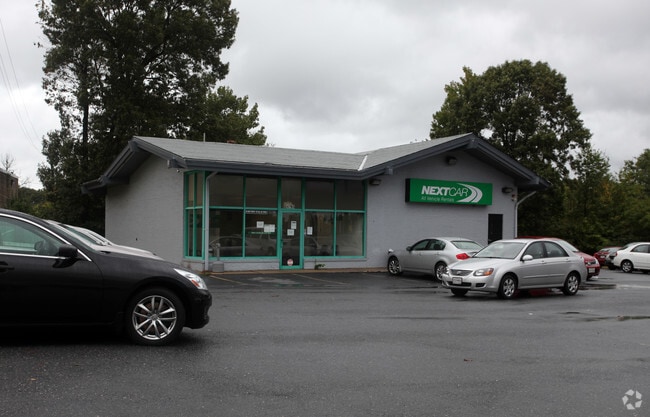
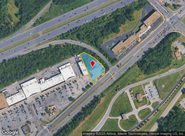
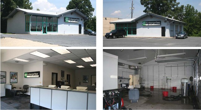
4785 Allentown Rd
Washington-Arlington-Alexandria, DC-VA-MD-WV
Andrews Manor Shopping Center
06-0480624
PARCEL W-2
Storebuilding
Prince George's
X
Maryland
24033C0235E
w-2
2024
0.88 AC
2025
Branch Avenue Corridor
801904
Washington, DC
2,050 SF
DEMOGRAPHICS near 4785 Allentown Rd
1 Mile
3 Mile
5 Mile
2024 Total Population
6,458
74,035
227,837
2029 Population
6,364
72,383
220,800
Pop Growth 2024-2029
(1.46%)
(2.23%)
(3.09%)
Average Age
38
40
41
2024 Total Households
2,349
28,888
88,900
HH Growth 2024-2029
(1.66%)
(2.36%)
(3.32%)
Median Household Inc
$91,032
$82,149
$80,234
Avg Household Size
2.60
2.50
2.50
2024 Avg HH Vehicles
2.00
2.00
2.00
Median Home Value
$327,822
$333,761
$344,284
Median Year Built
1966
1972
1972
Nearby Places
Map Layers
Map Styles
 Street
 Aerial
- Restaurants
- Banks
- Shops
- Fitness
- Groceries
PUBLIC TRANSPORTATION
COMMUTER RAIL
Union Station (Red Line - Washington Metropolitan Area Transit Authority Metrorail (Metrorail))
DRIVE
WALK
Distance
Union Station (Red Line - Washington Metropolitan Area Transit Authority Metrorail (Metrorail))
21 min
9.4 mi
AIRPORT
Ronald Reagan Washington Ntl
DRIVE
WALK
Distance
Ronald Reagan Washington Ntl
28 min
14.0 mi
Baltimore/Washington International Thurgood Marshall
DRIVE
WALK
Distance
Baltimore/Washington International Thurgood Marshall
50 min
33.6 mi
Washington Dulles International
DRIVE
WALK
Distance
Washington Dulles International
65 min
43.1 mi
Freight Ports
Port of Baltimore
DRIVE
WALK
Distance
Port of Baltimore
59 min
39.9 mi
Nearby Properties
Address
Land Use
TOTAL SIZE
Lot Size
Zoning
Address
Land Use
TOTAL SIZE
Lot Size
Zoning
963,250 SF
10.71 AC
RTOLE
Address
Land Use
TOTAL SIZE
Lot Size
Zoning
417 SF
7.66 AC
RTOLE
Address
Land Use
TOTAL SIZE
Lot Size
Zoning
26.64 AC
RMF20
Address
Land Use
TOTAL SIZE
Lot Size
Zoning
203.33 AC
IE
Address
Land Use
TOTAL SIZE
Lot Size
Zoning
386,775 SF
45.40 AC
RMF20
Address
Land Use
TOTAL SIZE
Lot Size
Zoning
6 AC
RTOLE
Address
Land Use
TOTAL SIZE
Lot Size
Zoning
111.87 AC
IE
Address
Land Use
TOTAL SIZE
Lot Size
Zoning
98.14 AC
IE
Address
Land Use
TOTAL SIZE
Lot Size
Zoning
73.26 AC
IE
Address
Land Use
TOTAL SIZE
Lot Size
Zoning
262 SF
24.86 AC
RMF20
Address
Land Use
TOTAL SIZE
Lot Size
Zoning
17.90 AC
RMF20
Address
Land Use
TOTAL SIZE
Lot Size
Zoning
223,600 SF
13.34 AC
IE
Address
Land Use
TOTAL SIZE
Lot Size
Zoning
17.08 AC
RMF20
Address
Land Use
TOTAL SIZE
Lot Size
Zoning
245,767 SF
13.88 AC
CGO
Address
Land Use
TOTAL SIZE
Lot Size
Zoning
11.82 AC
RMF20
Address
Land Use
TOTAL SIZE
Lot Size
Zoning
117.45 AC
IE
Address
Land Use
TOTAL SIZE
Lot Size
Zoning
15.65 AC
RMF20
Address
Land Use
TOTAL SIZE
Lot Size
Zoning
238,785 SF
12.79 AC
CGO
Address
Land Use
TOTAL SIZE
Lot Size
Zoning
124.59 AC
IE
Address
Land Use
TOTAL SIZE
Lot Size
Zoning
13.74 AC
RMF20
Address
Land Use
TOTAL SIZE
Lot Size
Zoning
4,059 SF
16.82 AC
IE
Address
Land Use
TOTAL SIZE
Lot Size
Zoning
133,840 SF
33.35 AC
IE
Address
Land Use
TOTAL SIZE
Lot Size
Zoning
74.38 AC
IE
Address
Land Use
TOTAL SIZE
Lot Size
Zoning
90,485 SF
18.05 AC
RSF65
Address
Land Use
TOTAL SIZE
Lot Size
Zoning
262 SF
12.74 AC
RMF20
Address
Land Use
TOTAL SIZE
Lot Size
Zoning
123,155 SF
10.75 AC
CGO
Address
Land Use
TOTAL SIZE
Lot Size
Zoning
11.47 AC
RMF20
Address
Land Use
TOTAL SIZE
Lot Size
Zoning
10.37 AC
RMF20
Address
Land Use
TOTAL SIZE
Lot Size
Zoning
111.72 AC
IE
Address
Land Use
TOTAL SIZE
Lot Size
Zoning
117.87 AC
IE
The World's #1 Commercial Real Estate Marketplace
Connect with us
© 2025 CoStar Group
The information above has been obtained from sources believed reliable. While we do not doubt its accuracy we have not verified it and make no guarantee, warranty or representation about it. It is your responsibility to independently confirm its accuracy and completeness. Any projections, opinions, assumptions, or estimates used are for example only and do not represent the current or future performance of the property. The value of this transaction to you depends on tax and other factors which should be evaluated by your tax, financial, and legal advisors. You and your advisors should conduct a careful, independent investigation of the property to determine to your satisfaction the suitability of the property for your needs.