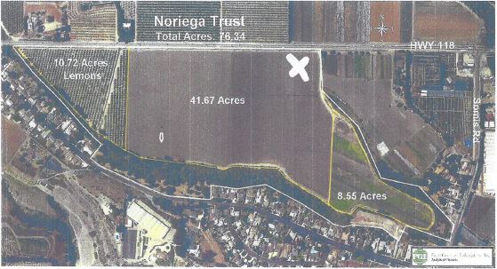
Property Record
20040311, Camarillo, CA
NEARBY LISTINGS FOR SALE OR LEASE
Property Detail
20040311
Oxnard-Thousand Oaks-Ventura, CA
LOT: 2 REF: 017PM 009
161-0-010-180
Ventura
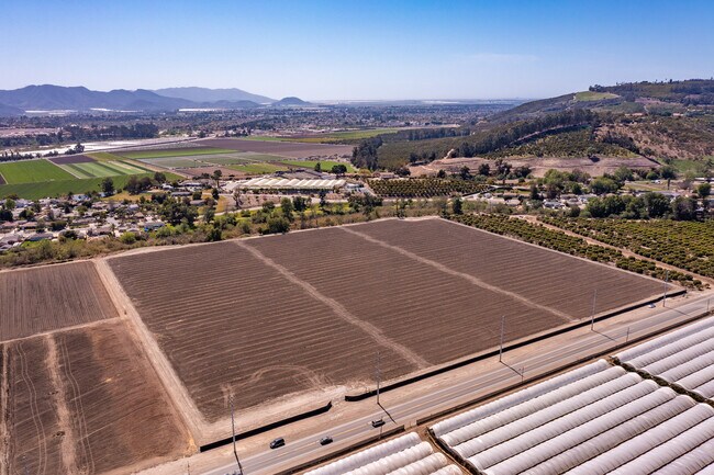
Orchard
California
A
2
06111C0813E
42.86 AC
2024
Santa Paula/Somis
2025
Los Angeles
005202
DEMOGRAPHICS near 20040311
1 Mile
3 Mile
5 Mile
2024 Total Population
1,015
31,411
73,923
2029 Population
956
30,893
72,712
Pop Growth 2024-2029
(5.81%)
(1.65%)
(1.64%)
Average Age
40
44
43
2024 Total Households
295
11,396
27,326
HH Growth 2024-2029
(6.10%)
(1.73%)
(1.73%)
Median Household Inc
$102,500
$116,816
$109,142
Avg Household Size
3.10
2.70
2.60
2024 Avg HH Vehicles
2.00
2.00
2.00
Median Home Value
$1,032,547
$776,978
$766,086
Median Year Built
1960
1979
1978
Nearby Places
Map Layers
Map Styles
 Street
 Aerial
- Restaurants
- Banks
- Shops
- Fitness
- Groceries
PUBLIC TRANSPORTATION
COMMUTER RAIL
Camarillo (Ventura County Line - Southern California Regional Rail Authority (Metrolink))
DRIVE
WALK
Distance
Camarillo (Ventura County Line - Southern California Regional Rail Authority (Metrolink))
7 min
4.1 mi
Moorpark (Ventura County Line - Southern California Regional Rail Authority (Metrolink))
DRIVE
WALK
Distance
Moorpark (Ventura County Line - Southern California Regional Rail Authority (Metrolink))
14 min
8.1 mi
Freight Ports
The Port of Hueneme
DRIVE
WALK
Distance
The Port of Hueneme
27 min
15.9 mi
SALE & LEASE HISTORY
LISTING DATE
SALE/LEASE

Mar 30, 2020
For Lease
Nearby Properties
Address
Land Use
TOTAL SIZE
Lot Size
Zoning
Address
Land Use
TOTAL SIZE
Lot Size
Zoning
9.66 AC
PO
Address
Land Use
TOTAL SIZE
Lot Size
Zoning
13.99 AC
Address
Land Use
TOTAL SIZE
Lot Size
Zoning
9.76 AC
Address
Land Use
TOTAL SIZE
Lot Size
Zoning
3.72 AC
CPD
Address
Land Use
TOTAL SIZE
Lot Size
Zoning
77,837 SF
6.46 AC
Address
Land Use
TOTAL SIZE
Lot Size
Zoning
66,716 SF
1.79 AC
Address
Land Use
TOTAL SIZE
Lot Size
Zoning
76,037 SF
6 AC
M2
Address
Land Use
TOTAL SIZE
Lot Size
Zoning
117,112 SF
9.03 AC
M-1
Address
Land Use
TOTAL SIZE
Lot Size
Zoning
4.79 AC
Address
Land Use
TOTAL SIZE
Lot Size
Zoning
86,502 SF
5.69 AC
RPD3
Address
Land Use
TOTAL SIZE
Lot Size
Zoning
6.70 AC
Address
Land Use
TOTAL SIZE
Lot Size
Zoning
45,480 SF
3.15 AC
CPD
Address
Land Use
TOTAL SIZE
Lot Size
Zoning
83,104 SF
4.85 AC
M1
Address
Land Use
TOTAL SIZE
Lot Size
Zoning
76,260 SF
4.46 AC
RPD3
Address
Land Use
TOTAL SIZE
Lot Size
Zoning
85,277 SF
4.39 AC
Address
Land Use
TOTAL SIZE
Lot Size
Zoning
12.04 AC
Address
Land Use
TOTAL SIZE
Lot Size
Zoning
9,478 SF
3.03 AC
CPD
Address
Land Use
TOTAL SIZE
Lot Size
Zoning
110,253 SF
4.50 AC
MI
Address
Land Use
TOTAL SIZE
Lot Size
Zoning
141,107 SF
6.05 AC
M1
Address
Land Use
TOTAL SIZE
Lot Size
Zoning
25,338 SF
2.65 AC
Address
Land Use
TOTAL SIZE
Lot Size
Zoning
74,503 SF
2.50 AC
M1
Address
Land Use
TOTAL SIZE
Lot Size
Zoning
78,046 SF
3.59 AC
Address
Land Use
TOTAL SIZE
Lot Size
Zoning
58,532 SF
4.29 AC
Address
Land Use
TOTAL SIZE
Lot Size
Zoning
27,376 SF
0.95 AC
Address
Land Use
TOTAL SIZE
Lot Size
Zoning
586.22 AC
AEO-S-
Address
Land Use
TOTAL SIZE
Lot Size
Zoning
0.69 AC
Address
Land Use
TOTAL SIZE
Lot Size
Zoning
40,627 SF
2.16 AC
CPD
Address
Land Use
TOTAL SIZE
Lot Size
Zoning
16,150 SF
1.53 AC
CPD
Address
Land Use
TOTAL SIZE
Lot Size
Zoning
134.97 AC
A-E
Address
Land Use
TOTAL SIZE
Lot Size
Zoning
23,648 SF
1.51 AC
The World's #1 Commercial Real Estate Marketplace
Connect with us
© 2026 CoStar Group
The information above has been obtained from sources believed reliable. While we do not doubt its accuracy we have not verified it and make no guarantee, warranty or representation about it. It is your responsibility to independently confirm its accuracy and completeness. Any projections, opinions, assumptions, or estimates used are for example only and do not represent the current or future performance of the property. The value of this transaction to you depends on tax and other factors which should be evaluated by your tax, financial, and legal advisors. You and your advisors should conduct a careful, independent investigation of the property to determine to your satisfaction the suitability of the property for your needs.