Property Record
4793 Us Highway 20 W, Wakeman, OH 44889
NEARBY LISTINGS FOR SALE OR LEASE
-
-
View all Wakeman listings for sale on LoopNet.com
Property Detail
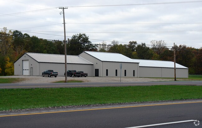
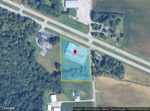
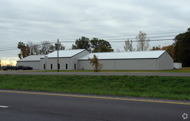
4793 Us Highway 20 W
20-0020-01-028-0000
Bellevue To Monroeville
Municipalproperty
SEC 2 PT OF GL 9 SW COR 13 AC CORR & COMB/W 051-0100 & 0200
A
Huron
39043C0195E
Ohio
2024
3.72 AC
2024
Huron County
915400
Cleveland
3,000 SF
Norwalk, OH
DEMOGRAPHICS near 4793 Us Highway 20 W
1 Mile
3 Mile
5 Mile
2024 Total Population
73
1,067
11,642
2029 Population
73
1,059
11,534
Pop Growth 2024-2029
0.00%
(0.75%)
(0.93%)
Average Age
40
40
40
2024 Total Households
28
432
4,760
HH Growth 2024-2029
0.00%
(0.93%)
(0.95%)
Median Household Inc
$69,642
$62,678
$62,494
Avg Household Size
2.50
2.50
2.40
2024 Avg HH Vehicles
3.00
2.00
2.00
Median Home Value
$150,000
$143,666
$140,866
Median Year Built
1946
1949
1956
Nearby Places
Map Layers
Map Styles
 Street
 Aerial
- Restaurants
- Banks
- Shops
- Fitness
- Groceries
Nearby Properties
Address
Land Use
TOTAL SIZE
Lot Size
Zoning
Address
Land Use
TOTAL SIZE
Lot Size
Zoning
226.95 AC
Address
Land Use
TOTAL SIZE
Lot Size
Zoning
2,008 SF
148.36 AC
Address
Land Use
TOTAL SIZE
Lot Size
Zoning
1,452 SF
95.30 AC
Address
Land Use
TOTAL SIZE
Lot Size
Zoning
2,367 SF
61.17 AC
Address
Land Use
TOTAL SIZE
Lot Size
Zoning
137.35 AC
Address
Land Use
TOTAL SIZE
Lot Size
Zoning
2,432 SF
122 AC
Address
Land Use
TOTAL SIZE
Lot Size
Zoning
130.25 AC
Address
Land Use
TOTAL SIZE
Lot Size
Zoning
117.32 AC
Address
Land Use
TOTAL SIZE
Lot Size
Zoning
1,808 SF
88 AC
Address
Land Use
TOTAL SIZE
Lot Size
Zoning
149.94 AC
Address
Land Use
TOTAL SIZE
Lot Size
Zoning
101.38 AC
Address
Land Use
TOTAL SIZE
Lot Size
Zoning
110.28 AC
Address
Land Use
TOTAL SIZE
Lot Size
Zoning
2,572 SF
74.02 AC
Address
Land Use
TOTAL SIZE
Lot Size
Zoning
3,032 SF
90.96 AC
Address
Land Use
TOTAL SIZE
Lot Size
Zoning
2,077 SF
88.27 AC
Address
Land Use
TOTAL SIZE
Lot Size
Zoning
105 AC
Address
Land Use
TOTAL SIZE
Lot Size
Zoning
97.94 AC
Address
Land Use
TOTAL SIZE
Lot Size
Zoning
1,560 SF
116.67 AC
Address
Land Use
TOTAL SIZE
Lot Size
Zoning
4,800 SF
5.54 AC
Address
Land Use
TOTAL SIZE
Lot Size
Zoning
1,598 SF
78.28 AC
Address
Land Use
TOTAL SIZE
Lot Size
Zoning
94.13 AC
Address
Land Use
TOTAL SIZE
Lot Size
Zoning
93.47 AC
Address
Land Use
TOTAL SIZE
Lot Size
Zoning
103.79 AC
Address
Land Use
TOTAL SIZE
Lot Size
Zoning
3,058 SF
122.37 AC
Address
Land Use
TOTAL SIZE
Lot Size
Zoning
1,275 SF
104 AC
Address
Land Use
TOTAL SIZE
Lot Size
Zoning
2,160 SF
58.70 AC
Address
Land Use
TOTAL SIZE
Lot Size
Zoning
92.32 AC
Address
Land Use
TOTAL SIZE
Lot Size
Zoning
1,680 SF
70.29 AC
Address
Land Use
TOTAL SIZE
Lot Size
Zoning
89.34 AC
Address
Land Use
TOTAL SIZE
Lot Size
Zoning
1,944 SF
88.50 AC
The World's #1 Commercial Real Estate Marketplace
Connect with us
© 2025 CoStar Group
The information above has been obtained from sources believed reliable. While we do not doubt its accuracy we have not verified it and make no guarantee, warranty or representation about it. It is your responsibility to independently confirm its accuracy and completeness. Any projections, opinions, assumptions, or estimates used are for example only and do not represent the current or future performance of the property. The value of this transaction to you depends on tax and other factors which should be evaluated by your tax, financial, and legal advisors. You and your advisors should conduct a careful, independent investigation of the property to determine to your satisfaction the suitability of the property for your needs.