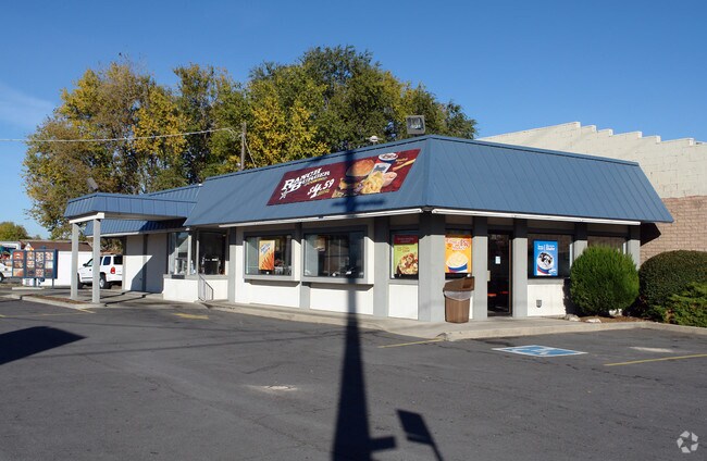
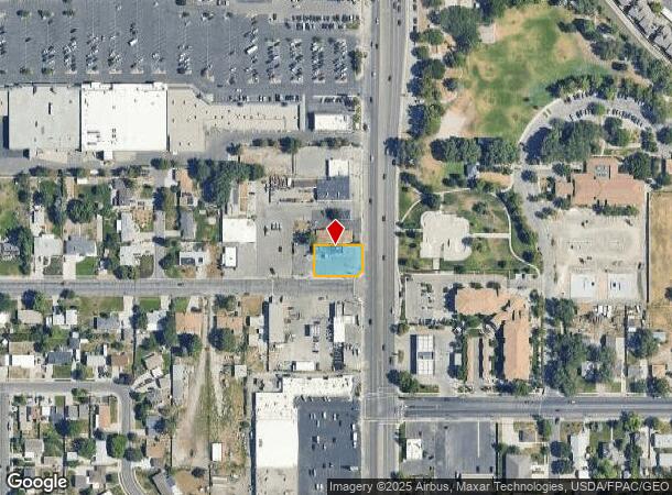
Property Record
4796 S Redwood Rd, Salt Lake City, UT 84123

NEARBY LISTINGS FOR SALE OR LEASE
Property Detail
4796 S Redwood Rd
21-10-127-022-0000
COM S 0^0255 E 840.66 FT & S 89^5705 W 53 FT FR N 1/4 COR SEC 10, T 2S, R 1W, S L M; S 0^0255 E 68.52 FT; S 44^ 5705 W 21.21 FT; W 115 FT; N 83.52 FT; E 130 FT TO BEG. 0.25 AC 4051-0470 5649-0596 5720-1952 6043-0059
Restaurantdrivein
Salt Lake
X
Utah
49035C0290G
0.25 AC
2024
Central Valley West
2025
Salt Lake City
113513
Salt Lake City, UT
1,734 SF
DEMOGRAPHICS near 4796 S Redwood Rd
1 Mile
3 Mile
5 Mile
2024 Total Population
17,070
157,379
396,010
2029 Population
17,432
159,876
400,574
Pop Growth 2024-2029
+ 2.12%
+ 1.59%
+ 1.15%
Average Age
39
37
37
2024 Total Households
5,886
53,530
135,801
HH Growth 2024-2029
+ 2.07%
+ 1.59%
+ 1.13%
Median Household Inc
$67,645
$69,584
$69,455
Avg Household Size
2.80
2.80
2.80
2024 Avg HH Vehicles
2.00
2.00
2.00
Median Home Value
$384,832
$365,592
$361,797
Median Year Built
1981
1983
1981
Nearby Places
Map Layers
Map Styles
 Street
 Aerial
- Restaurants
- Banks
- Shops
- Fitness
- Groceries
PUBLIC TRANSPORTATION
COMMUTER RAIL
DRIVE
WALK
Distance
16 min
9.7 mi
AIRPORT
Salt Lake City International
DRIVE
WALK
Distance
Salt Lake City International
17 min
10.7 mi
Provo Municipal
DRIVE
WALK
Distance
Provo Municipal
49 min
41.1 mi
Nearby Properties
Address
Land Use
TOTAL SIZE
Lot Size
Zoning
Address
Land Use
TOTAL SIZE
Lot Size
Zoning
2,024,859 SF
63 AC
C D C
Address
Land Use
TOTAL SIZE
Lot Size
Zoning
488,509 SF
36.03 AC
FLEX
Address
Land Use
TOTAL SIZE
Lot Size
Zoning
895,175 SF
28.95 AC
SSD-X
Address
Land Use
TOTAL SIZE
Lot Size
Zoning
35,897 SF
28.61 AC
RM-12
Address
Land Use
TOTAL SIZE
Lot Size
Zoning
828,269 SF
9.06 AC
RM
Address
Land Use
TOTAL SIZE
Lot Size
Zoning
521,964 SF
3.23 AC
T-O-D
Address
Land Use
TOTAL SIZE
Lot Size
Zoning
673,062 SF
15.84 AC
RM
Address
Land Use
TOTAL SIZE
Lot Size
Zoning
185,436 SF
25.23 AC
RM
Address
Land Use
TOTAL SIZE
Lot Size
Zoning
382,335 SF
63.87 AC
OS
Address
Land Use
TOTAL SIZE
Lot Size
Zoning
179,702 SF
16.99 AC
1108
Address
Land Use
TOTAL SIZE
Lot Size
Zoning
195,790 SF
14.32 AC
RM
Address
Land Use
TOTAL SIZE
Lot Size
Zoning
123,864 SF
6.75 AC
C-2
Address
Land Use
TOTAL SIZE
Lot Size
Zoning
178,102 SF
15.95 AC
C-3
Address
Land Use
TOTAL SIZE
Lot Size
Zoning
76,096 SF
17.30 AC
RM
Address
Land Use
TOTAL SIZE
Lot Size
Zoning
321,397 SF
11.16 AC
BJ
Address
Land Use
TOTAL SIZE
Lot Size
Zoning
84,870 SF
9.76 AC
MPMU
Address
Land Use
TOTAL SIZE
Lot Size
Zoning
217,700 SF
52.59 AC
FLEX
Address
Land Use
TOTAL SIZE
Lot Size
Zoning
45,924 SF
18.15 AC
R-3-20
Address
Land Use
TOTAL SIZE
Lot Size
Zoning
56,867 SF
5.33 AC
MIXED
Address
Land Use
TOTAL SIZE
Lot Size
Zoning
441,275 SF
2.62 AC
M-U
Address
Land Use
TOTAL SIZE
Lot Size
Zoning
401,887 SF
3.51 AC
RM
Address
Land Use
TOTAL SIZE
Lot Size
Zoning
63,758 SF
13.93 AC
RM
Address
Land Use
TOTAL SIZE
Lot Size
Zoning
138,180 SF
2.06 AC
RM-12
Address
Land Use
TOTAL SIZE
Lot Size
Zoning
80,985 SF
19.18 AC
RM
Address
Land Use
TOTAL SIZE
Lot Size
Zoning
29.13 AC
C-2
Address
Land Use
TOTAL SIZE
Lot Size
Zoning
289,725 SF
8.42 AC
1108
Address
Land Use
TOTAL SIZE
Lot Size
Zoning
89,239 SF
14.78 AC
RM
Address
Land Use
TOTAL SIZE
Lot Size
Zoning
137,697 SF
5.92 AC
C-2/ZC
Address
Land Use
TOTAL SIZE
Lot Size
Zoning
126,900 SF
0.38 AC
1108
Address
Land Use
TOTAL SIZE
Lot Size
Zoning
381,105 SF
2.88 AC
CC
The World's #1 Commercial Real Estate Marketplace
Connect with us
© 2025 CoStar Group
The information above has been obtained from sources believed reliable. While we do not doubt its accuracy we have not verified it and make no guarantee, warranty or representation about it. It is your responsibility to independently confirm its accuracy and completeness. Any projections, opinions, assumptions, or estimates used are for example only and do not represent the current or future performance of the property. The value of this transaction to you depends on tax and other factors which should be evaluated by your tax, financial, and legal advisors. You and your advisors should conduct a careful, independent investigation of the property to determine to your satisfaction the suitability of the property for your needs.