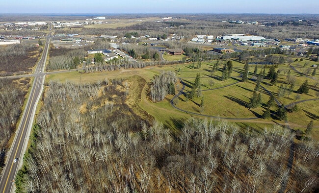
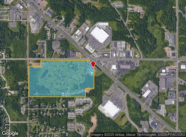
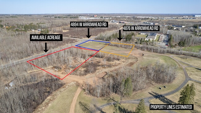
Property Record
4798 Miller Trunk Hwy, Hermantown, MN 55811
NEARBY LISTINGS FOR SALE OR LEASE
Property Detail
4798 Miller Trunk Hwy
395003000010
Arrowhead Memorial Park
Cemetery
NW1/4 OF NW1/4 AND NE1/4 OF NW1/4, EXCEPTTHE FOLLOWING DESCRIBED PROPERTY: 1. THATPART OF SAID NE1/4 OF NW1/4, LYING NORTH
X
St Louis
27137C3754E
Minnesota
2025
63.27 AC
2024
South St Louis County
010301
Duluth
7,668 SF
Duluth, MN-WI
DEMOGRAPHICS near 4798 Miller Trunk Hwy
1 Mile
3 Mile
5 Mile
2024 Total Population
2,583
11,530
39,005
2029 Population
2,606
11,437
38,463
Pop Growth 2024-2029
+ 0.89%
(0.81%)
(1.39%)
Average Age
41
43
39
2024 Total Households
968
4,568
15,654
HH Growth 2024-2029
+ 0.93%
(0.99%)
(1.68%)
Median Household Inc
$75,296
$75,491
$66,399
Avg Household Size
2.30
2.30
2.20
2024 Avg HH Vehicles
2.00
2.00
2.00
Median Home Value
$365,789
$279,006
$245,738
Median Year Built
1996
1989
1969
Nearby Places
- Restaurants
- Banks
- Shops
- Fitness
- Groceries
PUBLIC TRANSPORTATION
AIRPORT
Duluth International
DRIVE
WALK
Distance
Duluth International
11 min
3.8 mi
Freight Ports
Port Milwaukee
DRIVE
WALK
Distance
Port Milwaukee
458 min
403.0 mi
Nearby Properties
Address
Land Use
TOTAL SIZE
Lot Size
Zoning
Address
Land Use
TOTAL SIZE
Lot Size
Zoning
322,819 SF
139.41 AC
Address
Land Use
TOTAL SIZE
Lot Size
Zoning
524,275 SF
38.23 AC
Address
Land Use
TOTAL SIZE
Lot Size
Zoning
222,050 SF
5 AC
Address
Land Use
TOTAL SIZE
Lot Size
Zoning
32,824 SF
117.72 AC
Address
Land Use
TOTAL SIZE
Lot Size
Zoning
20,388 SF
20 AC
Address
Land Use
TOTAL SIZE
Lot Size
Zoning
100,246 SF
12.24 AC
Address
Land Use
TOTAL SIZE
Lot Size
Zoning
118,418 SF
13.62 AC
Address
Land Use
TOTAL SIZE
Lot Size
Zoning
7,300 SF
19.85 AC
Address
Land Use
TOTAL SIZE
Lot Size
Zoning
113,448 SF
10 AC
Address
Land Use
TOTAL SIZE
Lot Size
Zoning
62,634 SF
4.32 AC
Address
Land Use
TOTAL SIZE
Lot Size
Zoning
72,980 SF
2.85 AC
R1B
Address
Land Use
TOTAL SIZE
Lot Size
Zoning
109,021 SF
10.01 AC
Address
Land Use
TOTAL SIZE
Lot Size
Zoning
98,994 SF
185.96 AC
Address
Land Use
TOTAL SIZE
Lot Size
Zoning
158,240 SF
0.13 AC
Address
Land Use
TOTAL SIZE
Lot Size
Zoning
183,097 SF
27.58 AC
Address
Land Use
TOTAL SIZE
Lot Size
Zoning
174,964 SF
41.97 AC
Address
Land Use
TOTAL SIZE
Lot Size
Zoning
81,316 SF
1.89 AC
Address
Land Use
TOTAL SIZE
Lot Size
Zoning
176,840 SF
27.50 AC
Address
Land Use
TOTAL SIZE
Lot Size
Zoning
161,568 SF
20.87 AC
Address
Land Use
TOTAL SIZE
Lot Size
Zoning
153,866 SF
13.83 AC
Address
Land Use
TOTAL SIZE
Lot Size
Zoning
57,230 SF
4.67 AC
Address
Land Use
TOTAL SIZE
Lot Size
Zoning
172,700 SF
33.34 AC
Address
Land Use
TOTAL SIZE
Lot Size
Zoning
164,720 SF
19.81 AC
Address
Land Use
TOTAL SIZE
Lot Size
Zoning
123,720 SF
2.65 AC
Address
Land Use
TOTAL SIZE
Lot Size
Zoning
108,788 SF
2.86 AC
Address
Land Use
TOTAL SIZE
Lot Size
Zoning
21,204 SF
26.34 AC
Address
Land Use
TOTAL SIZE
Lot Size
Zoning
158,388 SF
6.21 AC
Address
Land Use
TOTAL SIZE
Lot Size
Zoning
38,952 SF
20.99 AC
Address
Land Use
TOTAL SIZE
Lot Size
Zoning
112,838 SF
40 AC
Address
Land Use
TOTAL SIZE
Lot Size
Zoning
90,980 SF
13.11 AC
R3
The World's #1 Commercial Real Estate Marketplace
Connect with us
© 2025 CoStar Group
The information above has been obtained from sources believed reliable. While we do not doubt its accuracy we have not verified it and make no guarantee, warranty or representation about it. It is your responsibility to independently confirm its accuracy and completeness. Any projections, opinions, assumptions, or estimates used are for example only and do not represent the current or future performance of the property. The value of this transaction to you depends on tax and other factors which should be evaluated by your tax, financial, and legal advisors. You and your advisors should conduct a careful, independent investigation of the property to determine to your satisfaction the suitability of the property for your needs.