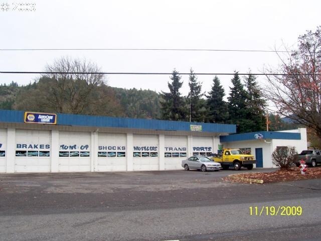
Property Record
47983 Highway 58, Oakridge, OR 97463


NEARBY LISTINGS FOR SALE OR LEASE
-
-
View all Oakridge listings for sale on LoopNet.com
Property Detail
47983 Highway 58
Eugene, OR
Forest Addition To Oakridge
1109170
TL 02002
Commercialbuilding
Lane
X
Oregon
41039C2477F
2002
2025
0.56 AC
2025
Lane County
001500
Portland
DEMOGRAPHICS near 47983 Highway 58
1 Mile
3 Mile
5 Mile
2024 Total Population
3,288
4,545
5,103
2029 Population
3,358
4,645
5,215
Pop Growth 2024-2029
+ 2.13%
+ 2.20%
+ 2.19%
Average Age
46
46
46
2024 Total Households
1,518
2,047
2,272
HH Growth 2024-2029
+ 2.11%
+ 2.15%
+ 2.16%
Median Household Inc
$34,418
$34,999
$35,205
Avg Household Size
2.20
2.20
2.20
2024 Avg HH Vehicles
2.00
2.00
2.00
Median Home Value
$141,607
$166,812
$182,212
Median Year Built
1967
1966
1966
Nearby Places
Map Layers
Map Styles
 Street
 Aerial
- Restaurants
- Banks
- Shops
- Fitness
- Groceries
SALE & LEASE HISTORY
LISTING DATE
SALE/LEASE

Mar 27, 2017
For Sale
Nearby Properties
Address
Land Use
TOTAL SIZE
Lot Size
Zoning
Address
Land Use
TOTAL SIZE
Lot Size
Zoning
5.58 AC
R1
Address
Land Use
TOTAL SIZE
Lot Size
Zoning
5,615.58 AC
F1
Address
Land Use
TOTAL SIZE
Lot Size
Zoning
248.60 AC
C3
Address
Land Use
TOTAL SIZE
Lot Size
Zoning
2.85 AC
F2
Address
Land Use
TOTAL SIZE
Lot Size
Zoning
1.24 AC
C3
Address
Land Use
TOTAL SIZE
Lot Size
Zoning
2.09 AC
C3
Address
Land Use
TOTAL SIZE
Lot Size
Zoning
0.95 AC
C3
Address
Land Use
TOTAL SIZE
Lot Size
Zoning
0.61 AC
C3
Address
Land Use
TOTAL SIZE
Lot Size
Zoning
0.80 AC
C3
Address
Land Use
TOTAL SIZE
Lot Size
Zoning
2.12 AC
PRO-S
Address
Land Use
TOTAL SIZE
Lot Size
Zoning
0.95 AC
C3
Address
Land Use
TOTAL SIZE
Lot Size
Zoning
5.11 AC
R1
Address
Land Use
TOTAL SIZE
Lot Size
Zoning
39.24 AC
F2
Address
Land Use
TOTAL SIZE
Lot Size
Zoning
0.73 AC
R1
Address
Land Use
TOTAL SIZE
Lot Size
Zoning
4.89 AC
R1
Address
Land Use
TOTAL SIZE
Lot Size
Zoning
0.73 AC
C3
Address
Land Use
TOTAL SIZE
Lot Size
Zoning
0.64 AC
C2
Address
Land Use
TOTAL SIZE
Lot Size
Zoning
1.19 AC
C3
Address
Land Use
TOTAL SIZE
Lot Size
Zoning
91.20 AC
PR
Address
Land Use
TOTAL SIZE
Lot Size
Zoning
0.54 AC
C3
Address
Land Use
TOTAL SIZE
Lot Size
Zoning
6.12 AC
I2
Address
Land Use
TOTAL SIZE
Lot Size
Zoning
956.81 AC
F1
Address
Land Use
TOTAL SIZE
Lot Size
Zoning
4.48 AC
I1
Address
Land Use
TOTAL SIZE
Lot Size
Zoning
1.27 AC
R1
Address
Land Use
TOTAL SIZE
Lot Size
Zoning
3.07 AC
C3
Address
Land Use
TOTAL SIZE
Lot Size
Zoning
0.36 AC
F2
Address
Land Use
TOTAL SIZE
Lot Size
Zoning
0.79 AC
C3
Address
Land Use
TOTAL SIZE
Lot Size
Zoning
810 SF
1 AC
C3
Address
Land Use
TOTAL SIZE
Lot Size
Zoning
0.91 AC
C3
Address
Land Use
TOTAL SIZE
Lot Size
Zoning
858 SF
4.15 AC
I1
The World's #1 Commercial Real Estate Marketplace
Connect with us
© 2025 CoStar Group
The information above has been obtained from sources believed reliable. While we do not doubt its accuracy we have not verified it and make no guarantee, warranty or representation about it. It is your responsibility to independently confirm its accuracy and completeness. Any projections, opinions, assumptions, or estimates used are for example only and do not represent the current or future performance of the property. The value of this transaction to you depends on tax and other factors which should be evaluated by your tax, financial, and legal advisors. You and your advisors should conduct a careful, independent investigation of the property to determine to your satisfaction the suitability of the property for your needs.