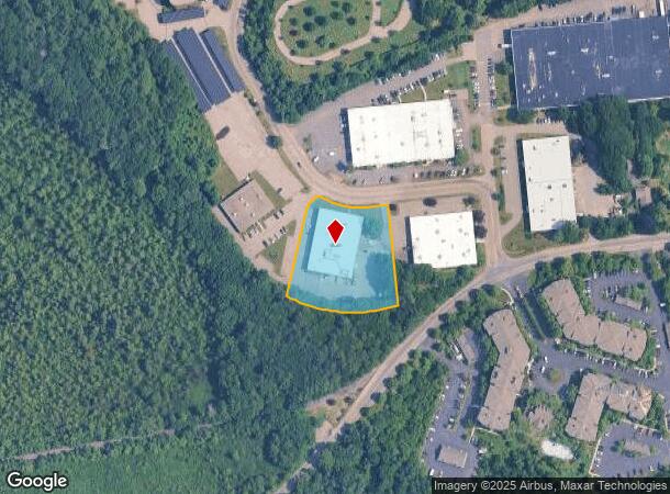
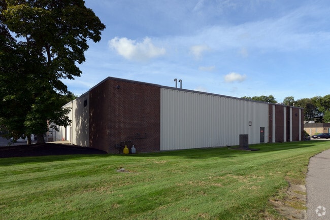
Property Record
48 Brooks Dr, Braintree, MA 02184

NEARBY LISTINGS FOR SALE OR LEASE
Property Detail
48 Brooks Dr
BRAI-002053D-000000-000006B
Norfolk
Warehouse
Massachusetts
AE
6b
25021C0208F
1.67 AC
2025
Quincy/Braintree
2025
Boston
419100
Boston-Cambridge-Newton, MA-NH
20,280 SF
DEMOGRAPHICS near 48 Brooks Dr
1 Mile
3 Mile
5 Mile
2024 Total Population
2,181
74,243
243,967
2029 Population
2,167
73,747
241,043
Pop Growth 2024-2029
(0.64%)
(0.67%)
(1.20%)
Average Age
40
41
41
2024 Total Households
757
28,952
96,329
HH Growth 2024-2029
(0.66%)
(0.60%)
(1.24%)
Median Household Inc
$98,091
$97,982
$95,959
Avg Household Size
2.70
2.50
2.40
2024 Avg HH Vehicles
2.00
2.00
2.00
Median Home Value
$484,357
$572,471
$594,156
Median Year Built
1958
1962
1958
Nearby Places
Map Layers
Map Styles
 Street
 Aerial
- Restaurants
- Banks
- Shops
- Fitness
- Groceries
PUBLIC TRANSPORTATION
COMMUTER RAIL
Braintree (Kingston/Plymouth Line - Massachusetts Bay Transportation Authority Commuter Rail (Purple Line), Middleborough/Lakeville Line - Massachusetts Bay Transportation Authority Commuter Rail (Purple Line))
DRIVE
WALK
Distance
Braintree (Kingston/Plymouth Line - Massachusetts Bay Transportation Authority Commuter Rail (Purple Line), Middleborough/Lakeville Line - Massachusetts Bay Transportation Authority Commuter Rail (Purple Line))
6 min
2.5 mi
DRIVE
WALK
Distance
9 min
4.5 mi
AIRPORT
General Edward Lawrence Logan International
DRIVE
WALK
Distance
General Edward Lawrence Logan International
25 min
14.7 mi
Rhode Island Tf Green International
DRIVE
WALK
Distance
Rhode Island Tf Green International
69 min
47.7 mi
SALE & LEASE HISTORY
LISTING DATE
SALE/LEASE

Aug 16, 2021
For Lease
Nearby Properties
Address
Land Use
TOTAL SIZE
Lot Size
Zoning
Address
Land Use
TOTAL SIZE
Lot Size
Zoning
17.33 AC
Address
Land Use
TOTAL SIZE
Lot Size
Zoning
152,495 SF
6.51 AC
Address
Land Use
TOTAL SIZE
Lot Size
Zoning
20,596 SF
16.20 AC
PUD
Address
Land Use
TOTAL SIZE
Lot Size
Zoning
14.81 AC
Address
Land Use
TOTAL SIZE
Lot Size
Zoning
0.25 AC
RH
Address
Land Use
TOTAL SIZE
Lot Size
Zoning
15.81 AC
Address
Land Use
TOTAL SIZE
Lot Size
Zoning
202,858 SF
2.30 AC
Address
Land Use
TOTAL SIZE
Lot Size
Zoning
5.06 AC
BUSC
Address
Land Use
TOTAL SIZE
Lot Size
Zoning
38.48 AC
B
Address
Land Use
TOTAL SIZE
Lot Size
Zoning
237,086 SF
15 AC
INDB
Address
Land Use
TOTAL SIZE
Lot Size
Zoning
10.38 AC
Address
Land Use
TOTAL SIZE
Lot Size
Zoning
5.38 AC
Address
Land Use
TOTAL SIZE
Lot Size
Zoning
16.08 AC
OSC
Address
Land Use
TOTAL SIZE
Lot Size
Zoning
238,217 SF
10.76 AC
INDB
Address
Land Use
TOTAL SIZE
Lot Size
Zoning
0.25 AC
I
Address
Land Use
TOTAL SIZE
Lot Size
Zoning
132,143 SF
23.70 AC
RH
Address
Land Use
TOTAL SIZE
Lot Size
Zoning
395,130 SF
6.50 AC
IND
Address
Land Use
TOTAL SIZE
Lot Size
Zoning
272,440 SF
13.16 AC
INDB
Address
Land Use
TOTAL SIZE
Lot Size
Zoning
162,790 SF
2 AC
PUD
Address
Land Use
TOTAL SIZE
Lot Size
Zoning
18.76 AC
GBD
Address
Land Use
TOTAL SIZE
Lot Size
Zoning
114,248 SF
2.63 AC
RESC
Address
Land Use
TOTAL SIZE
Lot Size
Zoning
167,076 SF
16 AC
A
Address
Land Use
TOTAL SIZE
Lot Size
Zoning
38.67 AC
PUD
Address
Land Use
TOTAL SIZE
Lot Size
Zoning
80,226 SF
6.60 AC
RES
Address
Land Use
TOTAL SIZE
Lot Size
Zoning
122,808 SF
3.41 AC
Address
Land Use
TOTAL SIZE
Lot Size
Zoning
122,160 SF
6.61 AC
PUD
Address
Land Use
TOTAL SIZE
Lot Size
Zoning
114,256 SF
4.61 AC
Address
Land Use
TOTAL SIZE
Lot Size
Zoning
494,520 SF
20.80 AC
IND
Address
Land Use
TOTAL SIZE
Lot Size
Zoning
138,400 SF
55.71 AC
RM
Address
Land Use
TOTAL SIZE
Lot Size
Zoning
146,402 SF
10 AC
RES
The World's #1 Commercial Real Estate Marketplace
Connect with us
© 2025 CoStar Group
The information above has been obtained from sources believed reliable. While we do not doubt its accuracy we have not verified it and make no guarantee, warranty or representation about it. It is your responsibility to independently confirm its accuracy and completeness. Any projections, opinions, assumptions, or estimates used are for example only and do not represent the current or future performance of the property. The value of this transaction to you depends on tax and other factors which should be evaluated by your tax, financial, and legal advisors. You and your advisors should conduct a careful, independent investigation of the property to determine to your satisfaction the suitability of the property for your needs.