Property Record
48 Danforth St, Taunton, MA 02780
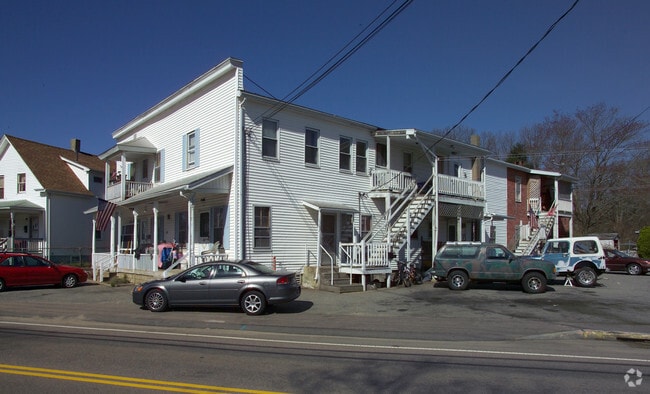

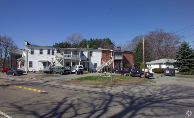
Property Detail
48 Danforth St
TAUN-000054-000066
Bristol
Apartment
Massachusetts
URBRES
66
B and X Area of moderate flood hazard, usually the area between the limits of the 100-year and 500-year floods.
0.40 AC
2025
Taunton
2025
Boston
613100
Providence-Warwick, RI-MA
NEARBY LISTINGS FOR SALE OR LEASE
-
-
View all Taunton listings for sale on LoopNet.com
DEMOGRAPHICS near 48 Danforth St
1 mile
3 mile
5 mile
2024 Total Population
12,704
48,768
79,839
2029 Population
12,826
49,363
81,115
Pop Growth 2024-2029
+ 0.96%
+ 1.22%
+ 1.60%
Average Age
41
41
42
2024 Total Households
5,364
19,864
31,328
HH Growth 2024-2029
+ 1.04%
+ 1.29%
+ 1.65%
Median Household Inc
$60,993
$69,518
$83,729
Avg Household Size
2.20
2.40
2.50
2024 Avg HH Vehicles
2.00
2.00
2.00
Median Home Value
$403,775
$418,581
$455,110
Median Year Built
1948
1961
1972
Nearby Places
Map Layers
Map Styles
 Street
 Aerial
Transit
 Traffic
 Biking
Places
Listings with unknown addresses are not visible on the map
- Restaurants
- Banks
- Shops
- Fitness
- Groceries
Nearby Properties
Address
Land Use
TOTAL SIZE
Lot Size
Zoning
Address
Land Use
TOTAL SIZE
Lot Size
Zoning
68,024 SF
66.24 AC
RURRES
Address
Land Use
TOTAL SIZE
Lot Size
Zoning
279,756 SF
11.62 AC
OFFDIS
Address
Land Use
TOTAL SIZE
Lot Size
Zoning
130,851 SF
24.43 AC
URBRES
Address
Land Use
TOTAL SIZE
Lot Size
Zoning
133,652 SF
2 AC
Address
Land Use
TOTAL SIZE
Lot Size
Zoning
147,285 SF
0.79 AC
CENBIZ
Address
Land Use
TOTAL SIZE
Lot Size
Zoning
157.20 AC
OPSPAC
Address
Land Use
TOTAL SIZE
Lot Size
Zoning
486,363 SF
41.18 AC
INDUST
Address
Land Use
TOTAL SIZE
Lot Size
Zoning
604,133 SF
42.73 AC
Address
Land Use
TOTAL SIZE
Lot Size
Zoning
315,896 SF
24.53 AC
INDUST
Address
Land Use
TOTAL SIZE
Lot Size
Zoning
335,092 SF
27.12 AC
INDUST
Address
Land Use
TOTAL SIZE
Lot Size
Zoning
681,295 SF
65.93 AC
Address
Land Use
TOTAL SIZE
Lot Size
Zoning
37.62 AC
URBRES
Address
Land Use
TOTAL SIZE
Lot Size
Zoning
160,798 SF
14.31 AC
INDUST
Address
Land Use
TOTAL SIZE
Lot Size
Zoning
39,910 SF
1.05 AC
CENBIZ
Address
Land Use
TOTAL SIZE
Lot Size
Zoning
196,420 SF
21.78 AC
INDUST
Address
Land Use
TOTAL SIZE
Lot Size
Zoning
5.20 AC
URBRES
Address
Land Use
TOTAL SIZE
Lot Size
Zoning
200,000 SF
14.56 AC
INDUST
Address
Land Use
TOTAL SIZE
Lot Size
Zoning
239,923 SF
14.24 AC
INDUST
Address
Land Use
TOTAL SIZE
Lot Size
Zoning
217,814 SF
11.30 AC
INDUST
Address
Land Use
TOTAL SIZE
Lot Size
Zoning
127,092 SF
9.37 AC
INDUST
Address
Land Use
TOTAL SIZE
Lot Size
Zoning
6.53 AC
URBRES
Address
Land Use
TOTAL SIZE
Lot Size
Zoning
45,786 SF
16 AC
URBRES
Address
Land Use
TOTAL SIZE
Lot Size
Zoning
198,720 SF
15.10 AC
INDUST
Address
Land Use
TOTAL SIZE
Lot Size
Zoning
36,336 SF
6.35 AC
RURRES
Address
Land Use
TOTAL SIZE
Lot Size
Zoning
114,057 SF
6.43 AC
INDUST
Address
Land Use
TOTAL SIZE
Lot Size
Zoning
8,000 SF
22.31 AC
Address
Land Use
TOTAL SIZE
Lot Size
Zoning
191,828 SF
17.09 AC
INDUST
Address
Land Use
TOTAL SIZE
Lot Size
Zoning
163,752 SF
28.17 AC
INDUST
Address
Land Use
TOTAL SIZE
Lot Size
Zoning
44,581 SF
14.60 AC
RURRES
Address
Land Use
TOTAL SIZE
Lot Size
Zoning
61,128 SF
0.98 AC
The World's #1 Commercial Real Estate Marketplace
Connect with us
© 2026 CoStar Group
The information above has been obtained from sources believed reliable. While we do not doubt its accuracy we have not verified it and make no guarantee, warranty or representation about it. It is your responsibility to independently confirm its accuracy and completeness. Any projections, opinions, assumptions, or estimates used are for example only and do not represent the current or future performance of the property. The value of this transaction to you depends on tax and other factors which should be evaluated by your tax, financial, and legal advisors. You and your advisors should conduct a careful, independent investigation of the property to determine to your satisfaction the suitability of the property for your needs.