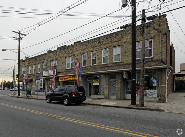
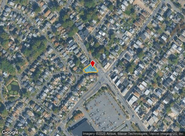
Property Record
48 Franklin St, Bloomfield, NJ 07003


NEARBY LISTINGS FOR SALE OR LEASE
Property Detail
48 Franklin St
Newark, NJ
113 X 103
02-00371-0000-00028
Essex
Storemultistory
New Jersey
X
28
34013C0116G
0.27 AC
2023
Bloomfield/GSP
2025
Northern New Jersey
015800
DEMOGRAPHICS near 48 Franklin St
1 Mile
3 Mile
5 Mile
2024 Total Population
42,822
378,443
760,373
2029 Population
41,710
367,190
739,960
Pop Growth 2024-2029
(2.60%)
(2.97%)
(2.68%)
Average Age
40
39
38
2024 Total Households
17,192
141,859
282,089
HH Growth 2024-2029
(2.67%)
(3.03%)
(2.76%)
Median Household Inc
$60,209
$62,619
$65,098
Avg Household Size
2.40
2.50
2.60
2024 Avg HH Vehicles
1.00
1.00
1.00
Median Home Value
$337,491
$364,733
$409,283
Median Year Built
1956
1955
1957
Nearby Places
Map Layers
Map Styles
 Street
 Aerial
- Restaurants
- Banks
- Shops
- Fitness
- Groceries
PUBLIC TRANSPORTATION
TRANSIT/SUBWAY
Silver Lake (Grove Street - Newark Penn Station - Newark Light Rail (Newark Light Rail))
DRIVE
WALK
Distance
Silver Lake (Grove Street - Newark Penn Station - Newark Light Rail (Newark Light Rail))
2 min
8 min
0.4 mi
Grove Street (Grove Street - Newark Penn Station - Newark Light Rail (Newark Light Rail))
DRIVE
WALK
Distance
Grove Street (Grove Street - Newark Penn Station - Newark Light Rail (Newark Light Rail))
2 min
9 min
0.5 mi
Branch Brook Park (Grove Street - Newark Penn Station - Newark Light Rail (Newark Light Rail))
DRIVE
WALK
Distance
Branch Brook Park (Grove Street - Newark Penn Station - Newark Light Rail (Newark Light Rail))
3 min
16 min
0.8 mi
COMMUTER RAIL
Watsessing Avenue (Montclair-Boonton Line - NJ Transit Commuter Rail (NJ Transit))
DRIVE
WALK
Distance
Watsessing Avenue (Montclair-Boonton Line - NJ Transit Commuter Rail (NJ Transit))
2 min
17 min
0.8 mi
Bloomfield (Montclair-Boonton Line - NJ Transit Commuter Rail (NJ Transit))
DRIVE
WALK
Distance
Bloomfield (Montclair-Boonton Line - NJ Transit Commuter Rail (NJ Transit))
3 min
1.2 mi
AIRPORT
Newark Liberty International
DRIVE
WALK
Distance
Newark Liberty International
16 min
9.2 mi
LaGuardia
DRIVE
WALK
Distance
LaGuardia
45 min
29.4 mi
John F Kennedy International
DRIVE
WALK
Distance
John F Kennedy International
54 min
34.2 mi
Freight Ports
Port Newark Container Terminal
DRIVE
WALK
Distance
Port Newark Container Terminal
18 min
9.0 mi
Nearby Properties
Address
Land Use
TOTAL SIZE
Lot Size
Zoning
Address
Land Use
TOTAL SIZE
Lot Size
Zoning
0.57 AC
Address
Land Use
TOTAL SIZE
Lot Size
Zoning
0.45 AC
Address
Land Use
TOTAL SIZE
Lot Size
Zoning
31.86 AC
Address
Land Use
TOTAL SIZE
Lot Size
Zoning
3,956 SF
250 AC
C2
Address
Land Use
TOTAL SIZE
Lot Size
Zoning
2.01 AC
Address
Land Use
TOTAL SIZE
Lot Size
Zoning
5 AC
H
Address
Land Use
TOTAL SIZE
Lot Size
Zoning
17.97 AC
Address
Land Use
TOTAL SIZE
Lot Size
Zoning
Address
Land Use
TOTAL SIZE
Lot Size
Zoning
0.13 AC
Address
Land Use
TOTAL SIZE
Lot Size
Zoning
16,084 SF
7.23 AC
Address
Land Use
TOTAL SIZE
Lot Size
Zoning
1,589 SF
R4
Address
Land Use
TOTAL SIZE
Lot Size
Zoning
12.54 AC
OPRP
Address
Land Use
TOTAL SIZE
Lot Size
Zoning
3.31 AC
Address
Land Use
TOTAL SIZE
Lot Size
Zoning
Address
Land Use
TOTAL SIZE
Lot Size
Zoning
2.64 AC
Address
Land Use
TOTAL SIZE
Lot Size
Zoning
4.92 AC
Address
Land Use
TOTAL SIZE
Lot Size
Zoning
Address
Land Use
TOTAL SIZE
Lot Size
Zoning
4.33 AC
Address
Land Use
TOTAL SIZE
Lot Size
Zoning
1,264 SF
0.56 AC
Address
Land Use
TOTAL SIZE
Lot Size
Zoning
11.49 AC
M-1
Address
Land Use
TOTAL SIZE
Lot Size
Zoning
7.03 AC
Address
Land Use
TOTAL SIZE
Lot Size
Zoning
2.54 AC
RA
Address
Land Use
TOTAL SIZE
Lot Size
Zoning
306,414 SF
4.62 AC
Address
Land Use
TOTAL SIZE
Lot Size
Zoning
3.26 AC
PR
Address
Land Use
TOTAL SIZE
Lot Size
Zoning
0.17 AC
BCR1
Address
Land Use
TOTAL SIZE
Lot Size
Zoning
2.22 AC
OB-2
Address
Land Use
TOTAL SIZE
Lot Size
Zoning
1.67 AC
BCR1
Address
Land Use
TOTAL SIZE
Lot Size
Zoning
3.28 AC
Address
Land Use
TOTAL SIZE
Lot Size
Zoning
3.20 AC
BSRD
Address
Land Use
TOTAL SIZE
Lot Size
Zoning
224 SF
0.94 AC
BCR1
The World's #1 Commercial Real Estate Marketplace
Connect with us
© 2026 CoStar Group
The information above has been obtained from sources believed reliable. While we do not doubt its accuracy we have not verified it and make no guarantee, warranty or representation about it. It is your responsibility to independently confirm its accuracy and completeness. Any projections, opinions, assumptions, or estimates used are for example only and do not represent the current or future performance of the property. The value of this transaction to you depends on tax and other factors which should be evaluated by your tax, financial, and legal advisors. You and your advisors should conduct a careful, independent investigation of the property to determine to your satisfaction the suitability of the property for your needs.