Property Record
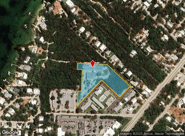
48 High Point Rd, Tavernier, FL 33070
Property Detail
48 High Point Rd
00418880-000100
PT LT 9 AND PT LT 13 AND PT LT 9 AND PT LT 13 AND PT PRIVATE LANE (4 X 37.67) RANDALL ADAMS SUBD PB1-110 PLANTATION KEY OR547-537 OR547-562E OR547-567 OR557-255 OR608-820E OR881-2134/2135 OR881-2137/2138 OR881-2140/2144Q/C OR881-2145/2147Q/C OR928-73
Hospitalprivate
MONROE
UR
Florida
AE The base floodplain where base flood elevations are provided. AE Zones are now used on new format FIRMs instead of A1-A30 Zones.
9,13
0
2.45 AC
2025
Upper Florida Keys
970800
Other Market Areas
39,171 SF
Key West-Key Largo, FL
NEARBY LISTINGS FOR SALE OR LEASE
-
-
View all Tavernier listings for sale on LoopNet.com
DEMOGRAPHICS near 48 High Point Rd
1 mile
3 mile
5 mile
2025 Total Population
1,504
5,727
7,913
2030 Population
1,518
5,755
7,919
Pop Growth 2025-2030
+ 0.93%
+ 0.49%
+ 0.08%
Average Age
49
49
48
2025 Total Households
670
2,560
3,552
HH Growth 2025-2030
+ 0.90%
+ 0.43%
(0.03%)
Median Household Inc
$101,667
$96,829
$87,243
Avg Household Size
2.20
2.20
2.20
2025 Avg HH Vehicles
2.00
2.00
2.00
Median Home Value
$807,209
$832,969
$802,803
Median Year Built
1981
1981
1981
Nearby Places
Map Layers
Map Styles
 Street
 Aerial
Layers
 Traffic
 Biking
Places
Listings with unknown addresses are not visible on the map
- Restaurants
- Banks
- Shops
- Fitness
- Groceries
Nearby Properties
Address
Land Use
TOTAL SIZE
Lot Size
Zoning
Address
Land Use
TOTAL SIZE
Lot Size
Zoning
180,730 SF
19.61 AC
SR
Address
Land Use
TOTAL SIZE
Lot Size
Zoning
112,679 SF
12.09 AC
UC
Address
Land Use
TOTAL SIZE
Lot Size
Zoning
97,143 SF
7.20 AC
SC
Address
Land Use
TOTAL SIZE
Lot Size
Zoning
50,461 SF
7.49 AC
URM
Address
Land Use
TOTAL SIZE
Lot Size
Zoning
111,629 SF
8.30 AC
UC
Address
Land Use
TOTAL SIZE
Lot Size
Zoning
79,452 SF
3.01 AC
SC
Address
Land Use
TOTAL SIZE
Lot Size
Zoning
80,559 SF
8.54 AC
UC
Address
Land Use
TOTAL SIZE
Lot Size
Zoning
29,330 SF
2.28 AC
SC
Address
Land Use
TOTAL SIZE
Lot Size
Zoning
12,855 SF
2.28 AC
URM
Address
Land Use
TOTAL SIZE
Lot Size
Zoning
72,766 SF
9.78 AC
SR
Address
Land Use
TOTAL SIZE
Lot Size
Zoning
4,075 SF
2.49 AC
SC
Address
Land Use
TOTAL SIZE
Lot Size
Zoning
5,342 SF
3.84 AC
NA
Address
Land Use
TOTAL SIZE
Lot Size
Zoning
2.05 AC
SR
Address
Land Use
TOTAL SIZE
Lot Size
Zoning
9,825 SF
1.34 AC
IS-D
Address
Land Use
TOTAL SIZE
Lot Size
Zoning
3,698 SF
3.06 AC
SC
Address
Land Use
TOTAL SIZE
Lot Size
Zoning
18,480 SF
0.86 AC
SC
Address
Land Use
TOTAL SIZE
Lot Size
Zoning
0.87 AC
NA
Address
Land Use
TOTAL SIZE
Lot Size
Zoning
2,920 SF
0.17 AC
SC
Address
Land Use
TOTAL SIZE
Lot Size
Zoning
2,571 SF
0.59 AC
IS
Address
Land Use
TOTAL SIZE
Lot Size
Zoning
2,320 SF
0.52 AC
SC
Address
Land Use
TOTAL SIZE
Lot Size
Zoning
10,002 SF
17.87 AC
DR
Address
Land Use
TOTAL SIZE
Lot Size
Zoning
3,616 SF
2.09 AC
SC
Address
Land Use
TOTAL SIZE
Lot Size
Zoning
5,529 SF
0.67 AC
IS-M
Address
Land Use
TOTAL SIZE
Lot Size
Zoning
6,514 SF
0.38 AC
CFA
Address
Land Use
TOTAL SIZE
Lot Size
Zoning
1,800 SF
0.45 AC
SR
Address
Land Use
TOTAL SIZE
Lot Size
Zoning
2,013 SF
0.28 AC
SR
Address
Land Use
TOTAL SIZE
Lot Size
Zoning
4,688 SF
0.28 AC
IS
Address
Land Use
TOTAL SIZE
Lot Size
Zoning
11,126 SF
0.23 AC
MU
Address
Land Use
TOTAL SIZE
Lot Size
Zoning
2,100 SF
2.16 AC
SS
The World's #1 Commercial Real Estate Marketplace
Connect with us
© 2026 CoStar Group
The information above has been obtained from sources believed reliable. While we do not doubt its accuracy we have not verified it and make no guarantee, warranty or representation about it. It is your responsibility to independently confirm its accuracy and completeness. Any projections, opinions, assumptions, or estimates used are for example only and do not represent the current or future performance of the property. The value of this transaction to you depends on tax and other factors which should be evaluated by your tax, financial, and legal advisors. You and your advisors should conduct a careful, independent investigation of the property to determine to your satisfaction the suitability of the property for your needs.