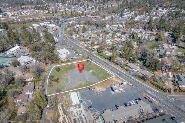
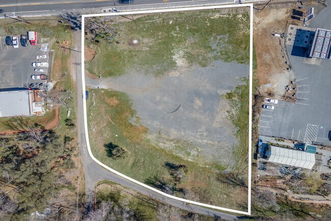
Property Record
48 E Highway 4, Copperopolis, CA 95228


Property Detail
48 E Highway 4
066-004-075-000
MURPHYS TWST ADJ PCL 2 OF PM 10-28 IN 8 T3NR14E
Residentialacreage
CALAVERAS
C2
California
B and X Area of moderate flood hazard, usually the area between the limits of the 100-year and 500-year floods.
1.93 AC
2025
Merced/Central
2025
Other Market Areas
000123
NEARBY LISTINGS FOR SALE OR LEASE
-
-
View all Copperopolis listings for sale on LoopNet.com
DEMOGRAPHICS near 48 E Highway 4
1 mile
3 mile
5 mile
2024 Total Population
1,943
2,907
5,193
2029 Population
2,071
3,055
5,424
Pop Growth 2024-2029
+ 6.59%
+ 5.09%
+ 4.45%
Average Age
52
50
50
2024 Total Households
950
1,336
2,313
HH Growth 2024-2029
+ 6.21%
+ 4.79%
+ 4.06%
Median Household Inc
$43,166
$48,581
$58,220
Avg Household Size
2.00
2.10
2.20
2024 Avg HH Vehicles
2.00
2.00
2.00
Median Home Value
$340,530
$369,651
$400,459
Median Year Built
1986
1985
1987
Nearby Places
Map Layers
Map Styles
 Street
 Aerial
Transit
 Traffic
 Biking
Places
Listings with unknown addresses are not visible on the map
- Restaurants
- Banks
- Shops
- Fitness
- Groceries
SALE & LEASE HISTORY
LISTING DATE
SALE/LEASE

Mar 09, 2022
For Sale
Nearby Properties
Address
Land Use
TOTAL SIZE
Lot Size
Zoning
Address
Land Use
TOTAL SIZE
Lot Size
Zoning
267 AC
A120
Address
Land Use
TOTAL SIZE
Lot Size
Zoning
44,898 SF
2.04 AC
C2PX
Address
Land Use
TOTAL SIZE
Lot Size
Zoning
1,792 SF
5.92 AC
UHS
Address
Land Use
TOTAL SIZE
Lot Size
Zoning
8,448 SF
1.21 AC
C1
Address
Land Use
TOTAL SIZE
Lot Size
Zoning
0.70 AC
C1
Address
Land Use
TOTAL SIZE
Lot Size
Zoning
5,398 SF
33.37 AC
A1X
Address
Land Use
TOTAL SIZE
Lot Size
Zoning
6,043 SF
24.82 AC
RRPD
Address
Land Use
TOTAL SIZE
Lot Size
Zoning
6,039 SF
38.09 AC
U
Address
Land Use
TOTAL SIZE
Lot Size
Zoning
4,618 SF
40.55 AC
A120
Address
Land Use
TOTAL SIZE
Lot Size
Zoning
1.35 AC
C2
Address
Land Use
TOTAL SIZE
Lot Size
Zoning
3,991 SF
153.15 AC
RA20
Address
Land Use
TOTAL SIZE
Lot Size
Zoning
4,491 SF
73.55 AC
RR5
Address
Land Use
TOTAL SIZE
Lot Size
Zoning
4,017 SF
6.38 AC
U
Address
Land Use
TOTAL SIZE
Lot Size
Zoning
2,772 SF
0.42 AC
C1
Address
Land Use
TOTAL SIZE
Lot Size
Zoning
4,000 SF
0.70 AC
C24800
Address
Land Use
TOTAL SIZE
Lot Size
Zoning
0.90 AC
Address
Land Use
TOTAL SIZE
Lot Size
Zoning
2,768 SF
18.76 AC
RR5
Address
Land Use
TOTAL SIZE
Lot Size
Zoning
2,522 SF
7.51 AC
RRX
Address
Land Use
TOTAL SIZE
Lot Size
Zoning
7.52 AC
Address
Land Use
TOTAL SIZE
Lot Size
Zoning
12.44 AC
A1
Address
Land Use
TOTAL SIZE
Lot Size
Zoning
0.44 AC
CP
Address
Land Use
TOTAL SIZE
Lot Size
Zoning
8,066 SF
5.36 AC
CP
Address
Land Use
TOTAL SIZE
Lot Size
Zoning
3,987 SF
8.48 AC
RRX
Address
Land Use
TOTAL SIZE
Lot Size
Zoning
35.05 AC
Address
Land Use
TOTAL SIZE
Lot Size
Zoning
3,386 SF
39.52 AC
U
Address
Land Use
TOTAL SIZE
Lot Size
Zoning
118.25 AC
AP
Address
Land Use
TOTAL SIZE
Lot Size
Zoning
4,016 SF
10.05 AC
RRX
Address
Land Use
TOTAL SIZE
Lot Size
Zoning
2,650 SF
40.14 AC
U
Address
Land Use
TOTAL SIZE
Lot Size
Zoning
3,888 SF
5.04 AC
RR5
Address
Land Use
TOTAL SIZE
Lot Size
Zoning
5 AC
RR5
The World's #1 Commercial Real Estate Marketplace
Connect with us
© 2026 CoStar Group
The information above has been obtained from sources believed reliable. While we do not doubt its accuracy we have not verified it and make no guarantee, warranty or representation about it. It is your responsibility to independently confirm its accuracy and completeness. Any projections, opinions, assumptions, or estimates used are for example only and do not represent the current or future performance of the property. The value of this transaction to you depends on tax and other factors which should be evaluated by your tax, financial, and legal advisors. You and your advisors should conduct a careful, independent investigation of the property to determine to your satisfaction the suitability of the property for your needs.