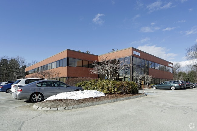
Property Record
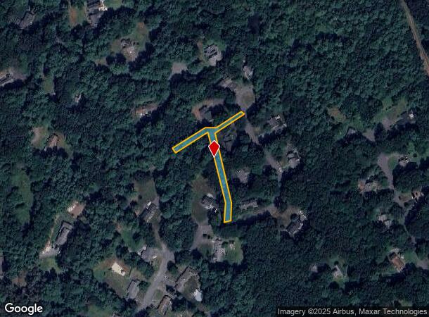
48 Kinsman Cir, Topsfield, MA 01983


NEARBY LISTINGS FOR SALE OR LEASE
-
-
View all Topsfield listings for lease on LoopNet.com
Property Detail
48 Kinsman Cir
METH-000318-000165-A000009A
Essex
Governmentalpublicusegeneral
Massachusetts
X
0.33 AC
25009C0264G
Lawrence/Andover
0
Boston
2025
Boston-Cambridge-Newton, MA-NH
214100
DEMOGRAPHICS near 48 Kinsman Cir
1 Mile
3 Mile
5 Mile
2024 Total Population
2,817
47,901
200,902
2029 Population
2,809
47,220
197,856
Pop Growth 2024-2029
(0.28%)
(1.42%)
(1.52%)
Average Age
43
39
39
2024 Total Households
1,073
16,379
70,741
HH Growth 2024-2029
(0.37%)
(1.50%)
(1.48%)
Median Household Inc
$131,848
$88,666
$74,516
Avg Household Size
2.60
2.80
2.70
2024 Avg HH Vehicles
2.00
2.00
2.00
Median Home Value
$680,280
$477,640
$441,926
Median Year Built
1986
1970
1961
Nearby Places
Map Layers
Map Styles
 Street
 Aerial
- Restaurants
- Banks
- Shops
- Fitness
- Groceries
PUBLIC TRANSPORTATION
COMMUTER RAIL
Hamilton/Wenham (Newburyport/Rockport Line - Massachusetts Bay Transportation Authority Commuter Rail (Purple Line))
DRIVE
WALK
Distance
Hamilton/Wenham (Newburyport/Rockport Line - Massachusetts Bay Transportation Authority Commuter Rail (Purple Line))
16 min
7.4 mi
North Beverly (Newburyport/Rockport Line - Massachusetts Bay Transportation Authority Commuter Rail (Purple Line))
DRIVE
WALK
Distance
North Beverly (Newburyport/Rockport Line - Massachusetts Bay Transportation Authority Commuter Rail (Purple Line))
16 min
8.0 mi
AIRPORT
General Edward Lawrence Logan International
DRIVE
WALK
Distance
General Edward Lawrence Logan International
38 min
23.2 mi
Freight Ports
Port of Boston
DRIVE
WALK
Distance
Port of Boston
41 min
26.2 mi
SALE & LEASE HISTORY
LISTING DATE
SALE/LEASE

Sep 09, 2022
For Lease
Nearby Properties
Address
Land Use
TOTAL SIZE
Lot Size
Zoning
Address
Land Use
TOTAL SIZE
Lot Size
Zoning
374,769 SF
71.70 AC
Address
Land Use
TOTAL SIZE
Lot Size
Zoning
2,714 SF
6.73 AC
Address
Land Use
TOTAL SIZE
Lot Size
Zoning
198.01 AC
ORA
Address
Land Use
TOTAL SIZE
Lot Size
Zoning
159 AC
RRA
Address
Land Use
TOTAL SIZE
Lot Size
Zoning
1,157 SF
7.62 AC
ORA
Address
Land Use
TOTAL SIZE
Lot Size
Zoning
4,035 SF
760.37 AC
IRA
Address
Land Use
TOTAL SIZE
Lot Size
Zoning
57,011 SF
14.14 AC
IRA
Address
Land Use
TOTAL SIZE
Lot Size
Zoning
8.74 AC
IRA
Address
Land Use
TOTAL SIZE
Lot Size
Zoning
2,213 SF
7.73 AC
Address
Land Use
TOTAL SIZE
Lot Size
Zoning
163.54 AC
Address
Land Use
TOTAL SIZE
Lot Size
Zoning
212.80 AC
RRA
Address
Land Use
TOTAL SIZE
Lot Size
Zoning
53,265 SF
11.29 AC
CR
Address
Land Use
TOTAL SIZE
Lot Size
Zoning
15.20 AC
ORA
Address
Land Use
TOTAL SIZE
Lot Size
Zoning
61 AC
ORA
Address
Land Use
TOTAL SIZE
Lot Size
Zoning
7.39 AC
CR
Address
Land Use
TOTAL SIZE
Lot Size
Zoning
4.80 AC
BP
Address
Land Use
TOTAL SIZE
Lot Size
Zoning
6,358 SF
3.37 AC
Address
Land Use
TOTAL SIZE
Lot Size
Zoning
4,000 SF
158.78 AC
ORA
Address
Land Use
TOTAL SIZE
Lot Size
Zoning
130 AC
ORA
Address
Land Use
TOTAL SIZE
Lot Size
Zoning
2,244 SF
60.40 AC
IRA
Address
Land Use
TOTAL SIZE
Lot Size
Zoning
28 AC
RRA
Address
Land Use
TOTAL SIZE
Lot Size
Zoning
12,024 SF
0.94 AC
CR
Address
Land Use
TOTAL SIZE
Lot Size
Zoning
3.59 AC
BV
Address
Land Use
TOTAL SIZE
Lot Size
Zoning
8.13 AC
IRA
Address
Land Use
TOTAL SIZE
Lot Size
Zoning
27,356 SF
5 AC
LI
Address
Land Use
TOTAL SIZE
Lot Size
Zoning
55.88 AC
Address
Land Use
TOTAL SIZE
Lot Size
Zoning
1.50 AC
BV
Address
Land Use
TOTAL SIZE
Lot Size
Zoning
4 AC
IRA
Address
Land Use
TOTAL SIZE
Lot Size
Zoning
2.73 AC
BH
Address
Land Use
TOTAL SIZE
Lot Size
Zoning
28,304 SF
5.26 AC
LI
The World's #1 Commercial Real Estate Marketplace
Connect with us
© 2025 CoStar Group
The information above has been obtained from sources believed reliable. While we do not doubt its accuracy we have not verified it and make no guarantee, warranty or representation about it. It is your responsibility to independently confirm its accuracy and completeness. Any projections, opinions, assumptions, or estimates used are for example only and do not represent the current or future performance of the property. The value of this transaction to you depends on tax and other factors which should be evaluated by your tax, financial, and legal advisors. You and your advisors should conduct a careful, independent investigation of the property to determine to your satisfaction the suitability of the property for your needs.