Property Record
48 Main St, Ashland, NH 03217
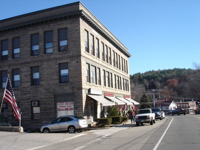

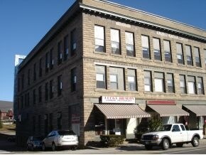
Property Detail
48 Main St
ASHN-000016-000002-000003
GRAFTON
Storebuilding
New Hampshire
B and X Area of moderate flood hazard, usually the area between the limits of the 100-year and 500-year floods.
3
2024
0.32 AC
2024
Concord/New Hampshire North Area
961101
Other Market Areas
22,764 SF
Lebanon-Claremont, NH-VT
NEARBY LISTINGS FOR SALE OR LEASE
-
-
View all Ashland listings for sale on LoopNet.com
DEMOGRAPHICS near 48 Main St
1 mile
3 mile
5 mile
2025 Total Population
1,031
2,366
5,468
2030 Population
979
2,301
5,356
Pop Growth 2025-2030
(5.04%)
(2.75%)
(2.05%)
Average Age
46
47
46
2025 Total Households
495
1,081
2,343
HH Growth 2025-2030
(5.05%)
(2.96%)
(2.26%)
Median Household Inc
$52,301
$61,336
$75,669
Avg Household Size
2.10
2.10
2.20
2025 Avg HH Vehicles
2.00
2.00
2.00
Median Home Value
$212,308
$302,941
$363,389
Median Year Built
1976
1981
1981
Nearby Places
Map Layers
Map Styles
 Street
 Aerial
Layers
 Traffic
 Biking
Places
Listings with unknown addresses are not visible on the map
- Restaurants
- Banks
- Shops
- Fitness
- Groceries
Nearby Properties
Address
Land Use
TOTAL SIZE
Lot Size
Zoning
Address
Land Use
TOTAL SIZE
Lot Size
Zoning
6.80 AC
Address
Land Use
TOTAL SIZE
Lot Size
Zoning
2,356 SF
94 AC
Address
Land Use
TOTAL SIZE
Lot Size
Zoning
Address
Land Use
TOTAL SIZE
Lot Size
Zoning
39,978 SF
19.29 AC
Address
Land Use
TOTAL SIZE
Lot Size
Zoning
1,859 SF
2.60 AC
106 LI
Address
Land Use
TOTAL SIZE
Lot Size
Zoning
11,588 SF
309.17 AC
104 WH
Address
Land Use
TOTAL SIZE
Lot Size
Zoning
3,697 SF
1.40 AC
106 LI
Address
Land Use
TOTAL SIZE
Lot Size
Zoning
4,950 SF
40.10 AC
Address
Land Use
TOTAL SIZE
Lot Size
Zoning
17,759 SF
9.90 AC
Address
Land Use
TOTAL SIZE
Lot Size
Zoning
4,131 SF
1.77 AC
106 LI
Address
Land Use
TOTAL SIZE
Lot Size
Zoning
4,054 SF
1 AC
COMM W
Address
Land Use
TOTAL SIZE
Lot Size
Zoning
62,490 SF
9 AC
Address
Land Use
TOTAL SIZE
Lot Size
Zoning
18,847 SF
7.40 AC
Address
Land Use
TOTAL SIZE
Lot Size
Zoning
Address
Land Use
TOTAL SIZE
Lot Size
Zoning
634 SF
4.50 AC
106 LI
Address
Land Use
TOTAL SIZE
Lot Size
Zoning
22,518 SF
3.95 AC
Address
Land Use
TOTAL SIZE
Lot Size
Zoning
15,926 SF
1.23 AC
Address
Land Use
TOTAL SIZE
Lot Size
Zoning
10,873 SF
3.62 AC
Address
Land Use
TOTAL SIZE
Lot Size
Zoning
1,797 SF
45.54 AC
300 DO
Address
Land Use
TOTAL SIZE
Lot Size
Zoning
716 SF
1.10 AC
106 LI
Address
Land Use
TOTAL SIZE
Lot Size
Zoning
5,626 SF
3.85 AC
Address
Land Use
TOTAL SIZE
Lot Size
Zoning
4,598 SF
14.43 AC
104 WH
Address
Land Use
TOTAL SIZE
Lot Size
Zoning
1,006 SF
2 AC
Address
Land Use
TOTAL SIZE
Lot Size
Zoning
7,117 SF
2.66 AC
Address
Land Use
TOTAL SIZE
Lot Size
Zoning
54,080 SF
7.96 AC
AGRICU
Address
Land Use
TOTAL SIZE
Lot Size
Zoning
715 SF
0.64 AC
106 LI
Address
Land Use
TOTAL SIZE
Lot Size
Zoning
3,215 SF
2.30 AC
106 LI
Address
Land Use
TOTAL SIZE
Lot Size
Zoning
400 SF
28.40 AC
106 LI
Address
Land Use
TOTAL SIZE
Lot Size
Zoning
7,800 SF
2.28 AC
Address
Land Use
TOTAL SIZE
Lot Size
Zoning
2,136 SF
1 AC
The World's #1 Commercial Real Estate Marketplace
Connect with us
© 2026 CoStar Group
The information above has been obtained from sources believed reliable. While we do not doubt its accuracy we have not verified it and make no guarantee, warranty or representation about it. It is your responsibility to independently confirm its accuracy and completeness. Any projections, opinions, assumptions, or estimates used are for example only and do not represent the current or future performance of the property. The value of this transaction to you depends on tax and other factors which should be evaluated by your tax, financial, and legal advisors. You and your advisors should conduct a careful, independent investigation of the property to determine to your satisfaction the suitability of the property for your needs.