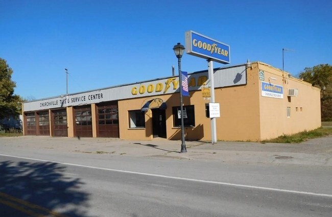
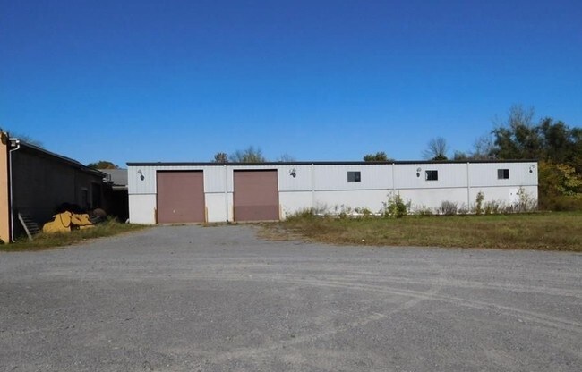
Property Record
48 S Main St, Churchville, NY 14428

NEARBY LISTINGS FOR SALE OR LEASE
Property Detail
48 S Main St
Rochester, NY
Monroe
264801 143.13-3-20.11
New York
Stripcommercialcenter
20.110
2025
2.49 AC
2024
Southwest
015000
Rochester
6,800 SF
DEMOGRAPHICS near 48 S Main St
1 Mile
3 Mile
5 Mile
2024 Total Population
2,281
5,364
20,047
2029 Population
2,234
5,258
19,768
Pop Growth 2024-2029
(2.06%)
(1.98%)
(1.39%)
Average Age
44
44
42
2024 Total Households
1,029
2,222
8,007
HH Growth 2024-2029
(2.14%)
(2.07%)
(1.41%)
Median Household Inc
$79,009
$84,283
$75,159
Avg Household Size
2.20
2.40
2.40
2024 Avg HH Vehicles
2.00
2.00
2.00
Median Home Value
$164,438
$186,407
$184,030
Median Year Built
1975
1976
1981
Nearby Places
Map Layers
Map Styles
 Street
 Aerial
- Restaurants
- Banks
- Shops
- Fitness
- Groceries
PUBLIC TRANSPORTATION
AIRPORT
Frederick Douglass/Greater Rochester International
DRIVE
WALK
Distance
Frederick Douglass/Greater Rochester International
21 min
13.5 mi
SALE & LEASE HISTORY
LISTING DATE
SALE/LEASE

Sep 24, 2016
For Sale
Oct 26, 2017
For Sale
Nov 08, 2016
For Sale
Dec 15, 2016
For Lease
Nearby Properties
Address
Land Use
TOTAL SIZE
Lot Size
Zoning
Address
Land Use
TOTAL SIZE
Lot Size
Zoning
226,634 SF
28.10 AC
05 - COMME
Address
Land Use
TOTAL SIZE
Lot Size
Zoning
174,358 SF
51.30 AC
02 - SINGL
Address
Land Use
TOTAL SIZE
Lot Size
Zoning
3,572 SF
717.29 AC
02 - SINGL
Address
Land Use
TOTAL SIZE
Lot Size
Zoning
8,252 SF
8.73 AC
02 - SINGL
Address
Land Use
TOTAL SIZE
Lot Size
Zoning
21,001 SF
18.45 AC
05 - COMME
Address
Land Use
TOTAL SIZE
Lot Size
Zoning
60,725 SF
23.20 AC
05 - COMME
Address
Land Use
TOTAL SIZE
Lot Size
Zoning
47,550 SF
16.21 AC
05 - COMME
Address
Land Use
TOTAL SIZE
Lot Size
Zoning
38.10 AC
Address
Land Use
TOTAL SIZE
Lot Size
Zoning
41,800 SF
16.30 AC
05 - COMME
Address
Land Use
TOTAL SIZE
Lot Size
Zoning
14,681 SF
3.37 AC
08 - GOVER
Address
Land Use
TOTAL SIZE
Lot Size
Zoning
48,000 SF
5.43 AC
06 - INDUS
Address
Land Use
TOTAL SIZE
Lot Size
Zoning
15,016 SF
6.89 AC
05 - COMME
Address
Land Use
TOTAL SIZE
Lot Size
Zoning
54,500 SF
13.44 AC
06 - INDUS
Address
Land Use
TOTAL SIZE
Lot Size
Zoning
99.56 AC
05
Address
Land Use
TOTAL SIZE
Lot Size
Zoning
288 SF
5.70 AC
02 - SINGL
Address
Land Use
TOTAL SIZE
Lot Size
Zoning
19.50 AC
Address
Land Use
TOTAL SIZE
Lot Size
Zoning
2,125 SF
85.60 AC
R-1
Address
Land Use
TOTAL SIZE
Lot Size
Zoning
17.70 AC
Address
Land Use
TOTAL SIZE
Lot Size
Zoning
21,950 SF
2.90 AC
05 - COMME
Address
Land Use
TOTAL SIZE
Lot Size
Zoning
9,100 SF
5.30 AC
05 - COMME
Address
Land Use
TOTAL SIZE
Lot Size
Zoning
16,234 SF
5.73 AC
06 - INDUS
Address
Land Use
TOTAL SIZE
Lot Size
Zoning
147.60 AC
04 - FARM
Address
Land Use
TOTAL SIZE
Lot Size
Zoning
3,000 SF
5.69 AC
05 - COMME
Address
Land Use
TOTAL SIZE
Lot Size
Zoning
31,384 SF
2.50 AC
05 - COMME
Address
Land Use
TOTAL SIZE
Lot Size
Zoning
33.32 AC
05 - COMME
Address
Land Use
TOTAL SIZE
Lot Size
Zoning
4,743 SF
1.29 AC
05 - COMME
Address
Land Use
TOTAL SIZE
Lot Size
Zoning
24,867 SF
3.60 AC
05 - COMME
Address
Land Use
TOTAL SIZE
Lot Size
Zoning
1,692 SF
1 AC
08 - GOVER
Address
Land Use
TOTAL SIZE
Lot Size
Zoning
20,088 SF
3.28 AC
The World's #1 Commercial Real Estate Marketplace
Connect with us
© 2026 CoStar Group
The information above has been obtained from sources believed reliable. While we do not doubt its accuracy we have not verified it and make no guarantee, warranty or representation about it. It is your responsibility to independently confirm its accuracy and completeness. Any projections, opinions, assumptions, or estimates used are for example only and do not represent the current or future performance of the property. The value of this transaction to you depends on tax and other factors which should be evaluated by your tax, financial, and legal advisors. You and your advisors should conduct a careful, independent investigation of the property to determine to your satisfaction the suitability of the property for your needs.