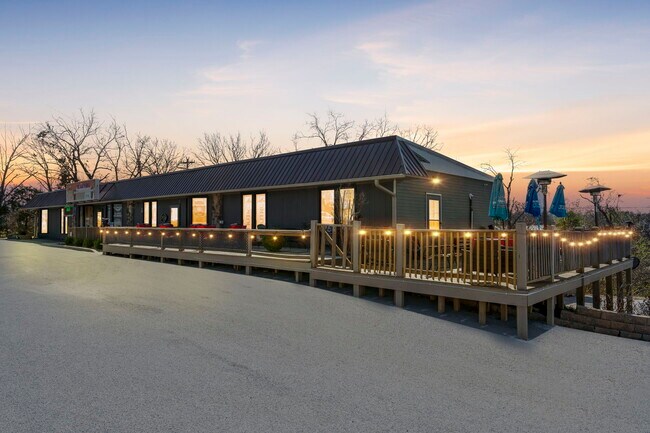
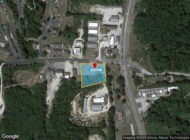
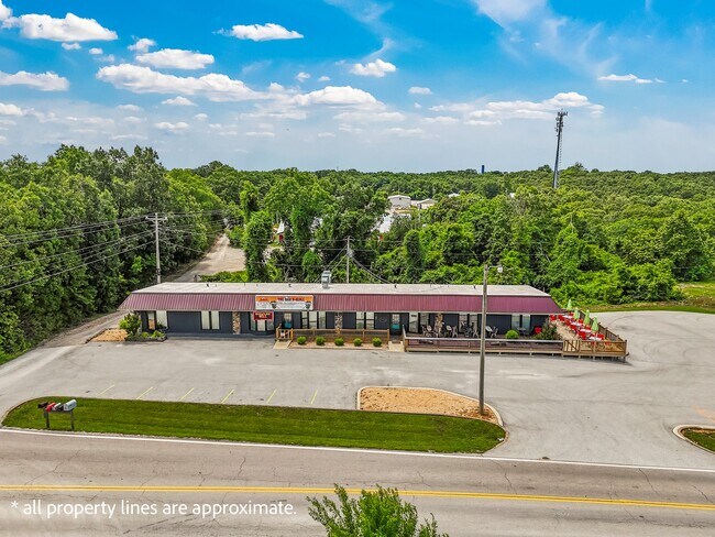
Property Record
48 State Highway Oo, Reeds Spring, MO 65737
NEARBY LISTINGS FOR SALE OR LEASE
Property Detail
48 State Highway Oo
11-8.0-27-000-000-055.000
COM AT A POINT 831.2 FEET N FROM THE SW COR OF SW 1/4 SW 1/4; TH ELY 124.79 FEET TO THE POB. TH ALONG R/W TO THE NW COR OF NICKERSON CEMETERY; SWLY ALONG W LINE OF CEMETERY 175 FEET; SW TO A POINT WHICH IS S 263.24 FEET FROM POB; TH N 263.24 FEET TO
Restaurantbuilding
Stone
X
Missouri
29209C0195D
1.09 AC
2024
Branson
2025
Other Market Areas
090502
Branson, MO
3,638 SF
DEMOGRAPHICS near 48 State Highway Oo
1 Mile
3 Mile
5 Mile
2024 Total Population
687
5,413
11,339
2029 Population
738
5,886
12,520
Pop Growth 2024-2029
+ 7.42%
+ 8.74%
+ 10.42%
Average Age
49
51
52
2024 Total Households
290
2,386
5,082
HH Growth 2024-2029
+ 6.55%
+ 7.92%
+ 9.78%
Median Household Inc
$53,750
$58,610
$59,614
Avg Household Size
2.20
2.20
2.10
2024 Avg HH Vehicles
2.00
2.00
2.00
Median Home Value
$200,893
$218,038
$235,906
Median Year Built
1988
1988
1992
Nearby Places
Map Layers
Map Styles
 Street
 Aerial
- Restaurants
- Banks
- Shops
- Fitness
- Groceries
SALE & LEASE HISTORY
LISTING DATE
SALE/LEASE

Jun 26, 2025
For Sale
Apr 29, 2024
For Sale
Nearby Properties
Address
Land Use
TOTAL SIZE
Lot Size
Zoning
Address
Land Use
TOTAL SIZE
Lot Size
Zoning
Address
Land Use
TOTAL SIZE
Lot Size
Zoning
20,653 SF
2.89 AC
NA
Address
Land Use
TOTAL SIZE
Lot Size
Zoning
11,180 SF
7.03 AC
NA
Address
Land Use
TOTAL SIZE
Lot Size
Zoning
47,094 SF
4.90 AC
NA
Address
Land Use
TOTAL SIZE
Lot Size
Zoning
4,000 SF
5.06 AC
NA
Address
Land Use
TOTAL SIZE
Lot Size
Zoning
12,104 SF
2.11 AC
NA
Address
Land Use
TOTAL SIZE
Lot Size
Zoning
7,088 SF
1.98 AC
C-2
Address
Land Use
TOTAL SIZE
Lot Size
Zoning
10,080 SF
2.12 AC
NA
Address
Land Use
TOTAL SIZE
Lot Size
Zoning
77,252 SF
36.08 AC
A-1
Address
Land Use
TOTAL SIZE
Lot Size
Zoning
5,168 SF
3.14 AC
NA
Address
Land Use
TOTAL SIZE
Lot Size
Zoning
8,997 SF
2.50 AC
NA
Address
Land Use
TOTAL SIZE
Lot Size
Zoning
6,114 SF
4 AC
NA
Address
Land Use
TOTAL SIZE
Lot Size
Zoning
6,360 SF
1.13 AC
NA
Address
Land Use
TOTAL SIZE
Lot Size
Zoning
11,860 SF
5.40 AC
C-2
Address
Land Use
TOTAL SIZE
Lot Size
Zoning
60,580 SF
0.33 AC
NA
Address
Land Use
TOTAL SIZE
Lot Size
Zoning
13,082 SF
0.93 AC
NA
Address
Land Use
TOTAL SIZE
Lot Size
Zoning
8,915 SF
3.27 AC
C-2
Address
Land Use
TOTAL SIZE
Lot Size
Zoning
11,535 SF
1.38 AC
NA
Address
Land Use
TOTAL SIZE
Lot Size
Zoning
21,150 SF
3.41 AC
NA
Address
Land Use
TOTAL SIZE
Lot Size
Zoning
30,924 SF
3.20 AC
NA
Address
Land Use
TOTAL SIZE
Lot Size
Zoning
2,384 SF
12.50 AC
NA
Address
Land Use
TOTAL SIZE
Lot Size
Zoning
30,783 SF
19 AC
C-2
Address
Land Use
TOTAL SIZE
Lot Size
Zoning
4,475 SF
1.02 AC
NA
Address
Land Use
TOTAL SIZE
Lot Size
Zoning
5,350 SF
1.25 AC
NA
Address
Land Use
TOTAL SIZE
Lot Size
Zoning
155 SF
3.80 AC
Address
Land Use
TOTAL SIZE
Lot Size
Zoning
4,136 SF
2.20 AC
RR-1
Address
Land Use
TOTAL SIZE
Lot Size
Zoning
25,520 SF
13.33 AC
RR-1
Address
Land Use
TOTAL SIZE
Lot Size
Zoning
6,074 SF
2.95 AC
Address
Land Use
TOTAL SIZE
Lot Size
Zoning
10,687 SF
1.45 AC
C-2
The World's #1 Commercial Real Estate Marketplace
Connect with us
© 2026 CoStar Group
The information above has been obtained from sources believed reliable. While we do not doubt its accuracy we have not verified it and make no guarantee, warranty or representation about it. It is your responsibility to independently confirm its accuracy and completeness. Any projections, opinions, assumptions, or estimates used are for example only and do not represent the current or future performance of the property. The value of this transaction to you depends on tax and other factors which should be evaluated by your tax, financial, and legal advisors. You and your advisors should conduct a careful, independent investigation of the property to determine to your satisfaction the suitability of the property for your needs.