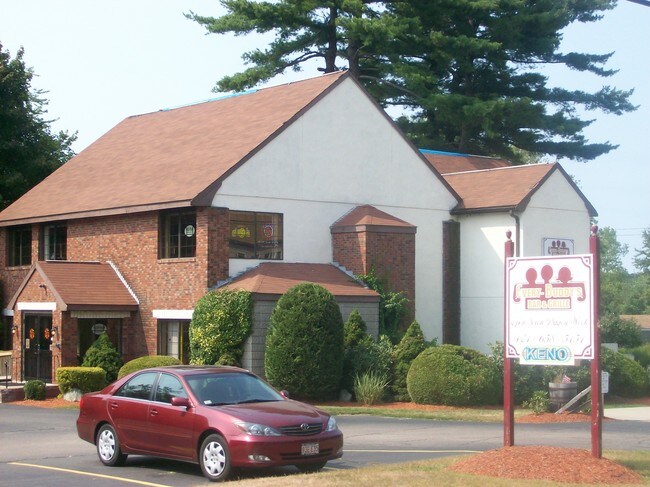
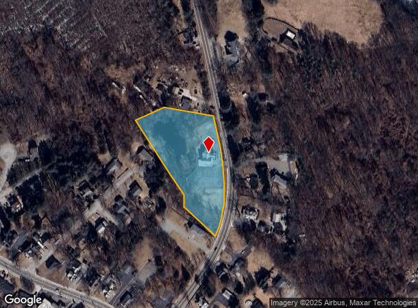
Property Record
48 W Wrentham Rd, Cumberland, RI 02864
NEARBY LISTINGS FOR SALE OR LEASE
Property Detail
48 W Wrentham Rd
Commercialbuilding
Providence
X
Rhode Island
25005C0100F
2.71 AC
2025
Woonsocket
2025
Providence
011403
Providence-Warwick, RI-MA
4,679 SF
CUMB-000052-000343-000000
DEMOGRAPHICS near 48 W Wrentham Rd
1 Mile
3 Mile
5 Mile
2024 Total Population
7,818
46,338
102,985
2029 Population
7,880
46,119
102,433
Pop Growth 2024-2029
+ 0.79%
(0.47%)
(0.54%)
Average Age
41
41
41
2024 Total Households
3,179
19,012
41,489
HH Growth 2024-2029
+ 0.63%
(0.62%)
(0.66%)
Median Household Inc
$90,798
$71,258
$77,457
Avg Household Size
2.40
2.40
2.40
2024 Avg HH Vehicles
2.00
2.00
2.00
Median Home Value
$344,591
$342,781
$360,460
Median Year Built
1979
1964
1964
Nearby Places
Map Layers
Map Styles
 Street
 Aerial
- Restaurants
- Banks
- Shops
- Fitness
- Groceries
PUBLIC TRANSPORTATION
COMMUTER RAIL
DRIVE
WALK
Distance
14 min
8.5 mi
South Attleboro (Providence/Stoughton Line - Massachusetts Bay Transportation Authority Commuter Rail (Purple Line))
DRIVE
WALK
Distance
South Attleboro (Providence/Stoughton Line - Massachusetts Bay Transportation Authority Commuter Rail (Purple Line))
17 min
9.9 mi
AIRPORT
Rhode Island Tf Green International
DRIVE
WALK
Distance
Rhode Island Tf Green International
35 min
22.3 mi
Worcester Regional
DRIVE
WALK
Distance
Worcester Regional
52 min
36.2 mi
Freight Ports
Port of Davisville, RI
DRIVE
WALK
Distance
Port of Davisville, RI
47 min
34.2 mi
SALE & LEASE HISTORY
LISTING DATE
SALE/LEASE

Sep 23, 2016
For Sale
Nearby Properties
Address
Land Use
TOTAL SIZE
Lot Size
Zoning
Address
Land Use
TOTAL SIZE
Lot Size
Zoning
16.88 AC
I1
Address
Land Use
TOTAL SIZE
Lot Size
Zoning
210,008 SF
13.95 AC
C1
Address
Land Use
TOTAL SIZE
Lot Size
Zoning
227,000 SF
6.72 AC
R3
Address
Land Use
TOTAL SIZE
Lot Size
Zoning
41.01 AC
30
Address
Land Use
TOTAL SIZE
Lot Size
Zoning
16.10 AC
60
Address
Land Use
TOTAL SIZE
Lot Size
Zoning
26.54 AC
90
Address
Land Use
TOTAL SIZE
Lot Size
Zoning
7,580 SF
32.61 AC
R4
Address
Land Use
TOTAL SIZE
Lot Size
Zoning
247,708 SF
12.14 AC
ML05
Address
Land Use
TOTAL SIZE
Lot Size
Zoning
17.10 AC
I1
Address
Land Use
TOTAL SIZE
Lot Size
Zoning
11.61 AC
60
Address
Land Use
TOTAL SIZE
Lot Size
Zoning
16.49 AC
PR1
Address
Land Use
TOTAL SIZE
Lot Size
Zoning
1 AC
R4
Address
Land Use
TOTAL SIZE
Lot Size
Zoning
18.49 AC
60
Address
Land Use
TOTAL SIZE
Lot Size
Zoning
175,122 SF
22.44 AC
ML05
Address
Land Use
TOTAL SIZE
Lot Size
Zoning
5,520 SF
9.81 AC
R1
Address
Land Use
TOTAL SIZE
Lot Size
Zoning
10.27 AC
ML05
Address
Land Use
TOTAL SIZE
Lot Size
Zoning
19,774 SF
23.53 AC
R1
Address
Land Use
TOTAL SIZE
Lot Size
Zoning
147,146 SF
28.05 AC
BH
Address
Land Use
TOTAL SIZE
Lot Size
Zoning
8.33 AC
R2
Address
Land Use
TOTAL SIZE
Lot Size
Zoning
157,856 SF
2.13 AC
C2
Address
Land Use
TOTAL SIZE
Lot Size
Zoning
103,520 SF
3.44 AC
BH
Address
Land Use
TOTAL SIZE
Lot Size
Zoning
105,384 SF
17.07 AC
120
Address
Land Use
TOTAL SIZE
Lot Size
Zoning
10.09 AC
RG7
Address
Land Use
TOTAL SIZE
Lot Size
Zoning
72,880 SF
4.30 AC
BH
Address
Land Use
TOTAL SIZE
Lot Size
Zoning
149,422 SF
14.45 AC
60
Address
Land Use
TOTAL SIZE
Lot Size
Zoning
403,844 SF
10.78 AC
I2
Address
Land Use
TOTAL SIZE
Lot Size
Zoning
5.63 AC
R2
Address
Land Use
TOTAL SIZE
Lot Size
Zoning
74,147 SF
19.64 AC
RS12
Address
Land Use
TOTAL SIZE
Lot Size
Zoning
9.28 AC
60
Address
Land Use
TOTAL SIZE
Lot Size
Zoning
96,714 SF
2.11 AC
R4
The World's #1 Commercial Real Estate Marketplace
Connect with us
© 2025 CoStar Group
The information above has been obtained from sources believed reliable. While we do not doubt its accuracy we have not verified it and make no guarantee, warranty or representation about it. It is your responsibility to independently confirm its accuracy and completeness. Any projections, opinions, assumptions, or estimates used are for example only and do not represent the current or future performance of the property. The value of this transaction to you depends on tax and other factors which should be evaluated by your tax, financial, and legal advisors. You and your advisors should conduct a careful, independent investigation of the property to determine to your satisfaction the suitability of the property for your needs.