Property Record
480 Colonial Pw Pkwy, Columbus Grove, OH 45830

NEARBY LISTINGS FOR SALE OR LEASE
Property Detail
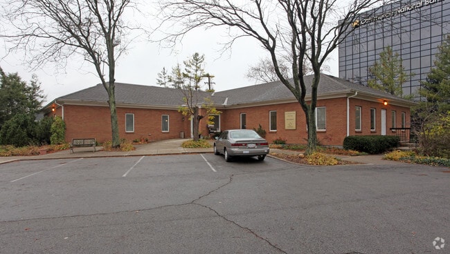
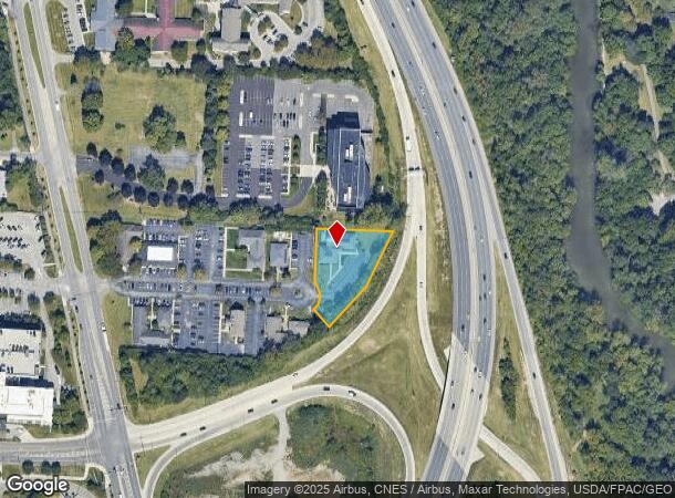
480 Colonial Pw Pkwy
010-146832
Riverview Profession Village
Medicalbuilding
COLONIAL PARKWAY RIVERVIEW PRO VILL RES C .7619 ACRES
X
Franklin
39049C0167K
Ohio
2024
0.76 AC
2024
Grandview/Upper Arlington
030500
Columbus
7,813 SF
Columbus, OH
DEMOGRAPHICS near 480 Colonial Pw Pkwy
1 Mile
3 Mile
5 Mile
2024 Total Population
13,296
144,977
348,235
2029 Population
13,325
144,988
348,857
Pop Growth 2024-2029
+ 0.22%
+ 0.01%
+ 0.18%
Average Age
38
36
36
2024 Total Households
6,405
61,350
149,297
HH Growth 2024-2029
+ 0.30%
0.00%
+ 0.16%
Median Household Inc
$70,008
$62,935
$63,596
Avg Household Size
2.00
2.10
2.20
2024 Avg HH Vehicles
2.00
2.00
2.00
Median Home Value
$351,233
$317,823
$297,631
Median Year Built
1957
1961
1967
Nearby Places
- Restaurants
- Banks
- Shops
- Fitness
- Groceries
PUBLIC TRANSPORTATION
AIRPORT
John Glenn Columbus International
DRIVE
WALK
Distance
John Glenn Columbus International
19 min
11.9 mi
Rickenbacker International
DRIVE
WALK
Distance
Rickenbacker International
31 min
21.2 mi
Freight Ports
Port of Toledo
DRIVE
WALK
Distance
Port of Toledo
177 min
138.9 mi
Nearby Properties
Address
Land Use
TOTAL SIZE
Lot Size
Zoning
Address
Land Use
TOTAL SIZE
Lot Size
Zoning
1,050,853 SF
328.10 AC
Address
Land Use
TOTAL SIZE
Lot Size
Zoning
3,462,019 SF
54.42 AC
Address
Land Use
TOTAL SIZE
Lot Size
Zoning
344,620 SF
291.96 AC
Address
Land Use
TOTAL SIZE
Lot Size
Zoning
Address
Land Use
TOTAL SIZE
Lot Size
Zoning
1,099,074 SF
39.47 AC
Address
Land Use
TOTAL SIZE
Lot Size
Zoning
388,082 SF
12.41 AC
Address
Land Use
TOTAL SIZE
Lot Size
Zoning
1.64 AC
Address
Land Use
TOTAL SIZE
Lot Size
Zoning
611,253 SF
32.89 AC
Address
Land Use
TOTAL SIZE
Lot Size
Zoning
378,522 SF
41.13 AC
Address
Land Use
TOTAL SIZE
Lot Size
Zoning
747,391 SF
3.15 AC
Address
Land Use
TOTAL SIZE
Lot Size
Zoning
4.90 AC
Address
Land Use
TOTAL SIZE
Lot Size
Zoning
2.25 AC
Address
Land Use
TOTAL SIZE
Lot Size
Zoning
240,144 SF
45.78 AC
Address
Land Use
TOTAL SIZE
Lot Size
Zoning
4.46 AC
Address
Land Use
TOTAL SIZE
Lot Size
Zoning
Address
Land Use
TOTAL SIZE
Lot Size
Zoning
34,200 SF
8.10 AC
Address
Land Use
TOTAL SIZE
Lot Size
Zoning
431,360 SF
7.95 AC
Address
Land Use
TOTAL SIZE
Lot Size
Zoning
24.14 AC
Address
Land Use
TOTAL SIZE
Lot Size
Zoning
10,368 SF
293.98 AC
Address
Land Use
TOTAL SIZE
Lot Size
Zoning
339,332 SF
1.42 AC
Address
Land Use
TOTAL SIZE
Lot Size
Zoning
0.99 AC
Address
Land Use
TOTAL SIZE
Lot Size
Zoning
1.39 AC
Address
Land Use
TOTAL SIZE
Lot Size
Zoning
517,875 SF
3.07 AC
Address
Land Use
TOTAL SIZE
Lot Size
Zoning
29,668 SF
1.32 AC
Address
Land Use
TOTAL SIZE
Lot Size
Zoning
255,831 SF
2.50 AC
Address
Land Use
TOTAL SIZE
Lot Size
Zoning
234,504 SF
5.40 AC
Address
Land Use
TOTAL SIZE
Lot Size
Zoning
0.20 AC
Address
Land Use
TOTAL SIZE
Lot Size
Zoning
265,341 SF
19.35 AC
Address
Land Use
TOTAL SIZE
Lot Size
Zoning
247,266 SF
7.85 AC
Address
Land Use
TOTAL SIZE
Lot Size
Zoning
286,169 SF
11.08 AC
The World's #1 Commercial Real Estate Marketplace
Connect with us
© 2025 CoStar Group
The information above has been obtained from sources believed reliable. While we do not doubt its accuracy we have not verified it and make no guarantee, warranty or representation about it. It is your responsibility to independently confirm its accuracy and completeness. Any projections, opinions, assumptions, or estimates used are for example only and do not represent the current or future performance of the property. The value of this transaction to you depends on tax and other factors which should be evaluated by your tax, financial, and legal advisors. You and your advisors should conduct a careful, independent investigation of the property to determine to your satisfaction the suitability of the property for your needs.