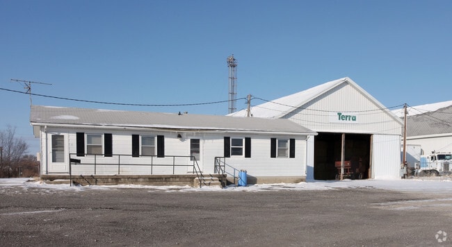
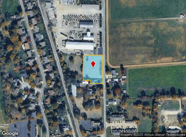
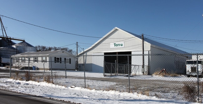
Property Record
480 N Front St, Whiteland, IN 46184
NEARBY LISTINGS FOR SALE OR LEASE
Property Detail
480 N Front St
41-05-22-032-030.000-028
W SW S22 T13 R4
Industrialacreage
Johnson
X
Indiana
18081C0137D
1.29 AC
2024
Johnson County
2025
Indianapolis
610501
Indianapolis-Carmel-Anderson, IN
2,446 SF
DEMOGRAPHICS near 480 N Front St
1 Mile
3 Mile
5 Mile
2024 Total Population
4,042
29,401
81,916
2029 Population
4,354
31,418
87,464
Pop Growth 2024-2029
+ 7.72%
+ 6.86%
+ 6.77%
Average Age
39
37
38
2024 Total Households
1,489
10,296
30,503
HH Growth 2024-2029
+ 7.79%
+ 7.03%
+ 6.94%
Median Household Inc
$73,585
$81,830
$76,855
Avg Household Size
2.70
2.80
2.60
2024 Avg HH Vehicles
2.00
2.00
2.00
Median Home Value
$155,297
$179,740
$205,689
Median Year Built
1991
1998
1996
Nearby Places
Map Layers
Map Styles
 Street
 Aerial
- Restaurants
- Banks
- Shops
- Fitness
- Groceries
PUBLIC TRANSPORTATION
AIRPORT
Indianapolis International
DRIVE
WALK
Distance
Indianapolis International
44 min
26.1 mi
Freight Ports
Port of Toledo
DRIVE
WALK
Distance
Port of Toledo
291 min
242.3 mi
Nearby Properties
Address
Land Use
TOTAL SIZE
Lot Size
Zoning
Address
Land Use
TOTAL SIZE
Lot Size
Zoning
1,057,350 SF
60.62 AC
Address
Land Use
TOTAL SIZE
Lot Size
Zoning
984,410 SF
73.31 AC
Address
Land Use
TOTAL SIZE
Lot Size
Zoning
845,880 SF
45.31 AC
Address
Land Use
TOTAL SIZE
Lot Size
Zoning
1,103,760 SF
84.07 AC
Address
Land Use
TOTAL SIZE
Lot Size
Zoning
997,650 SF
67.25 AC
Address
Land Use
TOTAL SIZE
Lot Size
Zoning
816,376 SF
65.10 AC
Address
Land Use
TOTAL SIZE
Lot Size
Zoning
826,800 SF
62.89 AC
Address
Land Use
TOTAL SIZE
Lot Size
Zoning
34.59 AC
Address
Land Use
TOTAL SIZE
Lot Size
Zoning
588,200 SF
44.31 AC
Address
Land Use
TOTAL SIZE
Lot Size
Zoning
530,400 SF
29.63 AC
Address
Land Use
TOTAL SIZE
Lot Size
Zoning
32.60 AC
Address
Land Use
TOTAL SIZE
Lot Size
Zoning
56,100 SF
50.05 AC
Address
Land Use
TOTAL SIZE
Lot Size
Zoning
2,008 SF
9.86 AC
Address
Land Use
TOTAL SIZE
Lot Size
Zoning
136,760 SF
31.47 AC
Address
Land Use
TOTAL SIZE
Lot Size
Zoning
178,880 SF
9.03 AC
Address
Land Use
TOTAL SIZE
Lot Size
Zoning
58,711 SF
13.71 AC
Address
Land Use
TOTAL SIZE
Lot Size
Zoning
168,480 SF
8.42 AC
Address
Land Use
TOTAL SIZE
Lot Size
Zoning
130,440 SF
10.05 AC
Address
Land Use
TOTAL SIZE
Lot Size
Zoning
114,852 SF
8.50 AC
Address
Land Use
TOTAL SIZE
Lot Size
Zoning
20.19 AC
Address
Land Use
TOTAL SIZE
Lot Size
Zoning
7.19 AC
Address
Land Use
TOTAL SIZE
Lot Size
Zoning
15,504 SF
72.69 AC
Address
Land Use
TOTAL SIZE
Lot Size
Zoning
65,600 SF
8.22 AC
Address
Land Use
TOTAL SIZE
Lot Size
Zoning
88,000 SF
26.01 AC
Address
Land Use
TOTAL SIZE
Lot Size
Zoning
88,925 SF
11.24 AC
Address
Land Use
TOTAL SIZE
Lot Size
Zoning
160,700 SF
25.56 AC
Address
Land Use
TOTAL SIZE
Lot Size
Zoning
290,449 SF
22.82 AC
Address
Land Use
TOTAL SIZE
Lot Size
Zoning
36,033 SF
15.12 AC
Address
Land Use
TOTAL SIZE
Lot Size
Zoning
68,423 SF
41.73 AC
Address
Land Use
TOTAL SIZE
Lot Size
Zoning
100,672 SF
25.32 AC
The World's #1 Commercial Real Estate Marketplace
Connect with us
© 2025 CoStar Group
The information above has been obtained from sources believed reliable. While we do not doubt its accuracy we have not verified it and make no guarantee, warranty or representation about it. It is your responsibility to independently confirm its accuracy and completeness. Any projections, opinions, assumptions, or estimates used are for example only and do not represent the current or future performance of the property. The value of this transaction to you depends on tax and other factors which should be evaluated by your tax, financial, and legal advisors. You and your advisors should conduct a careful, independent investigation of the property to determine to your satisfaction the suitability of the property for your needs.