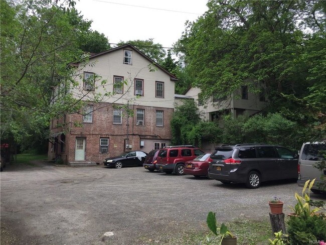
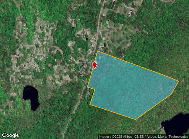
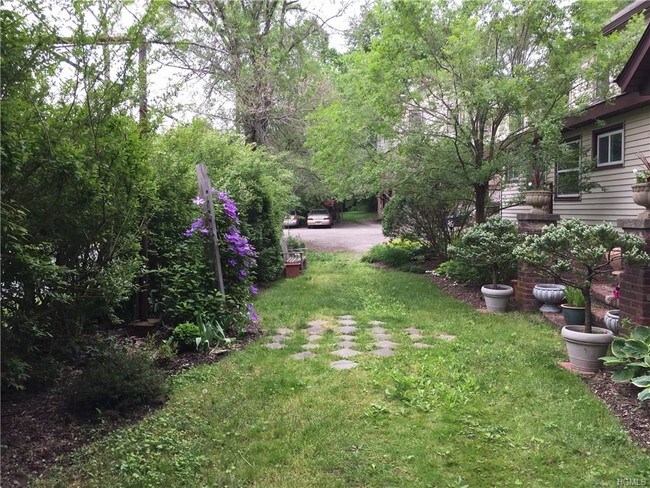
Property Record
480 Route 9D, Beacon, NY 12508
NEARBY LISTINGS FOR SALE OR LEASE
-
-
-
-
No Photo
-
-
-
-
View all Beacon listings for sale on LoopNet.com
Property Detail
480 Route 9D
133089-5953-00-910720-0000
27.5 AC (D) 1667 0360 0523 0240
Apartment
Dutchess
X
New York
36027C0576E
910
2025
27.50 AC
2024
Beacon
060202
Westchester/So Connecticut
9,843 SF
Dutchess County-Putnam County, NY
DEMOGRAPHICS near 480 Route 9D
1 Mile
3 Mile
5 Mile
2024 Total Population
664
33,904
91,939
2029 Population
666
34,324
93,229
Pop Growth 2024-2029
+ 0.30%
+ 1.24%
+ 1.40%
Average Age
47
39
40
2024 Total Households
272
13,132
35,036
HH Growth 2024-2029
+ 0.37%
+ 1.29%
+ 1.45%
Median Household Inc
$105,769
$81,358
$85,478
Avg Household Size
2.40
2.40
2.40
2024 Avg HH Vehicles
2.00
1.00
2.00
Median Home Value
$462,999
$411,634
$385,346
Median Year Built
1972
1950
1961
Nearby Places
Map Layers
Map Styles
 Street
 Aerial
- Restaurants
- Banks
- Shops
- Fitness
- Groceries
PUBLIC TRANSPORTATION
COMMUTER RAIL
Breakneck Ridge Station (Hudson Line - Metro-North Commuter Railroad Company (Metro-North))
DRIVE
WALK
Distance
Breakneck Ridge Station (Hudson Line - Metro-North Commuter Railroad Company (Metro-North))
2 min
1.8 mi
Beacon Station (Hudson Line - Metro-North Commuter Railroad Company (Metro-North))
DRIVE
WALK
Distance
Beacon Station (Hudson Line - Metro-North Commuter Railroad Company (Metro-North))
8 min
3.5 mi
AIRPORT
New York Stewart International
DRIVE
WALK
Distance
New York Stewart International
26 min
13.8 mi
Freight Ports
NY - Red Hook Container Terminal
DRIVE
WALK
Distance
NY - Red Hook Container Terminal
100 min
69.6 mi
SALE & LEASE HISTORY
LISTING DATE
SALE/LEASE

Jun 07, 2017
For Sale
Nearby Properties
Address
Land Use
TOTAL SIZE
Lot Size
Zoning
Address
Land Use
TOTAL SIZE
Lot Size
Zoning
211,240 SF
5.30 AC
WG
Address
Land Use
TOTAL SIZE
Lot Size
Zoning
325,026 SF
6.30 AC
RM
Address
Land Use
TOTAL SIZE
Lot Size
Zoning
17.59 AC
R1-40
Address
Land Use
TOTAL SIZE
Lot Size
Zoning
7.96 AC
RD-1.8
Address
Land Use
TOTAL SIZE
Lot Size
Zoning
36.65 AC
R1-20
Address
Land Use
TOTAL SIZE
Lot Size
Zoning
45.48 AC
HI
Address
Land Use
TOTAL SIZE
Lot Size
Zoning
10,746 SF
11 AC
PWD
Address
Land Use
TOTAL SIZE
Lot Size
Zoning
182,318 SF
9.20 AC
RL
Address
Land Use
TOTAL SIZE
Lot Size
Zoning
200 SF
11.97 AC
RD-3
Address
Land Use
TOTAL SIZE
Lot Size
Zoning
38.66 AC
R1-40
Address
Land Use
TOTAL SIZE
Lot Size
Zoning
20.50 AC
Address
Land Use
TOTAL SIZE
Lot Size
Zoning
5.70 AC
RD-3
Address
Land Use
TOTAL SIZE
Lot Size
Zoning
11.86 AC
Address
Land Use
TOTAL SIZE
Lot Size
Zoning
9.17 AC
RD-3
Address
Land Use
TOTAL SIZE
Lot Size
Zoning
1.20 AC
Address
Land Use
TOTAL SIZE
Lot Size
Zoning
176,680 SF
1.28 AC
RM
Address
Land Use
TOTAL SIZE
Lot Size
Zoning
12 AC
R1-10
Address
Land Use
TOTAL SIZE
Lot Size
Zoning
27,472 SF
0.67 AC
LI
Address
Land Use
TOTAL SIZE
Lot Size
Zoning
16.32 AC
RD-3
Address
Land Use
TOTAL SIZE
Lot Size
Zoning
69,006 SF
1.77 AC
DN
Address
Land Use
TOTAL SIZE
Lot Size
Zoning
2.69 AC
HI
Address
Land Use
TOTAL SIZE
Lot Size
Zoning
107,016 SF
0.79 AC
WG
Address
Land Use
TOTAL SIZE
Lot Size
Zoning
1.30 AC
RD-3
Address
Land Use
TOTAL SIZE
Lot Size
Zoning
20.60 AC
R1-40
Address
Land Use
TOTAL SIZE
Lot Size
Zoning
57,330 SF
5.40 AC
WG
Address
Land Use
TOTAL SIZE
Lot Size
Zoning
68 AC
WP
Address
Land Use
TOTAL SIZE
Lot Size
Zoning
1.50 AC
RD-3
Address
Land Use
TOTAL SIZE
Lot Size
Zoning
79,808 SF
2.13 AC
RL
Address
Land Use
TOTAL SIZE
Lot Size
Zoning
16.60 AC
LI
Address
Land Use
TOTAL SIZE
Lot Size
Zoning
73,224 SF
464.99 AC
R80
The World's #1 Commercial Real Estate Marketplace
Connect with us
© 2026 CoStar Group
The information above has been obtained from sources believed reliable. While we do not doubt its accuracy we have not verified it and make no guarantee, warranty or representation about it. It is your responsibility to independently confirm its accuracy and completeness. Any projections, opinions, assumptions, or estimates used are for example only and do not represent the current or future performance of the property. The value of this transaction to you depends on tax and other factors which should be evaluated by your tax, financial, and legal advisors. You and your advisors should conduct a careful, independent investigation of the property to determine to your satisfaction the suitability of the property for your needs.