No Photo
Property Record
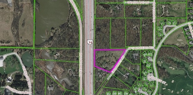
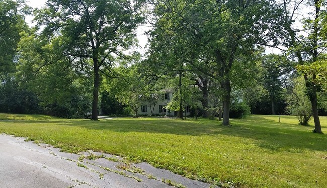
480 Saunders Rd, Lake Forest, IL 60045

NEARBY LISTINGS FOR SALE OR LEASE
-
-
-
-
-
-
-
No Photo
-
View all Lake Forest listings for sale on LoopNet.com
Property Detail
480 Saunders Rd
15-01-300-032
PT NE SW;COM ON WLN AT PNT 33S OF NWCOR,E TO CLN SAUNDERS R D,SW ALG CLN 601.65,N69D33W TO WLN,N TO POB SECTION 01 TO WNSHIP 43 RANGE 11
Residentialacreage
Lake
X
Illinois
17097C0257K
6.07 AC
2023
Central North
2024
Chicago
866200
Chicago-Naperville-Elgin, IL-IN-WI
DEMOGRAPHICS near 480 Saunders Rd
1 Mile
3 Mile
5 Mile
2024 Total Population
1,493
23,348
127,552
2029 Population
1,492
23,345
127,033
Pop Growth 2024-2029
(0.07%)
(0.01%)
(0.41%)
Average Age
49
45
41
2024 Total Households
576
8,416
47,068
HH Growth 2024-2029
(0.17%)
+ 0.01%
(0.41%)
Median Household Inc
$210,231
$170,448
$135,434
Avg Household Size
2.50
2.60
2.60
2024 Avg HH Vehicles
2.00
2.00
2.00
Median Home Value
$829,645
$734,879
$542,640
Median Year Built
1992
1986
1982
Nearby Places
Map Layers
Map Styles
 Street
 Aerial
- Restaurants
- Banks
- Shops
- Fitness
- Groceries
PUBLIC TRANSPORTATION
COMMUTER RAIL
Lake Forest Station (Md-North) (Milwaukee District North Line - Northeast Illinois Regional Commuter Railroad (Metra))
DRIVE
WALK
Distance
Lake Forest Station (Md-North) (Milwaukee District North Line - Northeast Illinois Regional Commuter Railroad (Metra))
8 min
3.5 mi
Lake Forest Station (Up-North) (Union Pacific North Line - Northeast Illinois Regional Commuter Railroad (Metra))
DRIVE
WALK
Distance
Lake Forest Station (Up-North) (Union Pacific North Line - Northeast Illinois Regional Commuter Railroad (Metra))
10 min
4.3 mi
AIRPORT
Chicago O'Hare International
DRIVE
WALK
Distance
Chicago O'Hare International
31 min
22.0 mi
Freight Ports
Port Milwaukee
DRIVE
WALK
Distance
Port Milwaukee
68 min
57.0 mi
Nearby Properties
Address
Land Use
TOTAL SIZE
Lot Size
Zoning
Address
Land Use
TOTAL SIZE
Lot Size
Zoning
145.94 AC
Address
Land Use
TOTAL SIZE
Lot Size
Zoning
12.96 AC
Address
Land Use
TOTAL SIZE
Lot Size
Zoning
19.93 AC
Address
Land Use
TOTAL SIZE
Lot Size
Zoning
23.12 AC
Address
Land Use
TOTAL SIZE
Lot Size
Zoning
Address
Land Use
TOTAL SIZE
Lot Size
Zoning
Address
Land Use
TOTAL SIZE
Lot Size
Zoning
28.14 AC
Address
Land Use
TOTAL SIZE
Lot Size
Zoning
51,750 SF
48.98 AC
Address
Land Use
TOTAL SIZE
Lot Size
Zoning
17.35 AC
Address
Land Use
TOTAL SIZE
Lot Size
Zoning
315,160 SF
15.50 AC
Address
Land Use
TOTAL SIZE
Lot Size
Zoning
Address
Land Use
TOTAL SIZE
Lot Size
Zoning
7.98 AC
Address
Land Use
TOTAL SIZE
Lot Size
Zoning
Address
Land Use
TOTAL SIZE
Lot Size
Zoning
10.24 AC
Address
Land Use
TOTAL SIZE
Lot Size
Zoning
Address
Land Use
TOTAL SIZE
Lot Size
Zoning
25.66 AC
Address
Land Use
TOTAL SIZE
Lot Size
Zoning
16.20 AC
Address
Land Use
TOTAL SIZE
Lot Size
Zoning
698,127 SF
7.94 AC
Address
Land Use
TOTAL SIZE
Lot Size
Zoning
Address
Land Use
TOTAL SIZE
Lot Size
Zoning
10.68 AC
Address
Land Use
TOTAL SIZE
Lot Size
Zoning
10.80 AC
Address
Land Use
TOTAL SIZE
Lot Size
Zoning
13.88 AC
Address
Land Use
TOTAL SIZE
Lot Size
Zoning
15.47 AC
Address
Land Use
TOTAL SIZE
Lot Size
Zoning
16.06 AC
Address
Land Use
TOTAL SIZE
Lot Size
Zoning
7.99 AC
Address
Land Use
TOTAL SIZE
Lot Size
Zoning
15.23 AC
Address
Land Use
TOTAL SIZE
Lot Size
Zoning
15.18 AC
Address
Land Use
TOTAL SIZE
Lot Size
Zoning
20.03 AC
Address
Land Use
TOTAL SIZE
Lot Size
Zoning
3.57 AC
Address
Land Use
TOTAL SIZE
Lot Size
Zoning
74,599 SF
9.16 AC
The World's #1 Commercial Real Estate Marketplace
Connect with us
© 2025 CoStar Group
The information above has been obtained from sources believed reliable. While we do not doubt its accuracy we have not verified it and make no guarantee, warranty or representation about it. It is your responsibility to independently confirm its accuracy and completeness. Any projections, opinions, assumptions, or estimates used are for example only and do not represent the current or future performance of the property. The value of this transaction to you depends on tax and other factors which should be evaluated by your tax, financial, and legal advisors. You and your advisors should conduct a careful, independent investigation of the property to determine to your satisfaction the suitability of the property for your needs.