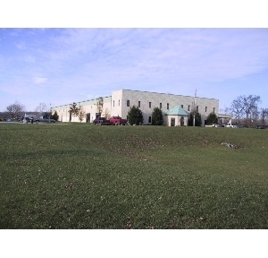
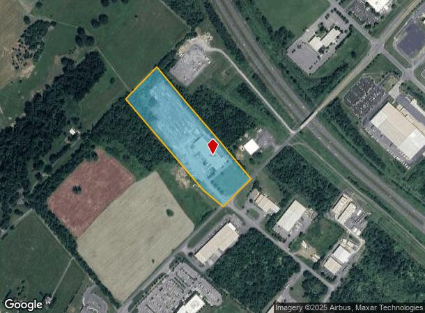
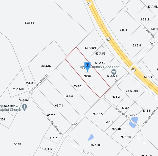
Property Record
480 Shady Elm Rd, Winchester, VA 22602
NEARBY LISTINGS FOR SALE OR LEASE
Property Detail
480 Shady Elm Rd
637-1
1
Multipleuses
8.77 ACRES
X
Frederick
51069C0214E
Virginia
2025
8.77 AC
2025
Frederick County VA
050900
Washington, DC
34,201 SF
Winchester, VA-WV
DEMOGRAPHICS near 480 Shady Elm Rd
1 Mile
3 Mile
5 Mile
2024 Total Population
891
24,734
58,809
2029 Population
976
26,501
62,367
Pop Growth 2024-2029
+ 9.54%
+ 7.14%
+ 6.05%
Average Age
46
40
40
2024 Total Households
383
9,722
22,586
HH Growth 2024-2029
+ 9.66%
+ 6.87%
+ 5.76%
Median Household Inc
$76,724
$73,244
$76,911
Avg Household Size
2.30
2.50
2.50
2024 Avg HH Vehicles
2.00
2.00
2.00
Median Home Value
$398,412
$295,537
$326,476
Median Year Built
1992
1988
1985
Nearby Places
Map Layers
Map Styles
 Street
 Aerial
- Restaurants
- Banks
- Shops
- Fitness
- Groceries
Nearby Properties
Address
Land Use
TOTAL SIZE
Lot Size
Zoning
Address
Land Use
TOTAL SIZE
Lot Size
Zoning
375,081 SF
74.09 AC
M2
Address
Land Use
TOTAL SIZE
Lot Size
Zoning
30,054 SF
62.32 AC
M2
Address
Land Use
TOTAL SIZE
Lot Size
Zoning
411,597 SF
32.20 AC
M1
Address
Land Use
TOTAL SIZE
Lot Size
Zoning
15.24 AC
RP
Address
Land Use
TOTAL SIZE
Lot Size
Zoning
254,560 SF
42.88 AC
M1
Address
Land Use
TOTAL SIZE
Lot Size
Zoning
351,500 SF
28.38 AC
M1
Address
Land Use
TOTAL SIZE
Lot Size
Zoning
231,756 SF
23.66 AC
CM1
Address
Land Use
TOTAL SIZE
Lot Size
Zoning
151,711 SF
16.25 AC
CM1
Address
Land Use
TOTAL SIZE
Lot Size
Zoning
181,832 SF
17.96 AC
CM1
Address
Land Use
TOTAL SIZE
Lot Size
Zoning
2,310 SF
17.28 AC
RP
Address
Land Use
TOTAL SIZE
Lot Size
Zoning
252,000 SF
24.87 AC
M1
Address
Land Use
TOTAL SIZE
Lot Size
Zoning
239,570 SF
17 AC
M1
Address
Land Use
TOTAL SIZE
Lot Size
Zoning
440,999 SF
55.46 AC
M1
Address
Land Use
TOTAL SIZE
Lot Size
Zoning
87,000 SF
16.30 AC
EIP
Address
Land Use
TOTAL SIZE
Lot Size
Zoning
71,569 SF
37.35 AC
RA
Address
Land Use
TOTAL SIZE
Lot Size
Zoning
204,600 SF
14.38 AC
M1
Address
Land Use
TOTAL SIZE
Lot Size
Zoning
3,332 SF
6.86 AC
HR
Address
Land Use
TOTAL SIZE
Lot Size
Zoning
169,744 SF
9.68 AC
HR
Address
Land Use
TOTAL SIZE
Lot Size
Zoning
139,911 SF
14.46 AC
CM1
Address
Land Use
TOTAL SIZE
Lot Size
Zoning
107,923 SF
23.65 AC
RP
Address
Land Use
TOTAL SIZE
Lot Size
Zoning
75,257 SF
18.29 AC
RP
Address
Land Use
TOTAL SIZE
Lot Size
Zoning
16,948 SF
5.44 AC
HR
Address
Land Use
TOTAL SIZE
Lot Size
Zoning
59,003 SF
8.50 AC
B2
Address
Land Use
TOTAL SIZE
Lot Size
Zoning
41,733 SF
4.68 AC
B2
Address
Land Use
TOTAL SIZE
Lot Size
Zoning
114,900 SF
10.72 AC
CM1
Address
Land Use
TOTAL SIZE
Lot Size
Zoning
300,515 SF
20.73 AC
M1
Address
Land Use
TOTAL SIZE
Lot Size
Zoning
105,340 SF
18.45 AC
M1
Address
Land Use
TOTAL SIZE
Lot Size
Zoning
126,580 SF
9.27 AC
B3
Address
Land Use
TOTAL SIZE
Lot Size
Zoning
8,649 SF
5.50 AC
HR
Address
Land Use
TOTAL SIZE
Lot Size
Zoning
62,210 SF
8 AC
CM1
The World's #1 Commercial Real Estate Marketplace
Connect with us
© 2026 CoStar Group
The information above has been obtained from sources believed reliable. While we do not doubt its accuracy we have not verified it and make no guarantee, warranty or representation about it. It is your responsibility to independently confirm its accuracy and completeness. Any projections, opinions, assumptions, or estimates used are for example only and do not represent the current or future performance of the property. The value of this transaction to you depends on tax and other factors which should be evaluated by your tax, financial, and legal advisors. You and your advisors should conduct a careful, independent investigation of the property to determine to your satisfaction the suitability of the property for your needs.