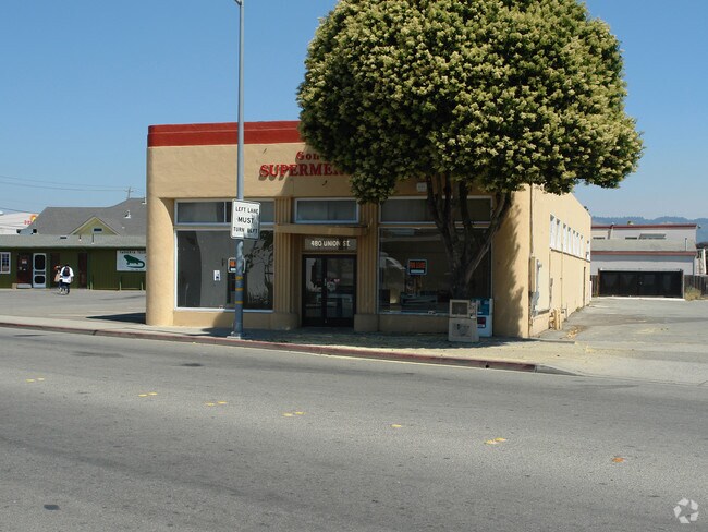
Property Record
480 Union St, Watsonville, CA 95076


Save to a Folder
{{folder.Name}}
{{folder.ListingIds.length}} Properties
{{folder.ListingIds.length}} Property
Create a New Folder
Property Detail
480 Union St
017-661-28-000
Santa Cruz
Religious
California
B and X Area of moderate flood hazard, usually the area between the limits of the 100-year and 500-year floods.
0.32 AC
2024
Watsonville
2025
Santa Cruz/Watsonville
110301
Santa Cruz-Watsonville, CA
4,860 SF
NEARBY LISTINGS FOR SALE OR LEASE
DEMOGRAPHICS near 480 Union St
1 mile
3 mile
5 mile
2025 Total Population
25,754
61,896
74,790
2030 Population
24,887
59,987
72,382
Pop Growth 2025-2030
(3.37%)
(3.08%)
(3.22%)
Average Age
35
36
37
2025 Total Households
6,672
16,311
19,780
HH Growth 2025-2030
(3.94%)
(3.59%)
(3.74%)
Median Household Inc
$73,788
$77,826
$80,695
Avg Household Size
3.60
3.60
3.50
2025 Avg HH Vehicles
2.00
2.00
2.00
Median Home Value
$706,662
$716,594
$742,509
Median Year Built
1963
1973
1973
Nearby Places
Map Layers
Map Styles
 Street
 Aerial
Layers
 Traffic
 Biking
Places
Listings with unknown addresses are not visible on the map
- Restaurants
- Banks
- Shops
- Fitness
- Groceries
PUBLIC TRANSPORTATION
AIRPORT
Monterey Regional
Drive
Walk
Distance
Monterey Regional
37 min
27.9 mi
Norman Y Mineta San Jose International
Drive
Walk
Distance
Norman Y Mineta San Jose International
63 min
47.2 mi
Freight Ports
Port of Redwood City
Drive
Walk
Distance
Port of Redwood City
82 min
63.0 mi
SALE & LEASE HISTORY
LISTING DATE
SALE/LEASE

Jun 08, 2019
For Sale
Jul 24, 2017
For Sale
Nearby Properties
Address
Land Use
TOTAL SIZE
Lot Size
Zoning
Address
Land Use
TOTAL SIZE
Lot Size
Zoning
3,767 SF
6.90 AC
RM-2-R
Address
Land Use
TOTAL SIZE
Lot Size
Zoning
163,824 SF
13.98 AC
Address
Land Use
TOTAL SIZE
Lot Size
Zoning
155,402 SF
11.53 AC
Address
Land Use
TOTAL SIZE
Lot Size
Zoning
193,645 SF
25.70 AC
Address
Land Use
TOTAL SIZE
Lot Size
Zoning
60,392 SF
4.07 AC
RM-4
Address
Land Use
TOTAL SIZE
Lot Size
Zoning
77,449 SF
14.38 AC
R-1-6
Address
Land Use
TOTAL SIZE
Lot Size
Zoning
64,650 SF
6.04 AC
Address
Land Use
TOTAL SIZE
Lot Size
Zoning
146,574 SF
9.97 AC
Address
Land Use
TOTAL SIZE
Lot Size
Zoning
Address
Land Use
TOTAL SIZE
Lot Size
Zoning
94,674 SF
3.38 AC
Address
Land Use
TOTAL SIZE
Lot Size
Zoning
2.34 AC
Address
Land Use
TOTAL SIZE
Lot Size
Zoning
5,963 SF
7.89 AC
Address
Land Use
TOTAL SIZE
Lot Size
Zoning
373,950 SF
16.47 AC
Address
Land Use
TOTAL SIZE
Lot Size
Zoning
8.45 AC
Address
Land Use
TOTAL SIZE
Lot Size
Zoning
8.64 AC
Address
Land Use
TOTAL SIZE
Lot Size
Zoning
7.94 AC
Address
Land Use
TOTAL SIZE
Lot Size
Zoning
59,897 SF
1.54 AC
Address
Land Use
TOTAL SIZE
Lot Size
Zoning
4.59 AC
CA
Address
Land Use
TOTAL SIZE
Lot Size
Zoning
41,700 SF
3 AC
PA
Address
Land Use
TOTAL SIZE
Lot Size
Zoning
58,495 SF
1.77 AC
Address
Land Use
TOTAL SIZE
Lot Size
Zoning
10.47 AC
CAW
Address
Land Use
TOTAL SIZE
Lot Size
Zoning
Address
Land Use
TOTAL SIZE
Lot Size
Zoning
40,585 SF
2.40 AC
R-1-6
Address
Land Use
TOTAL SIZE
Lot Size
Zoning
14.98 AC
PF
Address
Land Use
TOTAL SIZE
Lot Size
Zoning
53,672 SF
5.14 AC
Address
Land Use
TOTAL SIZE
Lot Size
Zoning
45,000 SF
1.56 AC
Address
Land Use
TOTAL SIZE
Lot Size
Zoning
64,472 SF
3.27 AC
Address
Land Use
TOTAL SIZE
Lot Size
Zoning
7.02 AC
Address
Land Use
TOTAL SIZE
Lot Size
Zoning
65,782 SF
3.60 AC
Address
Land Use
TOTAL SIZE
Lot Size
Zoning
75,884 SF
2.03 AC
The World's #1 Commercial Real Estate Marketplace
Connect with us
© 2026 CoStar Group
The information above has been obtained from sources believed reliable. While we do not doubt its accuracy we have not verified it and make no guarantee, warranty or representation about it. It is your responsibility to independently confirm its accuracy and completeness. Any projections, opinions, assumptions, or estimates used are for example only and do not represent the current or future performance of the property. The value of this transaction to you depends on tax and other factors which should be evaluated by your tax, financial, and legal advisors. You and your advisors should conduct a careful, independent investigation of the property to determine to your satisfaction the suitability of the property for your needs.