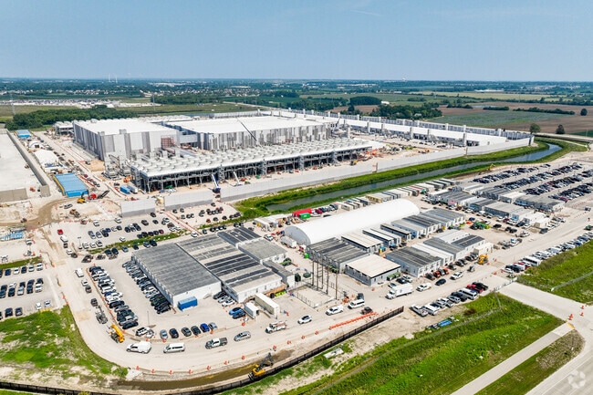
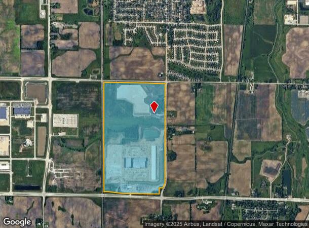
Property Record
4800 90Th St, Mt Pleasant, WI 53403
NEARBY LISTINGS FOR SALE OR LEASE
Property Detail
4800 90Th St
Racine, WI
PT NE1/4 & NW1/4 & SW1/4 & SE1/4CSM 3554 DOC#2654701LOT 1 FROM 151032233001000,151032233001001, 151032233002000, 151032233003
151-032233004010
Racine
Commercialnec
Wisconsin
2024
318.64 AC
2024
Racine East
000700
Milwaukee/Madison
DEMOGRAPHICS near 4800 90Th St
1 Mile
3 Mile
5 Mile
2024 Total Population
2,299
13,329
63,389
2029 Population
2,287
13,256
62,911
Pop Growth 2024-2029
(0.52%)
(0.55%)
(0.75%)
Average Age
39
42
42
2024 Total Households
837
4,736
26,103
HH Growth 2024-2029
(0.60%)
(0.38%)
(0.75%)
Median Household Inc
$100,507
$74,954
$66,921
Avg Household Size
2.70
2.40
2.30
2024 Avg HH Vehicles
2.00
2.00
2.00
Median Home Value
$247,474
$234,689
$208,785
Median Year Built
1982
1976
1974
Nearby Places
Map Layers
Map Styles
 Street
 Aerial
- Restaurants
- Banks
- Shops
- Fitness
- Groceries
PUBLIC TRANSPORTATION
COMMUTER RAIL
Sturtevant Amtrak Station (Hiawatha Service - Amtrak)
DRIVE
WALK
Distance
Sturtevant Amtrak Station (Hiawatha Service - Amtrak)
10 min
4.1 mi
AIRPORT
General Mitchell International
DRIVE
WALK
Distance
General Mitchell International
33 min
24.7 mi
Freight Ports
Port Milwaukee
DRIVE
WALK
Distance
Port Milwaukee
37 min
28.6 mi
Nearby Properties
Address
Land Use
TOTAL SIZE
Lot Size
Zoning
Address
Land Use
TOTAL SIZE
Lot Size
Zoning
861.42 AC
Address
Land Use
TOTAL SIZE
Lot Size
Zoning
22.34 AC
Address
Land Use
TOTAL SIZE
Lot Size
Zoning
241.29 AC
Address
Land Use
TOTAL SIZE
Lot Size
Zoning
241.29 AC
Address
Land Use
TOTAL SIZE
Lot Size
Zoning
773 SF
21.36 AC
Address
Land Use
TOTAL SIZE
Lot Size
Zoning
Address
Land Use
TOTAL SIZE
Lot Size
Zoning
9.40 AC
B-3
Address
Land Use
TOTAL SIZE
Lot Size
Zoning
47.01 AC
M-1
Address
Land Use
TOTAL SIZE
Lot Size
Zoning
32.55 AC
Address
Land Use
TOTAL SIZE
Lot Size
Zoning
57.80 AC
M1
Address
Land Use
TOTAL SIZE
Lot Size
Zoning
26.79 AC
Address
Land Use
TOTAL SIZE
Lot Size
Zoning
Address
Land Use
TOTAL SIZE
Lot Size
Zoning
Address
Land Use
TOTAL SIZE
Lot Size
Zoning
23.21 AC
Address
Land Use
TOTAL SIZE
Lot Size
Zoning
140.07 AC
Address
Land Use
TOTAL SIZE
Lot Size
Zoning
9.31 AC
Address
Land Use
TOTAL SIZE
Lot Size
Zoning
30.45 AC
002
Address
Land Use
TOTAL SIZE
Lot Size
Zoning
20.61 AC
Address
Land Use
TOTAL SIZE
Lot Size
Zoning
19.29 AC
002
Address
Land Use
TOTAL SIZE
Lot Size
Zoning
22.98 AC
M-1
Address
Land Use
TOTAL SIZE
Lot Size
Zoning
32.99 AC
002
Address
Land Use
TOTAL SIZE
Lot Size
Zoning
16.97 AC
Address
Land Use
TOTAL SIZE
Lot Size
Zoning
19.77 AC
B-3
Address
Land Use
TOTAL SIZE
Lot Size
Zoning
6.77 AC
PUL
Address
Land Use
TOTAL SIZE
Lot Size
Zoning
81.82 AC
Address
Land Use
TOTAL SIZE
Lot Size
Zoning
16.91 AC
Address
Land Use
TOTAL SIZE
Lot Size
Zoning
77.26 AC
Address
Land Use
TOTAL SIZE
Lot Size
Zoning
76.64 AC
Address
Land Use
TOTAL SIZE
Lot Size
Zoning
15.81 AC
The World's #1 Commercial Real Estate Marketplace
Connect with us
© 2025 CoStar Group
The information above has been obtained from sources believed reliable. While we do not doubt its accuracy we have not verified it and make no guarantee, warranty or representation about it. It is your responsibility to independently confirm its accuracy and completeness. Any projections, opinions, assumptions, or estimates used are for example only and do not represent the current or future performance of the property. The value of this transaction to you depends on tax and other factors which should be evaluated by your tax, financial, and legal advisors. You and your advisors should conduct a careful, independent investigation of the property to determine to your satisfaction the suitability of the property for your needs.