Property Record
4750 E 131St St, Garfield Heights, OH 44105
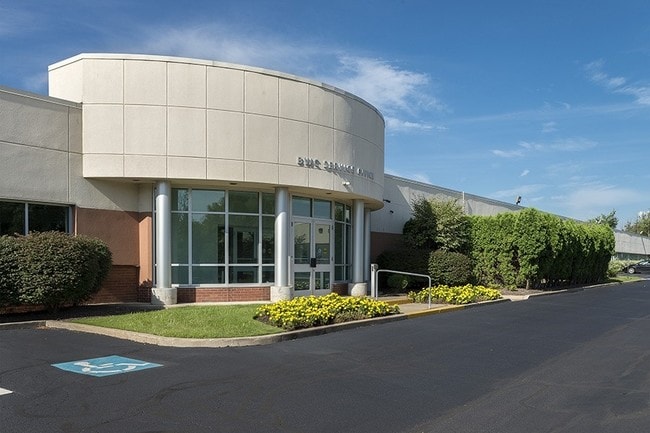


This Property Is For Sale
Current Lease Availabilities
NEARBY LISTINGS FOR SALE OR LEASE
Property Detail
4750 E 131St St
Cleveland
Add
Cleveland-Elyria, OH
PCL B VOL 365 PG 08 FF 575.90 D 707.11 6.8704AC OL 485 ADDITIONAL PARCELS 54606001 THRU 009, 026 AND 028 2012S/R
546-05-008
Cuyahoga
Miscellaneous
Ohio
0
485
2024
6.87 AC
198200
South
79,680 SF
DEMOGRAPHICS near 4750 E 131St St
1 Mile
3 Mile
5 Mile
2024 Total Population
11,670
112,067
227,500
2029 Population
11,423
109,266
221,977
Pop Growth 2024-2029
(2.12%)
(2.50%)
(2.43%)
Average Age
42
41
41
2024 Total Households
4,733
47,549
99,702
HH Growth 2024-2029
(2.28%)
(2.70%)
(2.62%)
Median Household Inc
$41,862
$41,196
$46,079
Avg Household Size
2.30
2.30
2.20
2024 Avg HH Vehicles
1.00
1.00
1.00
Median Home Value
$68,665
$68,998
$98,370
Median Year Built
1949
1949
1950
Nearby Places
Map Layers
Map Styles
 Street
 Aerial
- Restaurants
- Banks
- Shops
- Fitness
- Groceries
PUBLIC TRANSPORTATION
COMMUTER RAIL
Rockside (National Park Scenic Railway - Cuyahoga Valley Scenic Railroad)
DRIVE
WALK
Distance
Rockside (National Park Scenic Railway - Cuyahoga Valley Scenic Railroad)
12 min
5.2 mi
Canal Exploration Center (National Park Scenic Railway - Cuyahoga Valley Scenic Railroad)
DRIVE
WALK
Distance
Canal Exploration Center (National Park Scenic Railway - Cuyahoga Valley Scenic Railroad)
15 min
5.9 mi
AIRPORT
Cleveland-Hopkins International
DRIVE
WALK
Distance
Cleveland-Hopkins International
27 min
16.6 mi
Freight Ports
Port of Toledo
DRIVE
WALK
Distance
Port of Toledo
141 min
117.5 mi
Nearby Properties
Address
Land Use
TOTAL SIZE
Lot Size
Zoning
Address
Land Use
TOTAL SIZE
Lot Size
Zoning
162,711 SF
192.04 AC
IG
Address
Land Use
TOTAL SIZE
Lot Size
Zoning
230,820 SF
41.47 AC
UI
Address
Land Use
TOTAL SIZE
Lot Size
Zoning
186,275 SF
17.80 AC
U-8
Address
Land Use
TOTAL SIZE
Lot Size
Zoning
279,200 SF
37.19 AC
IG
Address
Land Use
TOTAL SIZE
Lot Size
Zoning
129,112 SF
24.11 AC
U-8
Address
Land Use
TOTAL SIZE
Lot Size
Zoning
289,009 SF
25.27 AC
I/O
Address
Land Use
TOTAL SIZE
Lot Size
Zoning
248,498 SF
14.31 AC
U-8
Address
Land Use
TOTAL SIZE
Lot Size
Zoning
227,141 SF
23.76 AC
U-4
Address
Land Use
TOTAL SIZE
Lot Size
Zoning
205,724 SF
6.54 AC
U-8
Address
Land Use
TOTAL SIZE
Lot Size
Zoning
32,400 SF
52.29 AC
U-4
Address
Land Use
TOTAL SIZE
Lot Size
Zoning
189,156 SF
24.49 AC
IG
Address
Land Use
TOTAL SIZE
Lot Size
Zoning
221,406 SF
12.05 AC
2F
Address
Land Use
TOTAL SIZE
Lot Size
Zoning
105,215 SF
5.42 AC
PF
Address
Land Use
TOTAL SIZE
Lot Size
Zoning
155,896 SF
16.38 AC
Address
Land Use
TOTAL SIZE
Lot Size
Zoning
277,049 SF
24.15 AC
2F
Address
Land Use
TOTAL SIZE
Lot Size
Zoning
347,218 SF
0.23 AC
O/I
Address
Land Use
TOTAL SIZE
Lot Size
Zoning
65,108 SF
24.93 AC
I/O
Address
Land Use
TOTAL SIZE
Lot Size
Zoning
191,322 SF
23.60 AC
1F
Address
Land Use
TOTAL SIZE
Lot Size
Zoning
133,913 SF
18.36 AC
U-11B
Address
Land Use
TOTAL SIZE
Lot Size
Zoning
15,154 SF
9.24 AC
SI
Address
Land Use
TOTAL SIZE
Lot Size
Zoning
350,592 SF
25.29 AC
O/I
Address
Land Use
TOTAL SIZE
Lot Size
Zoning
336,730 SF
38.51 AC
U-11A
Address
Land Use
TOTAL SIZE
Lot Size
Zoning
4,160 SF
1.84 AC
U-6
Address
Land Use
TOTAL SIZE
Lot Size
Zoning
718,431 SF
18.75 AC
O/I
Address
Land Use
TOTAL SIZE
Lot Size
Zoning
235,921 SF
12.45 AC
SC
Address
Land Use
TOTAL SIZE
Lot Size
Zoning
173,110 SF
6.38 AC
U-8
Address
Land Use
TOTAL SIZE
Lot Size
Zoning
106,698 SF
3.27 AC
CM
Address
Land Use
TOTAL SIZE
Lot Size
Zoning
64,903 SF
3.48 AC
2F
Address
Land Use
TOTAL SIZE
Lot Size
Zoning
64,399 SF
1.82 AC
U-8
Address
Land Use
TOTAL SIZE
Lot Size
Zoning
47,675 SF
111.88 AC
2F
The World's #1 Commercial Real Estate Marketplace
Connect with us
© 2025 CoStar Group
The information above has been obtained from sources believed reliable. While we do not doubt its accuracy we have not verified it and make no guarantee, warranty or representation about it. It is your responsibility to independently confirm its accuracy and completeness. Any projections, opinions, assumptions, or estimates used are for example only and do not represent the current or future performance of the property. The value of this transaction to you depends on tax and other factors which should be evaluated by your tax, financial, and legal advisors. You and your advisors should conduct a careful, independent investigation of the property to determine to your satisfaction the suitability of the property for your needs.