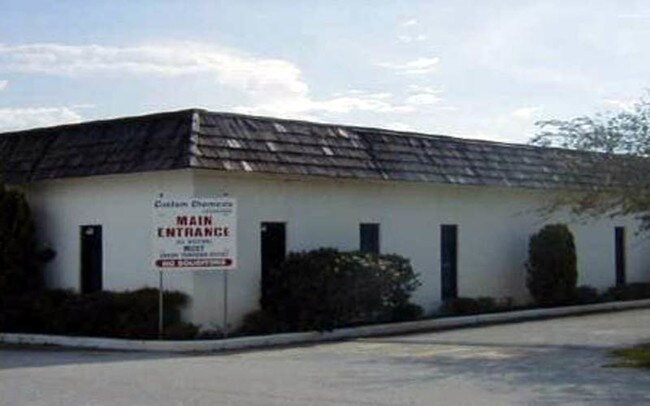
Property Record
4800 Highway 60 E, Mulberry, FL 33860

Property Detail
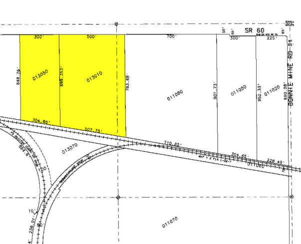
4800 Highway 60 E
24-30-08-000000-013020
W 890 FT OF E 2948 FT OF N1/4 N OF RR & S OF HWY INCLUDES OIL GAS & MINERAL INTEREST IN THE WEST 300 FT THEREOF & W 300 FT OF E 2058 FT OF N1/4 N OF RR & S OF HWY BEING LOTS 19 THRU 21 OF UNREC RIDGEWOOD ESTATES & BEG 79.85 FT S & 2958 FT W OF NE COR
Lightindustrial
POLK
C4
Florida
B and X Area of moderate flood hazard, usually the area between the limits of the 100-year and 500-year floods.
31-33
2024
20.09 AC
2025
Polk County
014905
Tampa/St Petersburg
172,931 SF
Lakeland-Winter Haven, FL
NEARBY LISTINGS FOR SALE OR LEASE
DEMOGRAPHICS near 4800 Highway 60 E
1 mile
3 mile
5 mile
2025 Total Population
8
4,079
48,395
2030 Population
9
4,687
54,899
Pop Growth 2025-2030
+ 12.50%
+ 14.91%
+ 13.44%
Average Age
36
40
40
2025 Total Households
3
1,538
17,789
HH Growth 2025-2030
0.00%
+ 15.15%
+ 13.74%
Median Household Inc
$300,000
$65,061
$98,711
Avg Household Size
3.00
2.60
2.70
2025 Avg HH Vehicles
2.00
2.00
2.00
Median Home Value
$499,999
$213,679
$353,494
Median Year Built
2010
2000
1998
Nearby Places
Map Layers
Map Styles
 Street
 Aerial
Layers
 Traffic
 Biking
Places
Listings with unknown addresses are not visible on the map
- Restaurants
- Banks
- Shops
- Fitness
- Groceries
Nearby Properties
Address
Land Use
TOTAL SIZE
Lot Size
Zoning
Address
Land Use
TOTAL SIZE
Lot Size
Zoning
322,938 SF
25.94 AC
Address
Land Use
TOTAL SIZE
Lot Size
Zoning
166,313 SF
63.97 AC
Address
Land Use
TOTAL SIZE
Lot Size
Zoning
174,251 SF
26.66 AC
Address
Land Use
TOTAL SIZE
Lot Size
Zoning
401,870 SF
545.26 AC
Address
Land Use
TOTAL SIZE
Lot Size
Zoning
116,961 SF
5.01 AC
I1
Address
Land Use
TOTAL SIZE
Lot Size
Zoning
103,698 SF
10.86 AC
GI
Address
Land Use
TOTAL SIZE
Lot Size
Zoning
105,863 SF
33.77 AC
Address
Land Use
TOTAL SIZE
Lot Size
Zoning
56,689 SF
9.30 AC
Address
Land Use
TOTAL SIZE
Lot Size
Zoning
42,368 SF
13.63 AC
C4
Address
Land Use
TOTAL SIZE
Lot Size
Zoning
41,093 SF
1.58 AC
C1
Address
Land Use
TOTAL SIZE
Lot Size
Zoning
33,736 SF
18.34 AC
RC
Address
Land Use
TOTAL SIZE
Lot Size
Zoning
93,186 SF
2.67 AC
I1
Address
Land Use
TOTAL SIZE
Lot Size
Zoning
12,452 SF
2.49 AC
C1
Address
Land Use
TOTAL SIZE
Lot Size
Zoning
28,852 SF
5.19 AC
C2
Address
Land Use
TOTAL SIZE
Lot Size
Zoning
29,902 SF
2.93 AC
Address
Land Use
TOTAL SIZE
Lot Size
Zoning
23,946 SF
11.18 AC
C4
Address
Land Use
TOTAL SIZE
Lot Size
Zoning
581.94 AC
Address
Land Use
TOTAL SIZE
Lot Size
Zoning
37,474 SF
13.22 AC
Address
Land Use
TOTAL SIZE
Lot Size
Zoning
15,500 SF
2.25 AC
Address
Land Use
TOTAL SIZE
Lot Size
Zoning
16,944 SF
11.66 AC
Address
Land Use
TOTAL SIZE
Lot Size
Zoning
13,325 SF
9.94 AC
RC
Address
Land Use
TOTAL SIZE
Lot Size
Zoning
33,303 SF
318.36 AC
Address
Land Use
TOTAL SIZE
Lot Size
Zoning
25,625 SF
2.97 AC
C3
Address
Land Use
TOTAL SIZE
Lot Size
Zoning
23,227 SF
4.44 AC
Address
Land Use
TOTAL SIZE
Lot Size
Zoning
10,629 SF
1.57 AC
XX
Address
Land Use
TOTAL SIZE
Lot Size
Zoning
66,755 SF
3.17 AC
I1
Address
Land Use
TOTAL SIZE
Lot Size
Zoning
8,640 SF
2.58 AC
Address
Land Use
TOTAL SIZE
Lot Size
Zoning
23,833 SF
6.12 AC
R2
Address
Land Use
TOTAL SIZE
Lot Size
Zoning
7,400 SF
5 AC
RC
The World's #1 Commercial Real Estate Marketplace
Connect with us
© 2026 CoStar Group
The information above has been obtained from sources believed reliable. While we do not doubt its accuracy we have not verified it and make no guarantee, warranty or representation about it. It is your responsibility to independently confirm its accuracy and completeness. Any projections, opinions, assumptions, or estimates used are for example only and do not represent the current or future performance of the property. The value of this transaction to you depends on tax and other factors which should be evaluated by your tax, financial, and legal advisors. You and your advisors should conduct a careful, independent investigation of the property to determine to your satisfaction the suitability of the property for your needs.