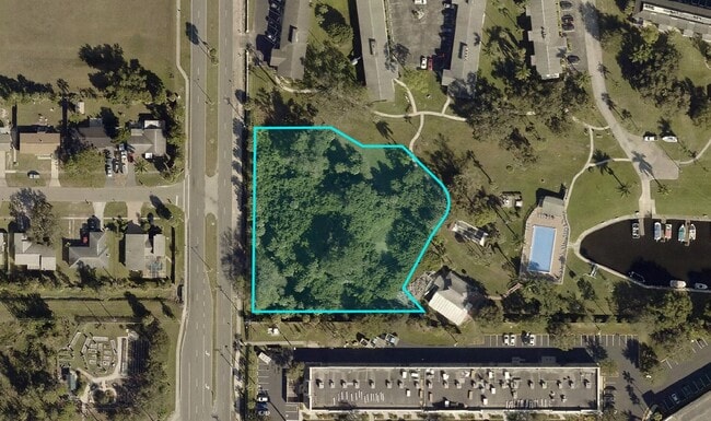
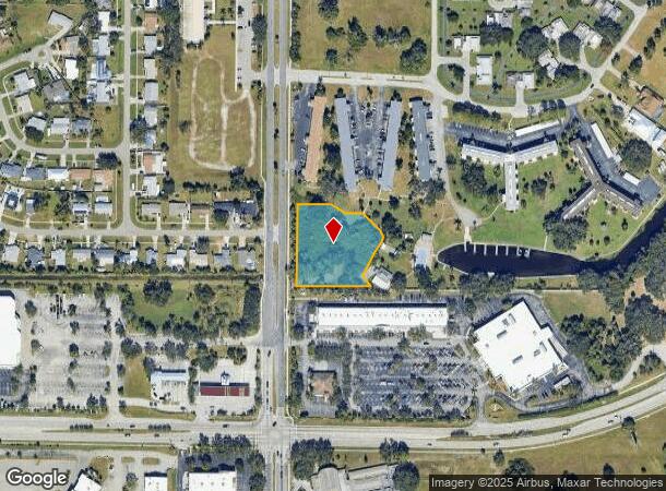
Property Record
4800 Orange Grove Blvd, North Fort Myers, FL 33903
This Property Is For Sale
NEARBY LISTINGS FOR SALE OR LEASE
Property Detail
4800 Orange Grove Blvd
Cape Coral-Fort Myers, FL
Pangola
09-44-24-00-01002.0000
COMM SW COR OF SE1/4 E50 N 472TOPOB THEN N 260 E110 SELY53 E56 SELY77 TO CURVE
Residentialacreage
Lee
AE
Florida
12071C0268G
1.37 AC
2024
Cape Coral
2025
Southwest Florida
020600
DEMOGRAPHICS near 4800 Orange Grove Blvd
1 Mile
3 Mile
5 Mile
2024 Total Population
9,637
54,487
166,004
2029 Population
11,251
64,250
196,132
Pop Growth 2024-2029
+ 16.75%
+ 17.92%
+ 18.15%
Average Age
44
45
44
2024 Total Households
3,842
22,864
67,595
HH Growth 2024-2029
+ 16.24%
+ 17.64%
+ 17.72%
Median Household Inc
$66,893
$60,290
$55,773
Avg Household Size
2.40
2.30
2.40
2024 Avg HH Vehicles
2.00
2.00
2.00
Median Home Value
$282,830
$251,573
$236,888
Median Year Built
1986
1988
1988
Nearby Places
- Restaurants
- Banks
- Shops
- Fitness
- Groceries
PUBLIC TRANSPORTATION
AIRPORT
Southwest Florida International
DRIVE
WALK
Distance
Southwest Florida International
32 min
18.1 mi
Punta Gorda
DRIVE
WALK
Distance
Punta Gorda
34 min
22.7 mi
Freight Ports
Port Manatee
DRIVE
WALK
Distance
Port Manatee
114 min
94.4 mi
Nearby Properties
Address
Land Use
TOTAL SIZE
Lot Size
Zoning
Address
Land Use
TOTAL SIZE
Lot Size
Zoning
634,872 SF
43.30 AC
C1-D
Address
Land Use
TOTAL SIZE
Lot Size
Zoning
770,753 SF
5.87 AC
PUD
Address
Land Use
TOTAL SIZE
Lot Size
Zoning
214,515 SF
30.60 AC
I-1
Address
Land Use
TOTAL SIZE
Lot Size
Zoning
485,271 SF
20.05 AC
CORR
Address
Land Use
TOTAL SIZE
Lot Size
Zoning
646,502 SF
6.11 AC
PUD
Address
Land Use
TOTAL SIZE
Lot Size
Zoning
552,157 SF
4.20 AC
PUD
Address
Land Use
TOTAL SIZE
Lot Size
Zoning
347,871 SF
29.40 AC
RML
Address
Land Use
TOTAL SIZE
Lot Size
Zoning
13.60 AC
CC
Address
Land Use
TOTAL SIZE
Lot Size
Zoning
339,525 SF
38.30 AC
R1BD
Address
Land Use
TOTAL SIZE
Lot Size
Zoning
163,618 SF
1.32 AC
CIVIC
Address
Land Use
TOTAL SIZE
Lot Size
Zoning
551,003 SF
3.24 AC
PUD
Address
Land Use
TOTAL SIZE
Lot Size
Zoning
333,938 SF
35.80 AC
C-1
Address
Land Use
TOTAL SIZE
Lot Size
Zoning
294,203 SF
30.22 AC
RM16
Address
Land Use
TOTAL SIZE
Lot Size
Zoning
61,844 SF
7.31 AC
CC
Address
Land Use
TOTAL SIZE
Lot Size
Zoning
305,410 SF
1.38 AC
U-CTR
Address
Land Use
TOTAL SIZE
Lot Size
Zoning
138,476 SF
4.11 AC
CORR
Address
Land Use
TOTAL SIZE
Lot Size
Zoning
451,348 SF
21.43 AC
CPD
Address
Land Use
TOTAL SIZE
Lot Size
Zoning
139,978 SF
10.75 AC
C-1
Address
Land Use
TOTAL SIZE
Lot Size
Zoning
76,154 SF
2.88 AC
U-CTR
Address
Land Use
TOTAL SIZE
Lot Size
Zoning
142,773 SF
10.82 AC
C-1
Address
Land Use
TOTAL SIZE
Lot Size
Zoning
115,004 SF
1.91 AC
CIVIC
Address
Land Use
TOTAL SIZE
Lot Size
Zoning
124,182 SF
13.30 AC
CORR
Address
Land Use
TOTAL SIZE
Lot Size
Zoning
93,758 SF
1.72 AC
CIVIC
Address
Land Use
TOTAL SIZE
Lot Size
Zoning
124,101 SF
11.60 AC
C-1
Address
Land Use
TOTAL SIZE
Lot Size
Zoning
182,503 SF
1.34 AC
CIVIC
Address
Land Use
TOTAL SIZE
Lot Size
Zoning
151,620 SF
19.97 AC
RM-2
Address
Land Use
TOTAL SIZE
Lot Size
Zoning
76,042 SF
7.50 AC
CORR
Address
Land Use
TOTAL SIZE
Lot Size
Zoning
82,478 SF
15.46 AC
CORR
Address
Land Use
TOTAL SIZE
Lot Size
Zoning
227,527 SF
0.95 AC
CIVIC
Address
Land Use
TOTAL SIZE
Lot Size
Zoning
3,585 SF
2.16 AC
U-CTR
The World's #1 Commercial Real Estate Marketplace
Connect with us
© 2025 CoStar Group
The information above has been obtained from sources believed reliable. While we do not doubt its accuracy we have not verified it and make no guarantee, warranty or representation about it. It is your responsibility to independently confirm its accuracy and completeness. Any projections, opinions, assumptions, or estimates used are for example only and do not represent the current or future performance of the property. The value of this transaction to you depends on tax and other factors which should be evaluated by your tax, financial, and legal advisors. You and your advisors should conduct a careful, independent investigation of the property to determine to your satisfaction the suitability of the property for your needs.