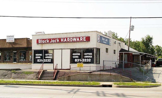
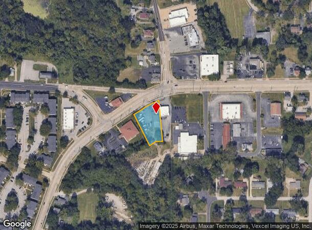
Property Record
4800 Parker Rd, Florissant, MO 63033
NEARBY LISTINGS FOR SALE OR LEASE
Property Detail
4800 Parker Rd
08G-52-0905
Us Surv 2962
Storebuilding
SUR 2962 TWN 47 R 7 LOC S SIDE OLD HALLS FERRY RD AT PARKER RD 01 19 88
X
St. Louis
29183C0325G
Missouri
2024
0.65 AC
2025
North County
210803
St. Louis
3,320 SF
St. Louis, MO-IL
DEMOGRAPHICS near 4800 Parker Rd
1 Mile
3 Mile
5 Mile
2024 Total Population
9,550
81,310
207,323
2029 Population
9,389
80,284
205,395
Pop Growth 2024-2029
(1.69%)
(1.26%)
(0.93%)
Average Age
42
40
39
2024 Total Households
3,696
32,047
81,889
HH Growth 2024-2029
(1.68%)
(1.32%)
(0.99%)
Median Household Inc
$65,125
$57,204
$50,279
Avg Household Size
2.50
2.40
2.40
2024 Avg HH Vehicles
2.00
2.00
2.00
Median Home Value
$151,762
$139,760
$127,048
Median Year Built
1967
1966
1964
Nearby Places
Map Layers
Map Styles
 Street
 Aerial
- Restaurants
- Banks
- Shops
- Fitness
- Groceries
PUBLIC TRANSPORTATION
COMMUTER RAIL
North Hanley (Lambert Airport Shiloh-Scott - St. Louis MetroLink (MetroLink))
DRIVE
WALK
Distance
North Hanley (Lambert Airport Shiloh-Scott - St. Louis MetroLink (MetroLink))
15 min
8.8 mi
Um St. Louis North (Lambert Airport Shiloh-Scott - St. Louis MetroLink (MetroLink))
DRIVE
WALK
Distance
Um St. Louis North (Lambert Airport Shiloh-Scott - St. Louis MetroLink (MetroLink))
16 min
8.9 mi
AIRPORT
St Louis Lambert International
DRIVE
WALK
Distance
St Louis Lambert International
15 min
8.5 mi
Scott AFB/Midamerica St Louis
DRIVE
WALK
Distance
Scott AFB/Midamerica St Louis
57 min
36.7 mi
Freight Ports
Port Milwaukee
DRIVE
WALK
Distance
Port Milwaukee
421 min
371.2 mi
Nearby Properties
Address
Land Use
TOTAL SIZE
Lot Size
Zoning
Address
Land Use
TOTAL SIZE
Lot Size
Zoning
1,925 SF
21.27 AC
C-8
Address
Land Use
TOTAL SIZE
Lot Size
Zoning
75.13 AC
R3
Address
Land Use
TOTAL SIZE
Lot Size
Zoning
25,545 SF
82.84 AC
R1B
Address
Land Use
TOTAL SIZE
Lot Size
Zoning
71.29 AC
24R4
Address
Land Use
TOTAL SIZE
Lot Size
Zoning
35.96 AC
R2
Address
Land Use
TOTAL SIZE
Lot Size
Zoning
205,268 SF
36.09 AC
88R-1
Address
Land Use
TOTAL SIZE
Lot Size
Zoning
15.37 AC
R
Address
Land Use
TOTAL SIZE
Lot Size
Zoning
271,184 SF
13.67 AC
B3
Address
Land Use
TOTAL SIZE
Lot Size
Zoning
643,294 SF
32.09 AC
R7
Address
Land Use
TOTAL SIZE
Lot Size
Zoning
18,734 SF
38.83 AC
24R4
Address
Land Use
TOTAL SIZE
Lot Size
Zoning
93,136 SF
108.76 AC
Address
Land Use
TOTAL SIZE
Lot Size
Zoning
354,790 SF
22.46 AC
B6
Address
Land Use
TOTAL SIZE
Lot Size
Zoning
1,294,178 SF
142.42 AC
C-8
Address
Land Use
TOTAL SIZE
Lot Size
Zoning
21.29 AC
24R4
Address
Land Use
TOTAL SIZE
Lot Size
Zoning
2,429 SF
79.10 AC
NU
Address
Land Use
TOTAL SIZE
Lot Size
Zoning
320,176 SF
9.83 AC
24MFD
Address
Land Use
TOTAL SIZE
Lot Size
Zoning
293,117 SF
26 AC
R3
Address
Land Use
TOTAL SIZE
Lot Size
Zoning
58,818 SF
8.02 AC
22C-1
Address
Land Use
TOTAL SIZE
Lot Size
Zoning
169,426 SF
26.38 AC
R1
Address
Land Use
TOTAL SIZE
Lot Size
Zoning
50.71 AC
R3D
Address
Land Use
TOTAL SIZE
Lot Size
Zoning
47,184 SF
119.33 AC
PS
Address
Land Use
TOTAL SIZE
Lot Size
Zoning
77,616 SF
10.56 AC
C-8
Address
Land Use
TOTAL SIZE
Lot Size
Zoning
148,974 SF
17.04 AC
C-8
Address
Land Use
TOTAL SIZE
Lot Size
Zoning
11.48 AC
24R4
Address
Land Use
TOTAL SIZE
Lot Size
Zoning
20.62 AC
R3
Address
Land Use
TOTAL SIZE
Lot Size
Zoning
193,344 SF
14.37 AC
24MFD
Address
Land Use
TOTAL SIZE
Lot Size
Zoning
222,813 SF
30.12 AC
B3
Address
Land Use
TOTAL SIZE
Lot Size
Zoning
18.86 AC
R3
Address
Land Use
TOTAL SIZE
Lot Size
Zoning
12.83 AC
24R4
Address
Land Use
TOTAL SIZE
Lot Size
Zoning
39,462 SF
8.64 AC
22C-2
The World's #1 Commercial Real Estate Marketplace
Connect with us
© 2025 CoStar Group
The information above has been obtained from sources believed reliable. While we do not doubt its accuracy we have not verified it and make no guarantee, warranty or representation about it. It is your responsibility to independently confirm its accuracy and completeness. Any projections, opinions, assumptions, or estimates used are for example only and do not represent the current or future performance of the property. The value of this transaction to you depends on tax and other factors which should be evaluated by your tax, financial, and legal advisors. You and your advisors should conduct a careful, independent investigation of the property to determine to your satisfaction the suitability of the property for your needs.