Property Record
4801 20Th Ave, Valley, AL 36854

Save to a Folder
{{folder.Name}}
{{folder.ListingIds.length}} Properties
{{folder.ListingIds.length}} Property
Create a New Folder
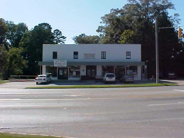
Property Detail
4801 20Th Ave
18-03-07-3-001-002.000
BEG 1993'(S) E OF NW COR OF SW1/4, RUN E125'(S), NW'LY40', E84.3' TO 20TH AVENUE, SE'LY ALONG AVENUE 70.35' TO 23RD BOULEVARD
Storesoffices
CHAMBERS
B and X Area of moderate flood hazard, usually the area between the limits of the 100-year and 500-year floods.
Alabama
2025
0.46 AC
2025
Chambers County
954600
Columbus GA
5,346 SF
LaGrange, GA-AL
NEARBY LISTINGS FOR SALE OR LEASE
-
-
View all Valley listings for sale on LoopNet.com
DEMOGRAPHICS near 4801 20Th Ave
1 mile
3 mile
5 mile
2025 Total Population
2,008
13,171
25,267
2030 Population
1,979
12,994
25,103
Pop Growth 2025-2030
(1.44%)
(1.34%)
(0.65%)
Average Age
41
41
41
2025 Total Households
803
5,437
10,181
HH Growth 2025-2030
(1.37%)
(1.36%)
(0.64%)
Median Household Inc
$48,481
$50,897
$51,845
Avg Household Size
2.30
2.30
2.40
2025 Avg HH Vehicles
2.00
2.00
2.00
Median Home Value
$136,200
$126,910
$135,989
Median Year Built
1968
1972
1974
Nearby Places
Map Layers
Map Styles
 Street
 Aerial
Layers
 Traffic
 Biking
Places
Listings with unknown addresses are not visible on the map
- Restaurants
- Banks
- Shops
- Fitness
- Groceries
PUBLIC TRANSPORTATION
AIRPORT
Columbus
Drive
Walk
Distance
Columbus
49 min
37.3 mi
SALE & LEASE HISTORY
LISTING DATE
SALE/LEASE

Sep 23, 2016
For Sale
Nearby Properties
Address
Land Use
TOTAL SIZE
Lot Size
Zoning
Address
Land Use
TOTAL SIZE
Lot Size
Zoning
7,668 SF
38.40 AC
Address
Land Use
TOTAL SIZE
Lot Size
Zoning
13,920 SF
58.66 AC
Address
Land Use
TOTAL SIZE
Lot Size
Zoning
375,360 SF
20.30 AC
Address
Land Use
TOTAL SIZE
Lot Size
Zoning
8,096 SF
9.40 AC
Address
Land Use
TOTAL SIZE
Lot Size
Zoning
113,361 SF
8.31 AC
Address
Land Use
TOTAL SIZE
Lot Size
Zoning
16,596 SF
2.77 AC
Address
Land Use
TOTAL SIZE
Lot Size
Zoning
6,990 SF
16 AC
Address
Land Use
TOTAL SIZE
Lot Size
Zoning
60,534 SF
5.94 AC
Address
Land Use
TOTAL SIZE
Lot Size
Zoning
64.60 AC
Address
Land Use
TOTAL SIZE
Lot Size
Zoning
884.65 AC
004
Address
Land Use
TOTAL SIZE
Lot Size
Zoning
715.28 AC
004
Address
Land Use
TOTAL SIZE
Lot Size
Zoning
146,616 SF
9.10 AC
Address
Land Use
TOTAL SIZE
Lot Size
Zoning
3,360 SF
3.50 AC
Address
Land Use
TOTAL SIZE
Lot Size
Zoning
3,936 SF
8.42 AC
Address
Land Use
TOTAL SIZE
Lot Size
Zoning
15,762 SF
7.23 AC
Address
Land Use
TOTAL SIZE
Lot Size
Zoning
42,144 SF
3.11 AC
Address
Land Use
TOTAL SIZE
Lot Size
Zoning
28,000 SF
4.05 AC
Address
Land Use
TOTAL SIZE
Lot Size
Zoning
4,132 SF
7.88 AC
Address
Land Use
TOTAL SIZE
Lot Size
Zoning
2,856 SF
6.50 AC
Address
Land Use
TOTAL SIZE
Lot Size
Zoning
31,581 SF
2.76 AC
Address
Land Use
TOTAL SIZE
Lot Size
Zoning
20,500 SF
4.40 AC
Address
Land Use
TOTAL SIZE
Lot Size
Zoning
25,924 SF
3.20 AC
Address
Land Use
TOTAL SIZE
Lot Size
Zoning
10,999 SF
1.88 AC
Address
Land Use
TOTAL SIZE
Lot Size
Zoning
9,057 SF
3.90 AC
Address
Land Use
TOTAL SIZE
Lot Size
Zoning
7,072 SF
2.69 AC
Address
Land Use
TOTAL SIZE
Lot Size
Zoning
4,342 SF
2.70 AC
Address
Land Use
TOTAL SIZE
Lot Size
Zoning
10,465 SF
0.14 AC
Address
Land Use
TOTAL SIZE
Lot Size
Zoning
6,837 SF
12.70 AC
Address
Land Use
TOTAL SIZE
Lot Size
Zoning
2,832 SF
1.90 AC
Address
Land Use
TOTAL SIZE
Lot Size
Zoning
3,687 SF
0.41 AC
The World's #1 Commercial Real Estate Marketplace
Connect with us
© 2026 CoStar Group
The information above has been obtained from sources believed reliable. While we do not doubt its accuracy we have not verified it and make no guarantee, warranty or representation about it. It is your responsibility to independently confirm its accuracy and completeness. Any projections, opinions, assumptions, or estimates used are for example only and do not represent the current or future performance of the property. The value of this transaction to you depends on tax and other factors which should be evaluated by your tax, financial, and legal advisors. You and your advisors should conduct a careful, independent investigation of the property to determine to your satisfaction the suitability of the property for your needs.