Property Record
4801 Menaul Blvd Ne, Albuquerque, NM 87110
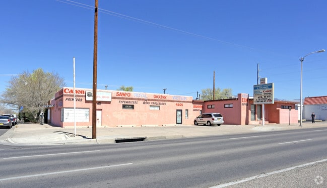

This Property Is For Sale
NEARBY LISTINGS FOR SALE OR LEASE
Property Detail
4801 Menaul Blvd Ne
Albuquerque, NM
Air Subd
1-017-059-410276-1-05-01
* 012 013BEL AIR SUBD W25FT L11
Storebuilding
Bernalillo
X
New Mexico
35001C0352H
12
2024
0.20 AC
2025
Northeast Heights
000207
Albuquerque
3,468 SF
DEMOGRAPHICS near 4801 Menaul Blvd Ne
1 Mile
3 Mile
5 Mile
2024 Total Population
13,970
121,138
303,627
2029 Population
13,969
121,777
304,299
Pop Growth 2024-2029
(0.01%)
+ 0.53%
+ 0.22%
Average Age
42
41
41
2024 Total Households
6,474
56,663
138,712
HH Growth 2024-2029
+ 0.03%
+ 0.56%
+ 0.21%
Median Household Inc
$54,014
$48,572
$52,125
Avg Household Size
2.10
2.00
2.10
2024 Avg HH Vehicles
2.00
2.00
2.00
Median Home Value
$209,895
$257,580
$256,663
Median Year Built
1961
1967
1972
Nearby Places
- Restaurants
- Banks
- Shops
- Fitness
- Groceries
PUBLIC TRANSPORTATION
COMMUTER RAIL
Montaño Station (NMRX - Rio Metro Regional Transit District)
DRIVE
WALK
Distance
Montaño Station (NMRX - Rio Metro Regional Transit District)
10 min
4.2 mi
Downtown Albuquerque (NMRX - Rio Metro Regional Transit District, Rail Runner Express - Rio Metro Regional Transit District)
DRIVE
WALK
Distance
Downtown Albuquerque (NMRX - Rio Metro Regional Transit District, Rail Runner Express - Rio Metro Regional Transit District)
10 min
5.4 mi
AIRPORT
Albuquerque International Sunport
DRIVE
WALK
Distance
Albuquerque International Sunport
21 min
8.2 mi
Freight Ports
Tulsa Port Of Catoosa
DRIVE
WALK
Distance
Tulsa Port Of Catoosa
685 min
659.5 mi
Nearby Properties
Address
Land Use
TOTAL SIZE
Lot Size
Zoning
Address
Land Use
TOTAL SIZE
Lot Size
Zoning
18,420 SF
18.94 AC
Address
Land Use
TOTAL SIZE
Lot Size
Zoning
2,880 SF
162.53 AC
Address
Land Use
TOTAL SIZE
Lot Size
Zoning
Address
Land Use
TOTAL SIZE
Lot Size
Zoning
254,392 SF
40.71 AC
Address
Land Use
TOTAL SIZE
Lot Size
Zoning
362,701 SF
32.55 AC
Address
Land Use
TOTAL SIZE
Lot Size
Zoning
231,258 SF
18.90 AC
Address
Land Use
TOTAL SIZE
Lot Size
Zoning
424,854 SF
20.23 AC
Address
Land Use
TOTAL SIZE
Lot Size
Zoning
Address
Land Use
TOTAL SIZE
Lot Size
Zoning
396,909 SF
3.39 AC
Address
Land Use
TOTAL SIZE
Lot Size
Zoning
Address
Land Use
TOTAL SIZE
Lot Size
Zoning
61,072 SF
130.31 AC
Address
Land Use
TOTAL SIZE
Lot Size
Zoning
15,610 SF
17.67 AC
Address
Land Use
TOTAL SIZE
Lot Size
Zoning
326,965 SF
51.32 AC
Address
Land Use
TOTAL SIZE
Lot Size
Zoning
200,652 SF
1.95 AC
Address
Land Use
TOTAL SIZE
Lot Size
Zoning
94,696 SF
4.34 AC
Address
Land Use
TOTAL SIZE
Lot Size
Zoning
59,072 SF
17.86 AC
Address
Land Use
TOTAL SIZE
Lot Size
Zoning
32.17 AC
Address
Land Use
TOTAL SIZE
Lot Size
Zoning
269,596 SF
9.33 AC
Address
Land Use
TOTAL SIZE
Lot Size
Zoning
378,973 SF
19.84 AC
Address
Land Use
TOTAL SIZE
Lot Size
Zoning
19,468 SF
60.34 AC
Address
Land Use
TOTAL SIZE
Lot Size
Zoning
176,357 SF
10.02 AC
Address
Land Use
TOTAL SIZE
Lot Size
Zoning
171,279 SF
8.88 AC
Address
Land Use
TOTAL SIZE
Lot Size
Zoning
202,182 SF
5 AC
Address
Land Use
TOTAL SIZE
Lot Size
Zoning
182,490 SF
1.85 AC
Address
Land Use
TOTAL SIZE
Lot Size
Zoning
219,132 SF
3.27 AC
Address
Land Use
TOTAL SIZE
Lot Size
Zoning
26,033 SF
7.28 AC
Address
Land Use
TOTAL SIZE
Lot Size
Zoning
198,694 SF
1.68 AC
Address
Land Use
TOTAL SIZE
Lot Size
Zoning
100,000 SF
202.08 AC
Address
Land Use
TOTAL SIZE
Lot Size
Zoning
37,771 SF
7.71 AC
Address
Land Use
TOTAL SIZE
Lot Size
Zoning
341,273 SF
19.25 AC
The World's #1 Commercial Real Estate Marketplace
Connect with us
© 2025 CoStar Group
The information above has been obtained from sources believed reliable. While we do not doubt its accuracy we have not verified it and make no guarantee, warranty or representation about it. It is your responsibility to independently confirm its accuracy and completeness. Any projections, opinions, assumptions, or estimates used are for example only and do not represent the current or future performance of the property. The value of this transaction to you depends on tax and other factors which should be evaluated by your tax, financial, and legal advisors. You and your advisors should conduct a careful, independent investigation of the property to determine to your satisfaction the suitability of the property for your needs.